Property Record
2012 Highway 29 N, Anderson, SC 29621
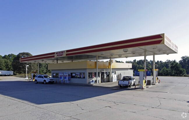


Property Detail
2012 Highway 29 N
175-02-03-002
CP S 1075/6B F178 D245 HWY 29N 1.00 AC
Commercialnec
Anderson
B and X Area of moderate flood hazard, usually the area between the limits of the 100-year and 500-year floods.
South Carolina
2025
1 AC
2025
Anderson Cy S of I-85
011302
Greenville/Spartanburg
3,080 SF
Greenville-Anderson-Greer, SC
NEARBY LISTINGS FOR SALE OR LEASE
DEMOGRAPHICS near 2012 Highway 29 N
1 mile
3 mile
5 mile
2025 Total Population
1,413
25,588
63,318
2030 Population
1,484
26,968
66,930
Pop Growth 2025-2030
+ 5.02%
+ 5.39%
+ 5.70%
Average Age
42
39
40
2025 Total Households
525
9,592
24,777
HH Growth 2025-2030
+ 5.14%
+ 5.41%
+ 5.85%
Median Household Inc
$59,687
$63,069
$57,404
Avg Household Size
2.50
2.40
2.40
2025 Avg HH Vehicles
2.00
2.00
2.00
Median Home Value
$198,539
$248,318
$235,661
Median Year Built
1984
1985
1981
Nearby Places
Map Layers
Map Styles
 Street
 Aerial
Transit
 Traffic
 Biking
Places
Listings with unknown addresses are not visible on the map
- Restaurants
- Banks
- Shops
- Fitness
- Groceries
PUBLIC TRANSPORTATION
AIRPORT
Greenville Spartanburg International
Drive
Walk
Distance
Greenville Spartanburg International
52 min
37.7 mi
Nearby Properties
Address
Land Use
TOTAL SIZE
Lot Size
Zoning
Address
Land Use
TOTAL SIZE
Lot Size
Zoning
17,286 SF
19.71 AC
Address
Land Use
TOTAL SIZE
Lot Size
Zoning
13,220 SF
13.49 AC
Address
Land Use
TOTAL SIZE
Lot Size
Zoning
15,168 SF
11.99 AC
Address
Land Use
TOTAL SIZE
Lot Size
Zoning
7,568 SF
10.99 AC
Address
Land Use
TOTAL SIZE
Lot Size
Zoning
25,908 SF
12.50 AC
Address
Land Use
TOTAL SIZE
Lot Size
Zoning
42,416 SF
6.45 AC
Address
Land Use
TOTAL SIZE
Lot Size
Zoning
91,698 SF
10.04 AC
Address
Land Use
TOTAL SIZE
Lot Size
Zoning
40,071 SF
18.83 AC
Address
Land Use
TOTAL SIZE
Lot Size
Zoning
80,205 SF
9.58 AC
Address
Land Use
TOTAL SIZE
Lot Size
Zoning
46,410 SF
4.88 AC
Address
Land Use
TOTAL SIZE
Lot Size
Zoning
24.90 AC
Address
Land Use
TOTAL SIZE
Lot Size
Zoning
9,406 SF
7.92 AC
Address
Land Use
TOTAL SIZE
Lot Size
Zoning
1,408 SF
20.24 AC
Address
Land Use
TOTAL SIZE
Lot Size
Zoning
31,970 SF
2.87 AC
Address
Land Use
TOTAL SIZE
Lot Size
Zoning
2,315 SF
Address
Land Use
TOTAL SIZE
Lot Size
Zoning
4,068 SF
3.58 AC
Address
Land Use
TOTAL SIZE
Lot Size
Zoning
6,590 SF
1.83 AC
Address
Land Use
TOTAL SIZE
Lot Size
Zoning
86.27 AC
Address
Land Use
TOTAL SIZE
Lot Size
Zoning
14,749 SF
1.58 AC
Address
Land Use
TOTAL SIZE
Lot Size
Zoning
12,500 SF
1.70 AC
Address
Land Use
TOTAL SIZE
Lot Size
Zoning
Address
Land Use
TOTAL SIZE
Lot Size
Zoning
30,796 SF
3.56 AC
Address
Land Use
TOTAL SIZE
Lot Size
Zoning
24,661 SF
41.82 AC
Address
Land Use
TOTAL SIZE
Lot Size
Zoning
19,728 SF
2.23 AC
Address
Land Use
TOTAL SIZE
Lot Size
Zoning
12,661 SF
1.61 AC
Address
Land Use
TOTAL SIZE
Lot Size
Zoning
6,220 SF
1.58 AC
Address
Land Use
TOTAL SIZE
Lot Size
Zoning
24,195 SF
0.59 AC
Address
Land Use
TOTAL SIZE
Lot Size
Zoning
60.83 AC
The World's #1 Commercial Real Estate Marketplace
Connect with us
© 2026 CoStar Group
The information above has been obtained from sources believed reliable. While we do not doubt its accuracy we have not verified it and make no guarantee, warranty or representation about it. It is your responsibility to independently confirm its accuracy and completeness. Any projections, opinions, assumptions, or estimates used are for example only and do not represent the current or future performance of the property. The value of this transaction to you depends on tax and other factors which should be evaluated by your tax, financial, and legal advisors. You and your advisors should conduct a careful, independent investigation of the property to determine to your satisfaction the suitability of the property for your needs.