Property Record
2012 Miller Cutrd Rd, La Porte, TX 77571
Current Lease Availabilities
Property Detail
2012 Miller Cutrd Rd
Houston-Pasadena-The Woodlands, TX
TR 2 ABST 46 A MCCORMICK
0410020040005
HARRIS
Industrialgeneral
Texas
AE The base floodplain where base flood elevations are provided. AE Zones are now used on new format FIRMs instead of A1-A30 Zones.
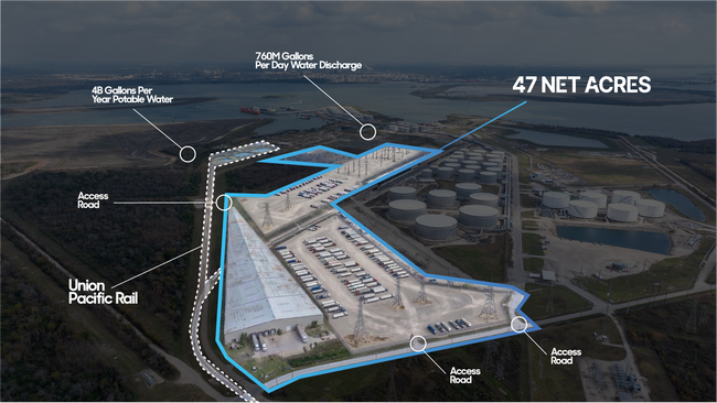
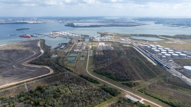
96.87 AC
2025
Gulf Freeway/Pasadena
2025
Houston
343601
NEARBY LISTINGS FOR SALE OR LEASE
DEMOGRAPHICS near 2012 Miller Cutrd Rd
1 mile
3 mile
5 mile
2025 Total Population
0
3,961
78,304
2030 Population
0
4,262
83,462
Pop Growth 2025-2030
0.00%
+ 7.60%
+ 6.59%
Average Age
0
40
38
2025 Total Households
0
1,359
27,217
HH Growth 2025-2030
0.00%
+ 7.80%
+ 6.72%
Median Household Inc
$0
$73,781
$79,864
Avg Household Size
.00
2.90
2.80
2025 Avg HH Vehicles
.00
2.00
2.00
Median Home Value
$0
$203,795
$252,945
Median Year Built
0
1973
1982
Nearby Places
Map Layers
Map Styles
 Street
 Aerial
Layers
 Traffic
 Biking
Places
Listings with unknown addresses are not visible on the map
- Restaurants
- Banks
- Shops
- Fitness
- Groceries
PUBLIC TRANSPORTATION
AIRPORT
William P Hobby
Drive
Walk
Distance
William P Hobby
42 min
21.3 mi
George Bush Intcntl/Houston
Drive
Walk
Distance
George Bush Intcntl/Houston
51 min
34.1 mi
Freight Ports
Port of Houston
Drive
Walk
Distance
Port of Houston
33 min
17.0 mi
Nearby Properties
Address
Land Use
TOTAL SIZE
Lot Size
Zoning
Address
Land Use
TOTAL SIZE
Lot Size
Zoning
55.98 AC
Address
Land Use
TOTAL SIZE
Lot Size
Zoning
Address
Land Use
TOTAL SIZE
Lot Size
Zoning
Address
Land Use
TOTAL SIZE
Lot Size
Zoning
12,525,600 SF
260.20 AC
Address
Land Use
TOTAL SIZE
Lot Size
Zoning
263.71 AC
Address
Land Use
TOTAL SIZE
Lot Size
Zoning
4,960,504 SF
141.62 AC
Address
Land Use
TOTAL SIZE
Lot Size
Zoning
8,735,136 SF
185.66 AC
Address
Land Use
TOTAL SIZE
Lot Size
Zoning
36.31 AC
Address
Land Use
TOTAL SIZE
Lot Size
Zoning
38.27 AC
Address
Land Use
TOTAL SIZE
Lot Size
Zoning
Address
Land Use
TOTAL SIZE
Lot Size
Zoning
Address
Land Use
TOTAL SIZE
Lot Size
Zoning
2,211,400 SF
101.25 AC
Address
Land Use
TOTAL SIZE
Lot Size
Zoning
900,000 SF
42.88 AC
Address
Land Use
TOTAL SIZE
Lot Size
Zoning
120.26 AC
Address
Land Use
TOTAL SIZE
Lot Size
Zoning
Address
Land Use
TOTAL SIZE
Lot Size
Zoning
46.10 AC
Address
Land Use
TOTAL SIZE
Lot Size
Zoning
66.05 AC
Address
Land Use
TOTAL SIZE
Lot Size
Zoning
1,120,800 SF
35.24 AC
Address
Land Use
TOTAL SIZE
Lot Size
Zoning
711,094 SF
35.47 AC
Address
Land Use
TOTAL SIZE
Lot Size
Zoning
197.11 AC
Address
Land Use
TOTAL SIZE
Lot Size
Zoning
56.69 AC
Address
Land Use
TOTAL SIZE
Lot Size
Zoning
66.50 AC
Address
Land Use
TOTAL SIZE
Lot Size
Zoning
Address
Land Use
TOTAL SIZE
Lot Size
Zoning
Address
Land Use
TOTAL SIZE
Lot Size
Zoning
Address
Land Use
TOTAL SIZE
Lot Size
Zoning
38.51 AC
Address
Land Use
TOTAL SIZE
Lot Size
Zoning
414,900 SF
25.29 AC
Address
Land Use
TOTAL SIZE
Lot Size
Zoning
184.18 AC
Address
Land Use
TOTAL SIZE
Lot Size
Zoning
109.58 AC
Address
Land Use
TOTAL SIZE
Lot Size
Zoning
21.83 AC
The World's #1 Commercial Real Estate Marketplace
Connect with us
© 2026 CoStar Group
The information above has been obtained from sources believed reliable. While we do not doubt its accuracy we have not verified it and make no guarantee, warranty or representation about it. It is your responsibility to independently confirm its accuracy and completeness. Any projections, opinions, assumptions, or estimates used are for example only and do not represent the current or future performance of the property. The value of this transaction to you depends on tax and other factors which should be evaluated by your tax, financial, and legal advisors. You and your advisors should conduct a careful, independent investigation of the property to determine to your satisfaction the suitability of the property for your needs.