Property Record
2012 N W St, Pensacola, FL 32505
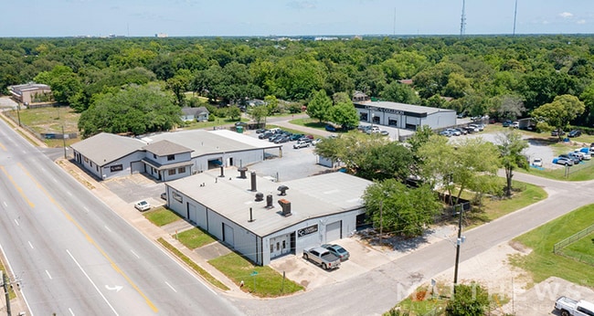

This Property Is For Sale
Current Lease Availabilities
NEARBY LISTINGS FOR SALE OR LEASE
Property Detail
2012 N W St
Pensacola-Ferry Pass-Brent, FL
Hazlehurst Plat
17-2S-30-1300-016-040
LT 16 AND LT 17 BLK 40 HAZELHURST PLAT DB 55 P 262 OR 8342 P 1985 & S 1/2 ADJOINING ALLEY OR 2417 P 429 LESS CASE #70-1443 COUNTY RD R/W FOR W STREET SEC 17/31 T 2S R 30
Vehiclerentalsvehiclesales
Escambia
X
Florida
12033C0390G
16
2023
0.21 AC
2024
West Pensacola
002000
Pensacola
5,000 SF
DEMOGRAPHICS near 2012 N W St
1 Mile
3 Mile
5 Mile
2024 Total Population
9,289
72,654
143,679
2029 Population
9,749
74,859
146,930
Pop Growth 2024-2029
+ 4.95%
+ 3.03%
+ 2.26%
Average Age
39
38
39
2024 Total Households
3,400
28,929
57,559
HH Growth 2024-2029
+ 4.88%
+ 3.09%
+ 2.32%
Median Household Inc
$27,442
$37,196
$45,281
Avg Household Size
2.30
2.30
2.30
2024 Avg HH Vehicles
1.00
1.00
2.00
Median Home Value
$78,872
$134,790
$168,953
Median Year Built
1971
1967
1973
Nearby Places
- Restaurants
- Banks
- Shops
- Fitness
- Groceries
PUBLIC TRANSPORTATION
AIRPORT
Pensacola International
DRIVE
WALK
Distance
Pensacola International
12 min
5.4 mi
Freight Ports
Port of Mobile
DRIVE
WALK
Distance
Port of Mobile
66 min
56.0 mi
Nearby Properties
Address
Land Use
TOTAL SIZE
Lot Size
Zoning
Address
Land Use
TOTAL SIZE
Lot Size
Zoning
820,379 SF
52.64 AC
C-3
Address
Land Use
TOTAL SIZE
Lot Size
Zoning
544,835 SF
3.29 AC
C-2,C-2A
Address
Land Use
TOTAL SIZE
Lot Size
Zoning
1,479,067 SF
77.37 AC
COM
Address
Land Use
TOTAL SIZE
Lot Size
Zoning
365,037 SF
5.79 AC
C-3
Address
Land Use
TOTAL SIZE
Lot Size
Zoning
368,724 SF
3.17 AC
C-2A
Address
Land Use
TOTAL SIZE
Lot Size
Zoning
56,970 SF
5.94 AC
WRD
Address
Land Use
TOTAL SIZE
Lot Size
Zoning
289,397 SF
12.38 AC
PUB
Address
Land Use
TOTAL SIZE
Lot Size
Zoning
250,232 SF
19.24 AC
HDR
Address
Land Use
TOTAL SIZE
Lot Size
Zoning
485,500 SF
15.92 AC
COM
Address
Land Use
TOTAL SIZE
Lot Size
Zoning
327,045 SF
7.47 AC
C-2A
Address
Land Use
TOTAL SIZE
Lot Size
Zoning
178,451 SF
3.88 AC
GRD
Address
Land Use
TOTAL SIZE
Lot Size
Zoning
114,000 SF
3.23 AC
C-2,C-2A
Address
Land Use
TOTAL SIZE
Lot Size
Zoning
96,686 SF
1.06 AC
C-2A
Address
Land Use
TOTAL SIZE
Lot Size
Zoning
282,738 SF
14.64 AC
PUB
Address
Land Use
TOTAL SIZE
Lot Size
Zoning
258,438 SF
48.49 AC
PUB
Address
Land Use
TOTAL SIZE
Lot Size
Zoning
99,623 SF
1.87 AC
C-2A
Address
Land Use
TOTAL SIZE
Lot Size
Zoning
145,264 SF
9.84 AC
SSD
Address
Land Use
TOTAL SIZE
Lot Size
Zoning
169,346 SF
15.21 AC
HDR
Address
Land Use
TOTAL SIZE
Lot Size
Zoning
115,500 SF
3.48 AC
C-2
Address
Land Use
TOTAL SIZE
Lot Size
Zoning
169,963 SF
15.43 AC
HC/LI
Address
Land Use
TOTAL SIZE
Lot Size
Zoning
151,996 SF
30.44 AC
HDR
Address
Land Use
TOTAL SIZE
Lot Size
Zoning
166,204 SF
0.97 AC
C-2A
Address
Land Use
TOTAL SIZE
Lot Size
Zoning
75,877 SF
1.55 AC
WRD
Address
Land Use
TOTAL SIZE
Lot Size
Zoning
76,703 SF
7.01 AC
C-1,R-1AA
Address
Land Use
TOTAL SIZE
Lot Size
Zoning
171,446 SF
14.83 AC
R-2A
Address
Land Use
TOTAL SIZE
Lot Size
Zoning
130,516 SF
4.55 AC
R-2
Address
Land Use
TOTAL SIZE
Lot Size
Zoning
55,337 SF
0.95 AC
C-2A,HC-2
Address
Land Use
TOTAL SIZE
Lot Size
Zoning
99,147 SF
5.89 AC
HDMU
Address
Land Use
TOTAL SIZE
Lot Size
Zoning
116,020 SF
4.71 AC
MDR
Address
Land Use
TOTAL SIZE
Lot Size
Zoning
81,549 SF
0.46 AC
WRD
The World's #1 Commercial Real Estate Marketplace
Connect with us
© 2025 CoStar Group
The information above has been obtained from sources believed reliable. While we do not doubt its accuracy we have not verified it and make no guarantee, warranty or representation about it. It is your responsibility to independently confirm its accuracy and completeness. Any projections, opinions, assumptions, or estimates used are for example only and do not represent the current or future performance of the property. The value of this transaction to you depends on tax and other factors which should be evaluated by your tax, financial, and legal advisors. You and your advisors should conduct a careful, independent investigation of the property to determine to your satisfaction the suitability of the property for your needs.