Property Record
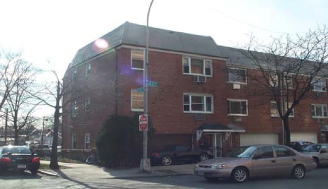
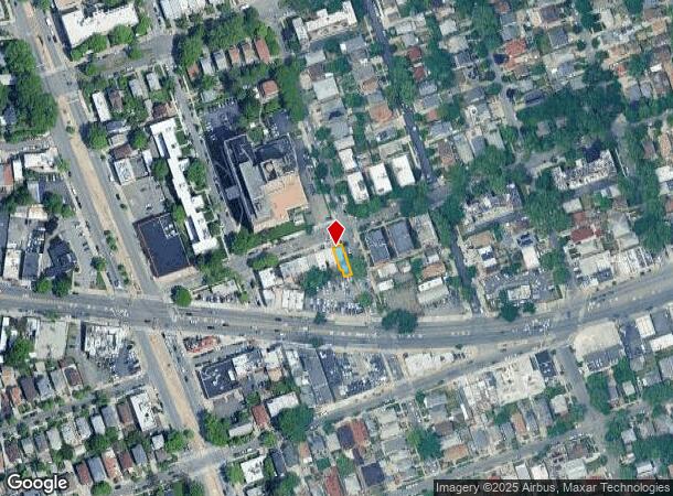
20124 43Rd Ave, Bayside, NY 11361
NEARBY LISTINGS FOR SALE OR LEASE
Property Detail
20124 43Rd Ave
06262-0012
Queens
Commercialofficeresidentialmixeduse
New York
X
12
3604970118F
0.04 AC
2024
Auburndale
2025
Long Island (New York)
146300
New York-Jersey City-White Plains, NY-NJ
4,100 SF
DEMOGRAPHICS near 20124 43Rd Ave
1 mile
3 mile
5 mile
2024 Total Population
53,873
447,686
1,208,207
2029 Population
50,030
421,216
1,134,074
Pop Growth 2024-2029
(7.13%)
(5.91%)
(6.14%)
Average Age
44
44
42
2024 Total Households
18,952
159,787
414,546
HH Growth 2024-2029
(7.62%)
(6.28%)
(6.26%)
Median Household Inc
$85,616
$69,899
$75,309
Avg Household Size
2.80
2.70
2.80
2024 Avg HH Vehicles
1.00
1.00
1.00
Median Home Value
$811,554
$726,398
$692,902
Median Year Built
1951
1956
1954
Nearby Places
Map Layers
Map Styles
 Street
 Aerial
Transit
 Traffic
 Biking
Places
Listings with unknown addresses are not visible on the map
- Restaurants
- Banks
- Shops
- Fitness
- Groceries
PUBLIC TRANSPORTATION
TRANSIT/SUBWAY
Auburndale Station (Port Washington Branch - Long Island Rail Road)
Drive
Walk
Distance
Auburndale Station (Port Washington Branch - Long Island Rail Road)
2 min
12 min
0.6 mi
COMMUTER RAIL
Auburndale Station (Port Washington Branch - Long Island Rail Road)
Drive
Walk
Distance
Auburndale Station (Port Washington Branch - Long Island Rail Road)
2 min
12 min
0.6 mi
Bayside Station (Port Washington Branch - Long Island Rail Road)
Drive
Walk
Distance
Bayside Station (Port Washington Branch - Long Island Rail Road)
3 min
17 min
0.9 mi
AIRPORT
LaGuardia
Drive
Walk
Distance
LaGuardia
14 min
6.0 mi
John F Kennedy International
Drive
Walk
Distance
John F Kennedy International
18 min
11.7 mi
Newark Liberty International
Drive
Walk
Distance
Newark Liberty International
40 min
32.6 mi
Freight Ports
NY - Red Hook Container Terminal
Drive
Walk
Distance
NY - Red Hook Container Terminal
26 min
16.3 mi
Nearby Properties
Address
Land Use
TOTAL SIZE
Lot Size
Zoning
Address
Land Use
TOTAL SIZE
Lot Size
Zoning
2,697,663 SF
3.46 AC
C5-3
Address
Land Use
TOTAL SIZE
Lot Size
Zoning
1,666,696 SF
1.87 AC
C52.5
Address
Land Use
TOTAL SIZE
Lot Size
Zoning
7,975 SF
133 AC
PARK
Address
Land Use
TOTAL SIZE
Lot Size
Zoning
4,528,000 SF
94.27 AC
R4
Address
Land Use
TOTAL SIZE
Lot Size
Zoning
2,078,606 SF
58.93 AC
R4
Address
Land Use
TOTAL SIZE
Lot Size
Zoning
986,724 SF
89.79 AC
R3-2
Address
Land Use
TOTAL SIZE
Lot Size
Zoning
878,386 SF
20.55 AC
R4
Address
Land Use
TOTAL SIZE
Lot Size
Zoning
800 SF
104.61 AC
PARK
Address
Land Use
TOTAL SIZE
Lot Size
Zoning
13,500 SF
104 AC
PARK
Address
Land Use
TOTAL SIZE
Lot Size
Zoning
421,996 SF
136.05 AC
R3-1
Address
Land Use
TOTAL SIZE
Lot Size
Zoning
554,300 SF
20.72 AC
R3-2
Address
Land Use
TOTAL SIZE
Lot Size
Zoning
554,300 SF
20.72 AC
R3-2
Address
Land Use
TOTAL SIZE
Lot Size
Zoning
4,050 SF
113.40 AC
PARK
Address
Land Use
TOTAL SIZE
Lot Size
Zoning
947 SF
101.82 AC
PARK
Address
Land Use
TOTAL SIZE
Lot Size
Zoning
4,800 SF
80.10 AC
PARK
Address
Land Use
TOTAL SIZE
Lot Size
Zoning
749,142 SF
16.48 AC
R6
Address
Land Use
TOTAL SIZE
Lot Size
Zoning
749,142 SF
16.48 AC
R6
Address
Land Use
TOTAL SIZE
Lot Size
Zoning
749,142 SF
16.48 AC
R6
Address
Land Use
TOTAL SIZE
Lot Size
Zoning
749,142 SF
16.48 AC
R6
Address
Land Use
TOTAL SIZE
Lot Size
Zoning
749,142 SF
16.48 AC
R6
Address
Land Use
TOTAL SIZE
Lot Size
Zoning
749,142 SF
16.48 AC
R6
Address
Land Use
TOTAL SIZE
Lot Size
Zoning
749,142 SF
16.48 AC
R6
Address
Land Use
TOTAL SIZE
Lot Size
Zoning
1,186,778 SF
31.45 AC
R4
Address
Land Use
TOTAL SIZE
Lot Size
Zoning
448,500 SF
22.59 AC
R3-2
Address
Land Use
TOTAL SIZE
Lot Size
Zoning
644,836 SF
14.26 AC
R5
Address
Land Use
TOTAL SIZE
Lot Size
Zoning
644,836 SF
14.26 AC
R5
Address
Land Use
TOTAL SIZE
Lot Size
Zoning
644,836 SF
14.26 AC
R5
Address
Land Use
TOTAL SIZE
Lot Size
Zoning
644,836 SF
14.26 AC
R5
Address
Land Use
TOTAL SIZE
Lot Size
Zoning
644,836 SF
14.26 AC
R5
Address
Land Use
TOTAL SIZE
Lot Size
Zoning
644,836 SF
14.26 AC
R5
The World's #1 Commercial Real Estate Marketplace
Connect with us
© 2026 CoStar Group
The information above has been obtained from sources believed reliable. While we do not doubt its accuracy we have not verified it and make no guarantee, warranty or representation about it. It is your responsibility to independently confirm its accuracy and completeness. Any projections, opinions, assumptions, or estimates used are for example only and do not represent the current or future performance of the property. The value of this transaction to you depends on tax and other factors which should be evaluated by your tax, financial, and legal advisors. You and your advisors should conduct a careful, independent investigation of the property to determine to your satisfaction the suitability of the property for your needs.