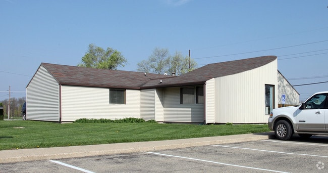
Property Record
2013 E Main St, Danville, IN 46122


NEARBY LISTINGS FOR SALE OR LEASE
Property Detail
2013 E Main St
32-11-01-365-006.000-002
PT W SW 1-15-1W 1.6 AC
Commercialnec
Hendricks
X
Indiana
18063C0165D
1.60 AC
2024
Hendricks County
2024
Indianapolis
210502
Indianapolis-Carmel-Greenwood, IN
2,576 SF
DEMOGRAPHICS near 2013 E Main St
1 mile
3 mile
5 mile
2024 Total Population
2,629
17,015
38,942
2029 Population
2,937
19,060
43,554
Pop Growth 2024-2029
+ 11.72%
+ 12.02%
+ 11.84%
Average Age
41
41
41
2024 Total Households
1,020
6,516
14,566
HH Growth 2024-2029
+ 11.76%
+ 12.03%
+ 11.89%
Median Household Inc
$94,432
$97,330
$100,871
Avg Household Size
2.50
2.50
2.60
2024 Avg HH Vehicles
2.00
2.00
2.00
Median Home Value
$216,355
$256,491
$262,893
Median Year Built
1995
1992
1995
Nearby Places
Map Layers
Map Styles
 Street
 Aerial
Transit
 Traffic
 Biking
Places
Listings with unknown addresses are not visible on the map
- Restaurants
- Banks
- Shops
- Fitness
- Groceries
PUBLIC TRANSPORTATION
AIRPORT
Indianapolis International
Drive
Walk
Distance
Indianapolis International
30 min
15.7 mi
Nearby Properties
Address
Land Use
TOTAL SIZE
Lot Size
Zoning
Address
Land Use
TOTAL SIZE
Lot Size
Zoning
15,912 SF
29.86 AC
Address
Land Use
TOTAL SIZE
Lot Size
Zoning
100 SF
5.07 AC
Address
Land Use
TOTAL SIZE
Lot Size
Zoning
1,215 SF
26.36 AC
Address
Land Use
TOTAL SIZE
Lot Size
Zoning
10,528 SF
12.54 AC
Address
Land Use
TOTAL SIZE
Lot Size
Zoning
1,274 SF
10.48 AC
Address
Land Use
TOTAL SIZE
Lot Size
Zoning
156,080 SF
15.18 AC
Address
Land Use
TOTAL SIZE
Lot Size
Zoning
10,500 SF
10 AC
Address
Land Use
TOTAL SIZE
Lot Size
Zoning
55,285 SF
5 AC
Address
Land Use
TOTAL SIZE
Lot Size
Zoning
31,322 SF
10.48 AC
Address
Land Use
TOTAL SIZE
Lot Size
Zoning
1,946 SF
28 AC
Address
Land Use
TOTAL SIZE
Lot Size
Zoning
37,200 SF
8.98 AC
Address
Land Use
TOTAL SIZE
Lot Size
Zoning
64,062 SF
7.53 AC
Address
Land Use
TOTAL SIZE
Lot Size
Zoning
597 SF
24.56 AC
Address
Land Use
TOTAL SIZE
Lot Size
Zoning
2,244 SF
9.86 AC
Address
Land Use
TOTAL SIZE
Lot Size
Zoning
3,114 SF
3.04 AC
Address
Land Use
TOTAL SIZE
Lot Size
Zoning
51,636 SF
6.14 AC
Address
Land Use
TOTAL SIZE
Lot Size
Zoning
18,970 SF
3.26 AC
Address
Land Use
TOTAL SIZE
Lot Size
Zoning
19,932 SF
12.34 AC
Address
Land Use
TOTAL SIZE
Lot Size
Zoning
5,600 SF
12.29 AC
Address
Land Use
TOTAL SIZE
Lot Size
Zoning
29,586 SF
7.44 AC
Address
Land Use
TOTAL SIZE
Lot Size
Zoning
12,360 SF
6.86 AC
Address
Land Use
TOTAL SIZE
Lot Size
Zoning
6,023 SF
4.32 AC
Address
Land Use
TOTAL SIZE
Lot Size
Zoning
38,015 SF
10.41 AC
Address
Land Use
TOTAL SIZE
Lot Size
Zoning
24,820 SF
9.59 AC
Address
Land Use
TOTAL SIZE
Lot Size
Zoning
5,304 SF
7.92 AC
Address
Land Use
TOTAL SIZE
Lot Size
Zoning
17,904 SF
14.34 AC
Address
Land Use
TOTAL SIZE
Lot Size
Zoning
5,075 SF
2.13 AC
Address
Land Use
TOTAL SIZE
Lot Size
Zoning
5,066 SF
8.52 AC
Address
Land Use
TOTAL SIZE
Lot Size
Zoning
10,360 SF
7.68 AC
Address
Land Use
TOTAL SIZE
Lot Size
Zoning
12,480 SF
2.82 AC
The World's #1 Commercial Real Estate Marketplace
Connect with us
© 2026 CoStar Group
The information above has been obtained from sources believed reliable. While we do not doubt its accuracy we have not verified it and make no guarantee, warranty or representation about it. It is your responsibility to independently confirm its accuracy and completeness. Any projections, opinions, assumptions, or estimates used are for example only and do not represent the current or future performance of the property. The value of this transaction to you depends on tax and other factors which should be evaluated by your tax, financial, and legal advisors. You and your advisors should conduct a careful, independent investigation of the property to determine to your satisfaction the suitability of the property for your needs.