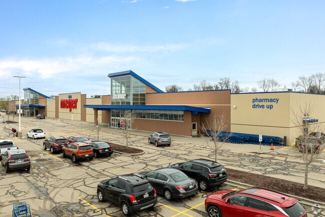
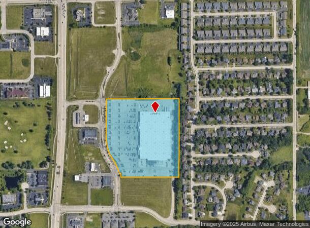
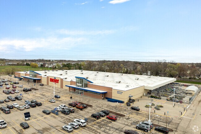
Property Record
2013 Mcfarland Rd, Rockford, IL 61107
NEARBY LISTINGS FOR SALE OR LEASE
Property Detail
2013 Mcfarland Rd
Rockford, IL
Perryville Promenade Phase 1 Sub
12-14-151-005
PERRYVILLE PROMENADE PHASE 1 SUB PT NW1/4 SEC 14-44-2 LT 3
Commercialnec
Winnebago
X
Illinois
17201C0286E
3
2024
10.63 AC
2024
I-39 Corr/Winnebago Cnty
000512
Chicago
195,672 SF
DEMOGRAPHICS near 2013 Mcfarland Rd
1 Mile
3 Mile
5 Mile
2024 Total Population
3,669
41,984
115,418
2029 Population
3,619
41,405
113,667
Pop Growth 2024-2029
(1.36%)
(1.38%)
(1.52%)
Average Age
44
44
42
2024 Total Households
1,547
17,772
47,956
HH Growth 2024-2029
(1.23%)
(1.36%)
(1.54%)
Median Household Inc
$70,210
$74,734
$64,562
Avg Household Size
2.30
2.30
2.30
2024 Avg HH Vehicles
2.00
2.00
2.00
Median Home Value
$197,891
$177,564
$153,914
Median Year Built
1992
1987
1974
Nearby Places
Map Layers
Map Styles
 Street
 Aerial
- Restaurants
- Banks
- Shops
- Fitness
- Groceries
PUBLIC TRANSPORTATION
AIRPORT
Chicago/Rockford International
DRIVE
WALK
Distance
Chicago/Rockford International
28 min
15.1 mi
Freight Ports
Port Milwaukee
DRIVE
WALK
Distance
Port Milwaukee
106 min
88.4 mi
Nearby Properties
Address
Land Use
TOTAL SIZE
Lot Size
Zoning
Address
Land Use
TOTAL SIZE
Lot Size
Zoning
177,667 SF
22.14 AC
C3
Address
Land Use
TOTAL SIZE
Lot Size
Zoning
Address
Land Use
TOTAL SIZE
Lot Size
Zoning
302,569 SF
24.58 AC
C2
Address
Land Use
TOTAL SIZE
Lot Size
Zoning
Address
Land Use
TOTAL SIZE
Lot Size
Zoning
Address
Land Use
TOTAL SIZE
Lot Size
Zoning
218,420 SF
33.07 AC
C3
Address
Land Use
TOTAL SIZE
Lot Size
Zoning
169,198 SF
14 AC
C3
Address
Land Use
TOTAL SIZE
Lot Size
Zoning
69,864 SF
9.39 AC
C3
Address
Land Use
TOTAL SIZE
Lot Size
Zoning
138,658 SF
12.91 AC
C2
Address
Land Use
TOTAL SIZE
Lot Size
Zoning
213,659 SF
18 AC
IL
Address
Land Use
TOTAL SIZE
Lot Size
Zoning
10.01 AC
Address
Land Use
TOTAL SIZE
Lot Size
Zoning
134,779 SF
9.93 AC
C2
Address
Land Use
TOTAL SIZE
Lot Size
Zoning
217,520 SF
13.82 AC
C3
Address
Land Use
TOTAL SIZE
Lot Size
Zoning
119,560 SF
2.89 AC
R1
Address
Land Use
TOTAL SIZE
Lot Size
Zoning
151,523 SF
16.05 AC
CR
Address
Land Use
TOTAL SIZE
Lot Size
Zoning
79,055 SF
10.89 AC
R4
Address
Land Use
TOTAL SIZE
Lot Size
Zoning
65,541 SF
24.36 AC
C3
Address
Land Use
TOTAL SIZE
Lot Size
Zoning
200,666 SF
28.90 AC
IL
Address
Land Use
TOTAL SIZE
Lot Size
Zoning
110,218 SF
8.12 AC
C2
Address
Land Use
TOTAL SIZE
Lot Size
Zoning
160,288 SF
5.70 AC
C3
Address
Land Use
TOTAL SIZE
Lot Size
Zoning
96,130 SF
12.47 AC
R2
Address
Land Use
TOTAL SIZE
Lot Size
Zoning
67,360 SF
5.91 AC
C2
Address
Land Use
TOTAL SIZE
Lot Size
Zoning
73,031 SF
10.23 AC
C1
Address
Land Use
TOTAL SIZE
Lot Size
Zoning
70,986 SF
4.33 AC
OF
Address
Land Use
TOTAL SIZE
Lot Size
Zoning
141,752 SF
12.10 AC
C2
Address
Land Use
TOTAL SIZE
Lot Size
Zoning
19,406 SF
10.13 AC
R4
Address
Land Use
TOTAL SIZE
Lot Size
Zoning
128,736 SF
14.64 AC
C2
Address
Land Use
TOTAL SIZE
Lot Size
Zoning
142,140 SF
13.44 AC
C2
Address
Land Use
TOTAL SIZE
Lot Size
Zoning
71,799 SF
4.51 AC
C1
The World's #1 Commercial Real Estate Marketplace
Connect with us
© 2025 CoStar Group
The information above has been obtained from sources believed reliable. While we do not doubt its accuracy we have not verified it and make no guarantee, warranty or representation about it. It is your responsibility to independently confirm its accuracy and completeness. Any projections, opinions, assumptions, or estimates used are for example only and do not represent the current or future performance of the property. The value of this transaction to you depends on tax and other factors which should be evaluated by your tax, financial, and legal advisors. You and your advisors should conduct a careful, independent investigation of the property to determine to your satisfaction the suitability of the property for your needs.