Property Record
2013 N Rapids Rd, Manitowoc, WI 54220
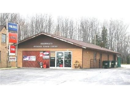

Property Detail
2013 N Rapids Rd
052-814-102-160.00
PT NW1/4 NE1/4 COM SE COR N351.2 W528 N155 TO POB N150 W265 TO EDGE OF RD SLY153.35E230 TO BEG SEC 14-19-23
Commercialnec
Manitowoc
B and X Area of moderate flood hazard, usually the area between the limits of the 100-year and 500-year floods.
Wisconsin
2025
0.85 AC
2025
Wisconsin South Area
000300
Other Market Areas
2,880 SF
Manitowoc, WI
NEARBY LISTINGS FOR SALE OR LEASE
DEMOGRAPHICS near 2013 N Rapids Rd
1 mile
3 mile
5 mile
2025 Total Population
3,208
21,612
38,994
2030 Population
3,182
21,528
38,912
Pop Growth 2025-2030
(0.81%)
(0.39%)
(0.21%)
Average Age
49
44
44
2025 Total Households
1,374
9,473
17,064
HH Growth 2025-2030
(0.87%)
(0.41%)
(0.22%)
Median Household Inc
$73,741
$63,927
$62,803
Avg Household Size
2.30
2.20
2.20
2025 Avg HH Vehicles
2.00
2.00
2.00
Median Home Value
$270,994
$181,861
$180,381
Median Year Built
1990
1964
1961
Nearby Places
Map Layers
Map Styles
 Street
 Aerial
Layers
 Traffic
 Biking
Places
Listings with unknown addresses are not visible on the map
- Restaurants
- Banks
- Shops
- Fitness
- Groceries
Nearby Properties
Address
Land Use
TOTAL SIZE
Lot Size
Zoning
Address
Land Use
TOTAL SIZE
Lot Size
Zoning
74,004 SF
12.64 AC
Address
Land Use
TOTAL SIZE
Lot Size
Zoning
66,328 SF
6.09 AC
Address
Land Use
TOTAL SIZE
Lot Size
Zoning
15.62 AC
Address
Land Use
TOTAL SIZE
Lot Size
Zoning
29.89 AC
Address
Land Use
TOTAL SIZE
Lot Size
Zoning
187,990 SF
12.45 AC
Address
Land Use
TOTAL SIZE
Lot Size
Zoning
7.08 AC
Address
Land Use
TOTAL SIZE
Lot Size
Zoning
59,680 SF
6.40 AC
Address
Land Use
TOTAL SIZE
Lot Size
Zoning
8.50 AC
Address
Land Use
TOTAL SIZE
Lot Size
Zoning
37.85 AC
Address
Land Use
TOTAL SIZE
Lot Size
Zoning
10.01 AC
B2
Address
Land Use
TOTAL SIZE
Lot Size
Zoning
82,040 SF
5.98 AC
Address
Land Use
TOTAL SIZE
Lot Size
Zoning
87,905 SF
7.37 AC
Address
Land Use
TOTAL SIZE
Lot Size
Zoning
115,334 SF
10.34 AC
Address
Land Use
TOTAL SIZE
Lot Size
Zoning
7.16 AC
Address
Land Use
TOTAL SIZE
Lot Size
Zoning
40,752 SF
3.52 AC
Address
Land Use
TOTAL SIZE
Lot Size
Zoning
38,878 SF
3.54 AC
Address
Land Use
TOTAL SIZE
Lot Size
Zoning
5.62 AC
Address
Land Use
TOTAL SIZE
Lot Size
Zoning
10.33 AC
Address
Land Use
TOTAL SIZE
Lot Size
Zoning
6.46 AC
Address
Land Use
TOTAL SIZE
Lot Size
Zoning
41,056 SF
2.71 AC
Address
Land Use
TOTAL SIZE
Lot Size
Zoning
39,305 SF
5.99 AC
Address
Land Use
TOTAL SIZE
Lot Size
Zoning
6.07 AC
Address
Land Use
TOTAL SIZE
Lot Size
Zoning
61,440 SF
4.95 AC
Address
Land Use
TOTAL SIZE
Lot Size
Zoning
49,652 SF
3.31 AC
Address
Land Use
TOTAL SIZE
Lot Size
Zoning
27,479 SF
1.65 AC
Address
Land Use
TOTAL SIZE
Lot Size
Zoning
17.05 AC
Address
Land Use
TOTAL SIZE
Lot Size
Zoning
7.26 AC
Address
Land Use
TOTAL SIZE
Lot Size
Zoning
47,739 SF
8.34 AC
Address
Land Use
TOTAL SIZE
Lot Size
Zoning
45,097 SF
3.58 AC
Address
Land Use
TOTAL SIZE
Lot Size
Zoning
87,840 SF
7.76 AC
The World's #1 Commercial Real Estate Marketplace
Connect with us
© 2026 CoStar Group
The information above has been obtained from sources believed reliable. While we do not doubt its accuracy we have not verified it and make no guarantee, warranty or representation about it. It is your responsibility to independently confirm its accuracy and completeness. Any projections, opinions, assumptions, or estimates used are for example only and do not represent the current or future performance of the property. The value of this transaction to you depends on tax and other factors which should be evaluated by your tax, financial, and legal advisors. You and your advisors should conduct a careful, independent investigation of the property to determine to your satisfaction the suitability of the property for your needs.