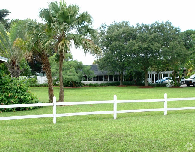
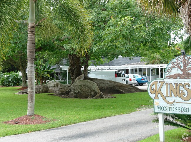
Property Record
20130 Sw 304Th St, Homestead, FL 33030

NEARBY LISTINGS FOR SALE OR LEASE
Property Detail
20130 Sw 304Th St
30-7810-000-0330
10 57 38 3.12 AC N1/2 OF NW1/4 OF NW1/4 OF SE1/4 LESS E165FT & LESS N35FT & W35FT FOR R/W COC 23184-3981 02 2005 4
Publichealthcarefacility
Miami/Dade
X
Florida
12086C0710L
3.12 AC
2024
South Dade
2025
South Florida
011500
Miami-Miami Beach-Kendall, FL
12,653 SF
DEMOGRAPHICS near 20130 Sw 304Th St
1 Mile
3 Mile
5 Mile
2024 Total Population
1,154
35,686
98,056
2029 Population
1,114
34,905
95,889
Pop Growth 2024-2029
(3.47%)
(2.19%)
(2.21%)
Average Age
39
35
36
2024 Total Households
338
10,221
28,801
HH Growth 2024-2029
(4.14%)
(2.61%)
(2.66%)
Median Household Inc
$96,919
$43,163
$50,299
Avg Household Size
3.30
3.30
3.20
2024 Avg HH Vehicles
3.00
2.00
2.00
Median Home Value
$412,931
$325,700
$326,357
Median Year Built
1999
1981
1991
Nearby Places
Map Layers
Map Styles
 Street
 Aerial
- Restaurants
- Banks
- Shops
- Fitness
- Groceries
PUBLIC TRANSPORTATION
AIRPORT
Miami International
DRIVE
WALK
Distance
Miami International
53 min
33.7 mi
Freight Ports
Port of Miami
DRIVE
WALK
Distance
Port of Miami
62 min
40.7 mi
Nearby Properties
Address
Land Use
TOTAL SIZE
Lot Size
Zoning
Address
Land Use
TOTAL SIZE
Lot Size
Zoning
122,719 SF
18.62 AC
9000
Address
Land Use
TOTAL SIZE
Lot Size
Zoning
169,474 SF
5.76 AC
6300
Address
Land Use
TOTAL SIZE
Lot Size
Zoning
208,951 SF
20 AC
6300
Address
Land Use
TOTAL SIZE
Lot Size
Zoning
35,830 SF
719.34 AC
8900
Address
Land Use
TOTAL SIZE
Lot Size
Zoning
431,236 SF
2.74 AC
9450
Address
Land Use
TOTAL SIZE
Lot Size
Zoning
102,707 SF
3.63 AC
9200
Address
Land Use
TOTAL SIZE
Lot Size
Zoning
49.95 AC
9300
Address
Land Use
TOTAL SIZE
Lot Size
Zoning
101,327 SF
0.69 AC
8000
Address
Land Use
TOTAL SIZE
Lot Size
Zoning
83,074 SF
5 AC
3000
Address
Land Use
TOTAL SIZE
Lot Size
Zoning
106,780 SF
1.33 AC
8000
Address
Land Use
TOTAL SIZE
Lot Size
Zoning
245,349 SF
10.88 AC
7000
Address
Land Use
TOTAL SIZE
Lot Size
Zoning
96,690 SF
5.83 AC
7000
Address
Land Use
TOTAL SIZE
Lot Size
Zoning
83,335 SF
2.06 AC
9450
Address
Land Use
TOTAL SIZE
Lot Size
Zoning
125,800 SF
10 AC
3000
Address
Land Use
TOTAL SIZE
Lot Size
Zoning
63,630 SF
0.14 AC
8000
Address
Land Use
TOTAL SIZE
Lot Size
Zoning
67,741 SF
10 AC
8000
Address
Land Use
TOTAL SIZE
Lot Size
Zoning
103,192 SF
4.30 AC
3000
Address
Land Use
TOTAL SIZE
Lot Size
Zoning
70,546 SF
1.42 AC
6300
Address
Land Use
TOTAL SIZE
Lot Size
Zoning
48,674 SF
3.39 AC
3000
Address
Land Use
TOTAL SIZE
Lot Size
Zoning
49,319 SF
4.64 AC
6300
Address
Land Use
TOTAL SIZE
Lot Size
Zoning
75,631 SF
4.80 AC
3000
Address
Land Use
TOTAL SIZE
Lot Size
Zoning
121,635 SF
7.10 AC
3000
Address
Land Use
TOTAL SIZE
Lot Size
Zoning
151,050 SF
8.74 AC
3000
Address
Land Use
TOTAL SIZE
Lot Size
Zoning
57,356 SF
2.33 AC
6300
Address
Land Use
TOTAL SIZE
Lot Size
Zoning
42,661 SF
5 AC
8000
Address
Land Use
TOTAL SIZE
Lot Size
Zoning
57,624 SF
0.41 AC
9450
Address
Land Use
TOTAL SIZE
Lot Size
Zoning
70,428 SF
3.75 AC
3000
Address
Land Use
TOTAL SIZE
Lot Size
Zoning
41,954 SF
9.53 AC
2200
The World's #1 Commercial Real Estate Marketplace
Connect with us
© 2026 CoStar Group
The information above has been obtained from sources believed reliable. While we do not doubt its accuracy we have not verified it and make no guarantee, warranty or representation about it. It is your responsibility to independently confirm its accuracy and completeness. Any projections, opinions, assumptions, or estimates used are for example only and do not represent the current or future performance of the property. The value of this transaction to you depends on tax and other factors which should be evaluated by your tax, financial, and legal advisors. You and your advisors should conduct a careful, independent investigation of the property to determine to your satisfaction the suitability of the property for your needs.