Property Record
20135 Lake Rd, Rocky River, OH 44116
Current Lease Availabilities
NEARBY LISTINGS FOR SALE OR LEASE
Property Detail
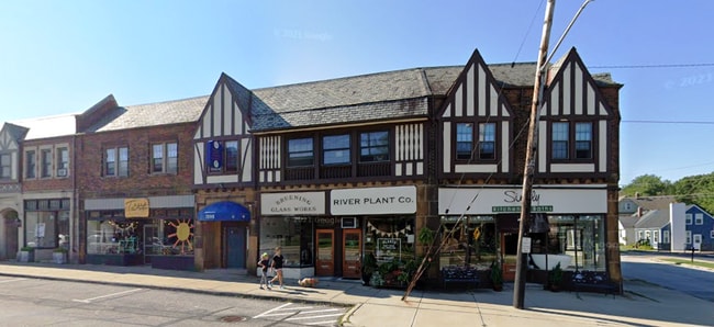
20135 Lake Rd
Cleveland-Elyria, OH
Beach Cliff Manor
301-16-008
24 BCLFMAN S/L 7 ALL 8 ALL 9 WP 0006 ALL
Retailwithmorethanonenonretailuse
Cuyahoga
X
Ohio
39035C0151F
6
2024
0.21 AC
2024
West
181100
Cleveland
15,751 SF
DEMOGRAPHICS near 20135 Lake Rd
1 Mile
3 Mile
5 Mile
2024 Total Population
10,210
76,132
191,323
2029 Population
9,886
73,843
185,664
Pop Growth 2024-2029
(3.17%)
(3.01%)
(2.96%)
Average Age
41
42
41
2024 Total Households
4,665
36,017
88,070
HH Growth 2024-2029
(3.41%)
(3.23%)
(3.10%)
Median Household Inc
$89,731
$72,051
$61,690
Avg Household Size
2.10
2.10
2.10
2024 Avg HH Vehicles
2.00
2.00
2.00
Median Home Value
$354,602
$241,240
$192,286
Median Year Built
1949
1949
1951
Nearby Places
Map Layers
Map Styles
 Street
 Aerial
- Restaurants
- Banks
- Shops
- Fitness
- Groceries
PUBLIC TRANSPORTATION
AIRPORT
Cleveland-Hopkins International
DRIVE
WALK
Distance
Cleveland-Hopkins International
16 min
6.2 mi
Freight Ports
Port of Toledo
DRIVE
WALK
Distance
Port of Toledo
125 min
104.5 mi
Nearby Properties
Address
Land Use
TOTAL SIZE
Lot Size
Zoning
Address
Land Use
TOTAL SIZE
Lot Size
Zoning
263,090 SF
33.53 AC
GB-A
Address
Land Use
TOTAL SIZE
Lot Size
Zoning
780,869 SF
14.77 AC
LR
Address
Land Use
TOTAL SIZE
Lot Size
Zoning
318,724 SF
41.71 AC
EI
Address
Land Use
TOTAL SIZE
Lot Size
Zoning
187 SF
20.90 AC
PG
Address
Land Use
TOTAL SIZE
Lot Size
Zoning
89,195 SF
1.58 AC
1F-R1
Address
Land Use
TOTAL SIZE
Lot Size
Zoning
518,244 SF
21.80 AC
Address
Land Use
TOTAL SIZE
Lot Size
Zoning
53,718 SF
2.19 AC
PF
Address
Land Use
TOTAL SIZE
Lot Size
Zoning
63,139 SF
1.52 AC
PF
Address
Land Use
TOTAL SIZE
Lot Size
Zoning
243,118 SF
15.01 AC
PF
Address
Land Use
TOTAL SIZE
Lot Size
Zoning
217,747 SF
29.07 AC
GB-A
Address
Land Use
TOTAL SIZE
Lot Size
Zoning
326,357 SF
6.40 AC
GB
Address
Land Use
TOTAL SIZE
Lot Size
Zoning
355,242 SF
13.28 AC
RMF-HR
Address
Land Use
TOTAL SIZE
Lot Size
Zoning
162,449 SF
23.90 AC
PF
Address
Land Use
TOTAL SIZE
Lot Size
Zoning
235,984 SF
18.10 AC
GB
Address
Land Use
TOTAL SIZE
Lot Size
Zoning
102,512 SF
5.17 AC
CR
Address
Land Use
TOTAL SIZE
Lot Size
Zoning
107,866 SF
11.22 AC
PF
Address
Land Use
TOTAL SIZE
Lot Size
Zoning
244,602 SF
10.31 AC
CR
Address
Land Use
TOTAL SIZE
Lot Size
Zoning
129,089 SF
19.21 AC
OB
Address
Land Use
TOTAL SIZE
Lot Size
Zoning
142,740 SF
1.83 AC
MF-2
Address
Land Use
TOTAL SIZE
Lot Size
Zoning
211,719 SF
18.82 AC
PF
Address
Land Use
TOTAL SIZE
Lot Size
Zoning
126,661 SF
7.07 AC
PD
Address
Land Use
TOTAL SIZE
Lot Size
Zoning
56,212 SF
2.69 AC
Address
Land Use
TOTAL SIZE
Lot Size
Zoning
278,256 SF
0.81 AC
C1
Address
Land Use
TOTAL SIZE
Lot Size
Zoning
154,906 SF
5.99 AC
GB
Address
Land Use
TOTAL SIZE
Lot Size
Zoning
64,000 SF
4.05 AC
Address
Land Use
TOTAL SIZE
Lot Size
Zoning
129,775 SF
10.05 AC
IS
Address
Land Use
TOTAL SIZE
Lot Size
Zoning
169,865 SF
28.66 AC
1F
Address
Land Use
TOTAL SIZE
Lot Size
Zoning
111,956 SF
210.37 AC
PP
Address
Land Use
TOTAL SIZE
Lot Size
Zoning
129,258 SF
13.35 AC
GB
Address
Land Use
TOTAL SIZE
Lot Size
Zoning
70,018 SF
6.43 AC
GA-R8
The World's #1 Commercial Real Estate Marketplace
Connect with us
© 2025 CoStar Group
The information above has been obtained from sources believed reliable. While we do not doubt its accuracy we have not verified it and make no guarantee, warranty or representation about it. It is your responsibility to independently confirm its accuracy and completeness. Any projections, opinions, assumptions, or estimates used are for example only and do not represent the current or future performance of the property. The value of this transaction to you depends on tax and other factors which should be evaluated by your tax, financial, and legal advisors. You and your advisors should conduct a careful, independent investigation of the property to determine to your satisfaction the suitability of the property for your needs.