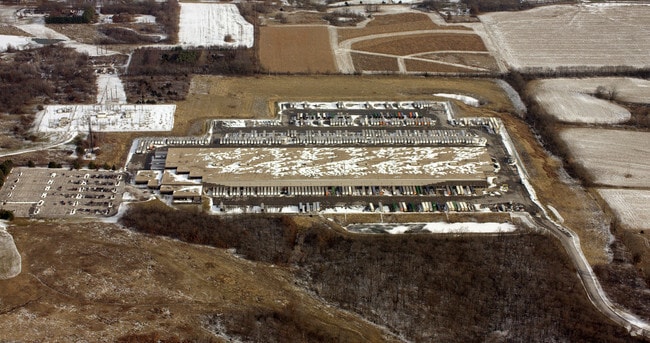
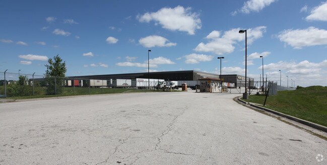
Property Record
2015 E Jefferson Rd, Grain Valley, MO 64029


Property Detail
2015 E Jefferson Rd
Kansas City, MO-KS
KOHLS DISTRIBUTION CENTER-LOT 1 1ST PLAT LOT 1
36-600-01-08-00-0-00-000
JACKSON
Shipyard
Missouri
B and X Area of moderate flood hazard, usually the area between the limits of the 100-year and 500-year floods.
1
2024
69.75 AC
2025
Blue Springs
014905
Kansas City
430,717 SF
NEARBY LISTINGS FOR SALE OR LEASE
DEMOGRAPHICS near 2015 E Jefferson Rd
1 mile
3 mile
5 mile
2025 Total Population
3,761
43,014
78,478
2030 Population
3,836
43,341
78,973
Pop Growth 2025-2030
+ 1.99%
+ 0.76%
+ 0.63%
Average Age
37
38
39
2025 Total Households
1,294
15,798
28,789
HH Growth 2025-2030
+ 2.09%
+ 0.75%
+ 0.61%
Median Household Inc
$109,259
$87,336
$88,956
Avg Household Size
2.80
2.70
2.70
2025 Avg HH Vehicles
2.00
2.00
2.00
Median Home Value
$343,043
$272,570
$275,264
Median Year Built
2002
1992
1989
Nearby Places
Map Layers
Map Styles
 Street
 Aerial
Layers
 Traffic
 Biking
Places
Listings with unknown addresses are not visible on the map
- Restaurants
- Banks
- Shops
- Fitness
- Groceries
Nearby Properties
Address
Land Use
TOTAL SIZE
Lot Size
Zoning
Address
Land Use
TOTAL SIZE
Lot Size
Zoning
292,760 SF
32.17 AC
Address
Land Use
TOTAL SIZE
Lot Size
Zoning
228,168 SF
25.12 AC
Address
Land Use
TOTAL SIZE
Lot Size
Zoning
584,820 SF
38 AC
Address
Land Use
TOTAL SIZE
Lot Size
Zoning
255,288 SF
25.67 AC
Address
Land Use
TOTAL SIZE
Lot Size
Zoning
28,639 SF
10.40 AC
Address
Land Use
TOTAL SIZE
Lot Size
Zoning
321,331 SF
55.69 AC
Address
Land Use
TOTAL SIZE
Lot Size
Zoning
127,621 SF
23 AC
Address
Land Use
TOTAL SIZE
Lot Size
Zoning
214,518 SF
22.16 AC
Address
Land Use
TOTAL SIZE
Lot Size
Zoning
71,169 SF
0.82 AC
Address
Land Use
TOTAL SIZE
Lot Size
Zoning
74,031 SF
0.02 AC
Address
Land Use
TOTAL SIZE
Lot Size
Zoning
96,371 SF
10.55 AC
Address
Land Use
TOTAL SIZE
Lot Size
Zoning
98,523 SF
9.48 AC
Address
Land Use
TOTAL SIZE
Lot Size
Zoning
42,176 SF
22.04 AC
Address
Land Use
TOTAL SIZE
Lot Size
Zoning
93,336 SF
11.67 AC
Address
Land Use
TOTAL SIZE
Lot Size
Zoning
80,458 SF
0.40 AC
Address
Land Use
TOTAL SIZE
Lot Size
Zoning
82,602 SF
8.80 AC
Address
Land Use
TOTAL SIZE
Lot Size
Zoning
98,600 SF
4.50 AC
Address
Land Use
TOTAL SIZE
Lot Size
Zoning
130,178 SF
10.25 AC
Address
Land Use
TOTAL SIZE
Lot Size
Zoning
67,986 SF
9.88 AC
Address
Land Use
TOTAL SIZE
Lot Size
Zoning
75,977 SF
8.86 AC
Address
Land Use
TOTAL SIZE
Lot Size
Zoning
36,000 SF
5.22 AC
Address
Land Use
TOTAL SIZE
Lot Size
Zoning
61,567 SF
10 AC
Address
Land Use
TOTAL SIZE
Lot Size
Zoning
110,829 SF
20.78 AC
Address
Land Use
TOTAL SIZE
Lot Size
Zoning
88,112 SF
8.31 AC
Address
Land Use
TOTAL SIZE
Lot Size
Zoning
53,384 SF
6.24 AC
Address
Land Use
TOTAL SIZE
Lot Size
Zoning
59,584 SF
4.44 AC
Address
Land Use
TOTAL SIZE
Lot Size
Zoning
95,342 SF
11.02 AC
Address
Land Use
TOTAL SIZE
Lot Size
Zoning
66,697 SF
2.97 AC
Address
Land Use
TOTAL SIZE
Lot Size
Zoning
137,347 SF
9.43 AC
The World's #1 Commercial Real Estate Marketplace
Connect with us
© 2026 CoStar Group
The information above has been obtained from sources believed reliable. While we do not doubt its accuracy we have not verified it and make no guarantee, warranty or representation about it. It is your responsibility to independently confirm its accuracy and completeness. Any projections, opinions, assumptions, or estimates used are for example only and do not represent the current or future performance of the property. The value of this transaction to you depends on tax and other factors which should be evaluated by your tax, financial, and legal advisors. You and your advisors should conduct a careful, independent investigation of the property to determine to your satisfaction the suitability of the property for your needs.