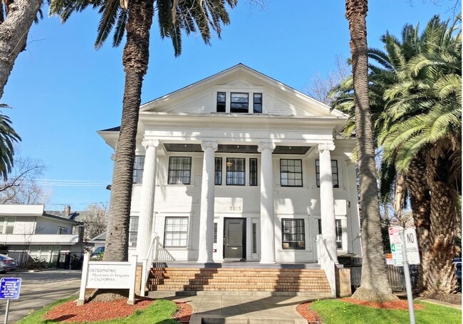
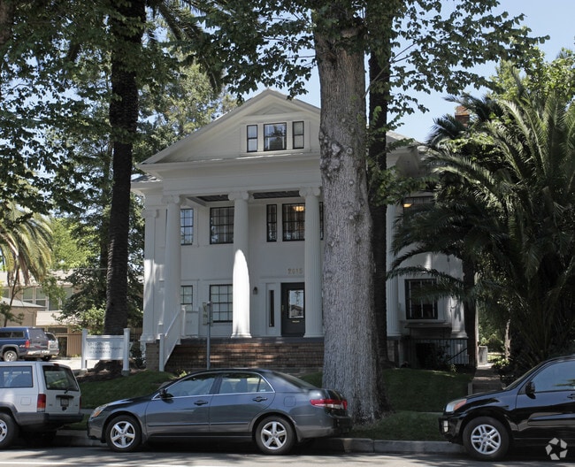
Property Record
2015 H St, Sacramento, CA 95811

Current Lease Availabilities
NEARBY LISTINGS FOR SALE OR LEASE
Property Detail
2015 H St
Sacramento--Roseville--Arden-Arcade, CA
Boulevard Park
003-0176-019
LOTS 3, 4 AND WLY 3 FT OF LOT 5, BOULEVARD PARK. CONTG 10,300SQ FT M/L.
Commercialnec
Sacramento
X
California
06067C0180J
3,4,5
2024
0.24 AC
2025
Midtown
000502
Sacramento
6,052 SF
DEMOGRAPHICS near 2015 H St
1 Mile
3 Mile
5 Mile
2024 Total Population
27,960
156,408
408,933
2029 Population
28,520
158,589
413,643
Pop Growth 2024-2029
+ 2.00%
+ 1.39%
+ 1.15%
Average Age
39
39
38
2024 Total Households
15,682
68,285
160,349
HH Growth 2024-2029
+ 2.30%
+ 1.60%
+ 1.28%
Median Household Inc
$67,448
$74,270
$67,648
Avg Household Size
1.60
2.10
2.40
2024 Avg HH Vehicles
1.00
1.00
2.00
Median Home Value
$707,689
$601,212
$461,222
Median Year Built
1961
1959
1968
Nearby Places
Map Layers
Map Styles
 Street
 Aerial
- Restaurants
- Banks
- Shops
- Fitness
- Groceries
PUBLIC TRANSPORTATION
COMMUTER RAIL
DRIVE
WALK
Distance
4 min
1.4 mi
AIRPORT
Sacramento International
DRIVE
WALK
Distance
Sacramento International
19 min
12.0 mi
Nearby Properties
Address
Land Use
TOTAL SIZE
Lot Size
Zoning
Address
Land Use
TOTAL SIZE
Lot Size
Zoning
1,095,507 SF
1.39 AC
H-SPD C-2-
Address
Land Use
TOTAL SIZE
Lot Size
Zoning
5.64 AC
C-3-SPD
Address
Land Use
TOTAL SIZE
Lot Size
Zoning
10.28 AC
H
Address
Land Use
TOTAL SIZE
Lot Size
Zoning
299,943 SF
4.95 AC
H
Address
Land Use
TOTAL SIZE
Lot Size
Zoning
487,483 SF
1.12 AC
C-3-SPD
Address
Land Use
TOTAL SIZE
Lot Size
Zoning
1.33 AC
R-1
Address
Land Use
TOTAL SIZE
Lot Size
Zoning
756,831 SF
1.39 AC
C-2-SPD
Address
Land Use
TOTAL SIZE
Lot Size
Zoning
399,626 SF
2.41 AC
C-3-SPD
Address
Land Use
TOTAL SIZE
Lot Size
Zoning
1.15 AC
R-1
Address
Land Use
TOTAL SIZE
Lot Size
Zoning
366,730 SF
0.89 AC
C-3-SPD
Address
Land Use
TOTAL SIZE
Lot Size
Zoning
200,616 SF
2.54 AC
C-2-SPD
Address
Land Use
TOTAL SIZE
Lot Size
Zoning
594,942 SF
2.39 AC
C-3-SPD
Address
Land Use
TOTAL SIZE
Lot Size
Zoning
676,447 SF
1.43 AC
C-3-SPD
Address
Land Use
TOTAL SIZE
Lot Size
Zoning
319,856 SF
12.27 AC
R-3-R-PUD
Address
Land Use
TOTAL SIZE
Lot Size
Zoning
193,521 SF
0.60 AC
C-3-SPD
Address
Land Use
TOTAL SIZE
Lot Size
Zoning
339,329 SF
6.40 AC
R-5-PUD-SP
Address
Land Use
TOTAL SIZE
Lot Size
Zoning
213,557 SF
2.33 AC
C-3-SPD
Address
Land Use
TOTAL SIZE
Lot Size
Zoning
226,731 SF
15.73 AC
OB-PUD
Address
Land Use
TOTAL SIZE
Lot Size
Zoning
0.65 AC
C-4-SPD
Address
Land Use
TOTAL SIZE
Lot Size
Zoning
467,970 SF
4.59 AC
W-F
Address
Land Use
TOTAL SIZE
Lot Size
Zoning
390,860 SF
20.17 AC
R-3-R-PUD
Address
Land Use
TOTAL SIZE
Lot Size
Zoning
410,420 SF
0.95 AC
C-3-SPD
Address
Land Use
TOTAL SIZE
Lot Size
Zoning
320,072 SF
2.65 AC
C-2
Address
Land Use
TOTAL SIZE
Lot Size
Zoning
R-4-PUD C-
Address
Land Use
TOTAL SIZE
Lot Size
Zoning
0.13 AC
WF
Address
Land Use
TOTAL SIZE
Lot Size
Zoning
26,712 SF
1.90 AC
R-5-PUD-SP
Address
Land Use
TOTAL SIZE
Lot Size
Zoning
26,712 SF
1.85 AC
R-5-PUD-SP
Address
Land Use
TOTAL SIZE
Lot Size
Zoning
2.88 AC
C-3-SPD
Address
Land Use
TOTAL SIZE
Lot Size
Zoning
508,916 SF
0.71 AC
C-3-SPD
Address
Land Use
TOTAL SIZE
Lot Size
Zoning
303,254 SF
10.63 AC
OB-PUD
The World's #1 Commercial Real Estate Marketplace
Connect with us
© 2025 CoStar Group
The information above has been obtained from sources believed reliable. While we do not doubt its accuracy we have not verified it and make no guarantee, warranty or representation about it. It is your responsibility to independently confirm its accuracy and completeness. Any projections, opinions, assumptions, or estimates used are for example only and do not represent the current or future performance of the property. The value of this transaction to you depends on tax and other factors which should be evaluated by your tax, financial, and legal advisors. You and your advisors should conduct a careful, independent investigation of the property to determine to your satisfaction the suitability of the property for your needs.