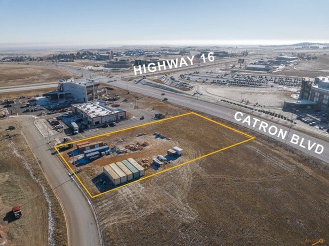
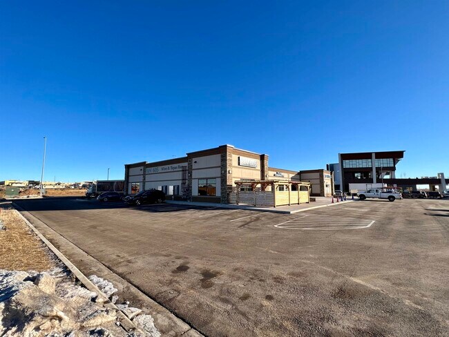
Property Record
2015 Hope Ct, Rapid City, SD 57701

Property Detail
2015 Hope Ct
Rapid City, SD
BUFFALO CROSSING WEST, LOT C
3727276005
PENNINGTON
Vacantlandnec
South Dakota
D Areas with possible but undetermined flood hazards.
c
2025
0.99 AC
2025
Rapid City
011004
Other Market Areas
NEARBY LISTINGS FOR SALE OR LEASE
DEMOGRAPHICS near 2015 Hope Ct
1 mile
3 mile
5 mile
2025 Total Population
2,415
20,972
55,628
2030 Population
2,499
21,870
57,866
Pop Growth 2025-2030
+ 3.48%
+ 4.28%
+ 4.02%
Average Age
42
44
42
2025 Total Households
1,104
8,704
23,570
HH Growth 2025-2030
+ 3.62%
+ 4.52%
+ 4.31%
Median Household Inc
$83,515
$97,225
$77,512
Avg Household Size
2.20
2.30
2.20
2025 Avg HH Vehicles
2.00
2.00
2.00
Median Home Value
$498,528
$438,577
$350,611
Median Year Built
2005
1996
1981
Nearby Places
Map Layers
Map Styles
 Street
 Aerial
Layers
 Traffic
 Biking
Places
Listings with unknown addresses are not visible on the map
- Restaurants
- Banks
- Shops
- Fitness
- Groceries
PUBLIC TRANSPORTATION
AIRPORT
Rapid City Regional
Drive
Walk
Distance
Rapid City Regional
21 min
13.3 mi
Freight Ports
Tulsa Port Of Catoosa
Drive
Walk
Distance
Tulsa Port Of Catoosa
974 min
894.0 mi
SALE & LEASE HISTORY
LISTING DATE
SALE/LEASE

Jan 15, 2023
For Lease
Nearby Properties
Address
Land Use
TOTAL SIZE
Lot Size
Zoning
Address
Land Use
TOTAL SIZE
Lot Size
Zoning
3,312 SF
27.57 AC
Address
Land Use
TOTAL SIZE
Lot Size
Zoning
19,728 SF
7.67 AC
Address
Land Use
TOTAL SIZE
Lot Size
Zoning
23,278 SF
9.23 AC
Address
Land Use
TOTAL SIZE
Lot Size
Zoning
9,294 SF
8.82 AC
Address
Land Use
TOTAL SIZE
Lot Size
Zoning
56,132 SF
7.14 AC
Address
Land Use
TOTAL SIZE
Lot Size
Zoning
4,759 SF
7.78 AC
Address
Land Use
TOTAL SIZE
Lot Size
Zoning
3,703 SF
8.46 AC
Address
Land Use
TOTAL SIZE
Lot Size
Zoning
12,258 SF
7.62 AC
Address
Land Use
TOTAL SIZE
Lot Size
Zoning
50,794 SF
7.05 AC
Address
Land Use
TOTAL SIZE
Lot Size
Zoning
12,464 SF
4.94 AC
Address
Land Use
TOTAL SIZE
Lot Size
Zoning
8,764 SF
6 AC
Address
Land Use
TOTAL SIZE
Lot Size
Zoning
2,058 SF
6.70 AC
Address
Land Use
TOTAL SIZE
Lot Size
Zoning
48,108 SF
38.14 AC
Address
Land Use
TOTAL SIZE
Lot Size
Zoning
24,360 SF
4.24 AC
Address
Land Use
TOTAL SIZE
Lot Size
Zoning
48,263 SF
7.28 AC
Address
Land Use
TOTAL SIZE
Lot Size
Zoning
25,762 SF
5.74 AC
Address
Land Use
TOTAL SIZE
Lot Size
Zoning
48,084 SF
5.74 AC
Address
Land Use
TOTAL SIZE
Lot Size
Zoning
17,392 SF
7.85 AC
Address
Land Use
TOTAL SIZE
Lot Size
Zoning
10,128 SF
2 AC
Address
Land Use
TOTAL SIZE
Lot Size
Zoning
164,294 SF
19 AC
Address
Land Use
TOTAL SIZE
Lot Size
Zoning
35,999 SF
3.01 AC
Address
Land Use
TOTAL SIZE
Lot Size
Zoning
37,888 SF
6.21 AC
Address
Land Use
TOTAL SIZE
Lot Size
Zoning
19,302 SF
4.74 AC
Address
Land Use
TOTAL SIZE
Lot Size
Zoning
21,722 SF
7.50 AC
Address
Land Use
TOTAL SIZE
Lot Size
Zoning
15,407 SF
4.83 AC
Address
Land Use
TOTAL SIZE
Lot Size
Zoning
38,026 SF
7.59 AC
Address
Land Use
TOTAL SIZE
Lot Size
Zoning
15,200 SF
2.37 AC
Address
Land Use
TOTAL SIZE
Lot Size
Zoning
8,901 SF
4.07 AC
Address
Land Use
TOTAL SIZE
Lot Size
Zoning
7,276 SF
2.22 AC
Address
Land Use
TOTAL SIZE
Lot Size
Zoning
7,276 SF
2.12 AC
The World's #1 Commercial Real Estate Marketplace
Connect with us
© 2026 CoStar Group
The information above has been obtained from sources believed reliable. While we do not doubt its accuracy we have not verified it and make no guarantee, warranty or representation about it. It is your responsibility to independently confirm its accuracy and completeness. Any projections, opinions, assumptions, or estimates used are for example only and do not represent the current or future performance of the property. The value of this transaction to you depends on tax and other factors which should be evaluated by your tax, financial, and legal advisors. You and your advisors should conduct a careful, independent investigation of the property to determine to your satisfaction the suitability of the property for your needs.