Property Record
2015 Mount Sharp Rd, Wimberley, TX 78676

Save to a Folder
{{folder.Name}}
{{folder.ListingIds.length}} Properties
{{folder.ListingIds.length}} Property
Create a New Folder
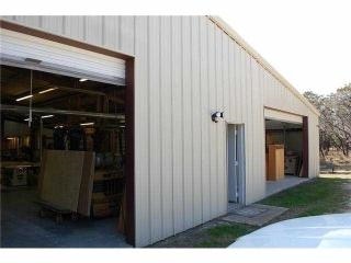
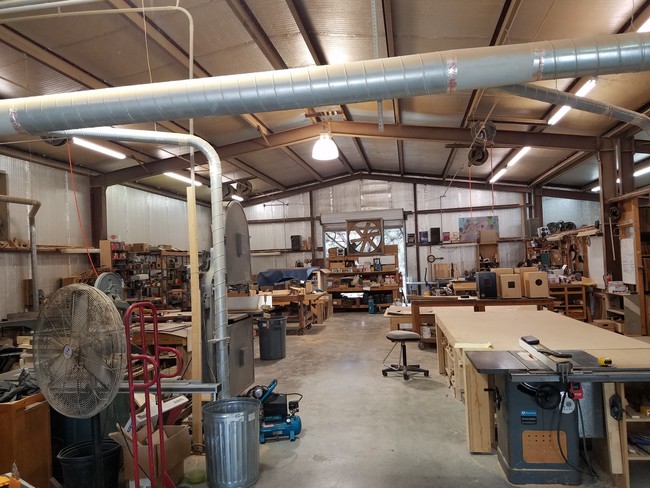
Property Detail
2015 Mount Sharp Rd
Austin-Round Rock-San Marcos, TX
COLEMAN CANYON RANCH SUBD, LOT 1, ACRES 5.00
R24466
Hays
Utilities
Texas
B and X Area of moderate flood hazard, usually the area between the limits of the 100-year and 500-year floods.
1
0
5 AC
2025
Hays County
010811
Austin
2,400 SF
NEARBY LISTINGS FOR SALE OR LEASE
-
-
View all Wimberley listings for sale on LoopNet.com
DEMOGRAPHICS near 2015 Mount Sharp Rd
1 mile
3 mile
5 mile
2025 Total Population
1,786
7,933
12,794
2030 Population
2,076
9,199
14,810
Pop Growth 2025-2030
+ 16.24%
+ 15.96%
+ 15.76%
Average Age
43
46
46
2025 Total Households
737
3,483
5,542
HH Growth 2025-2030
+ 17.37%
+ 17.11%
+ 16.94%
Median Household Inc
$75,789
$74,131
$82,539
Avg Household Size
2.40
2.30
2.30
2025 Avg HH Vehicles
2.00
2.00
2.00
Median Home Value
$428,294
$458,217
$503,297
Median Year Built
2005
2001
2001
Nearby Places
Map Layers
Map Styles
 Street
 Aerial
Layers
 Traffic
 Biking
Places
Listings with unknown addresses are not visible on the map
- Restaurants
- Banks
- Shops
- Fitness
- Groceries
PUBLIC TRANSPORTATION
AIRPORT
Austin-Bergstrom International
Drive
Walk
Distance
Austin-Bergstrom International
74 min
43.1 mi
SALE & LEASE HISTORY
LISTING DATE
SALE/LEASE

Jun 13, 2017
For Sale
Nearby Properties
Address
Land Use
TOTAL SIZE
Lot Size
Zoning
Address
Land Use
TOTAL SIZE
Lot Size
Zoning
60,385 SF
5.74 AC
Address
Land Use
TOTAL SIZE
Lot Size
Zoning
233.61 AC
Address
Land Use
TOTAL SIZE
Lot Size
Zoning
3,862 SF
2.20 AC
Address
Land Use
TOTAL SIZE
Lot Size
Zoning
8,202 SF
13.19 AC
Address
Land Use
TOTAL SIZE
Lot Size
Zoning
1,776 SF
11.62 AC
Address
Land Use
TOTAL SIZE
Lot Size
Zoning
720 SF
144.75 AC
Address
Land Use
TOTAL SIZE
Lot Size
Zoning
37.04 AC
Address
Land Use
TOTAL SIZE
Lot Size
Zoning
19.23 AC
Address
Land Use
TOTAL SIZE
Lot Size
Zoning
117.42 AC
Address
Land Use
TOTAL SIZE
Lot Size
Zoning
7,282 SF
15.87 AC
Address
Land Use
TOTAL SIZE
Lot Size
Zoning
800 SF
7.22 AC
Address
Land Use
TOTAL SIZE
Lot Size
Zoning
Address
Land Use
TOTAL SIZE
Lot Size
Zoning
10,460 SF
2.65 AC
Address
Land Use
TOTAL SIZE
Lot Size
Zoning
8,763 SF
21 AC
Address
Land Use
TOTAL SIZE
Lot Size
Zoning
1,080 SF
8.95 AC
Address
Land Use
TOTAL SIZE
Lot Size
Zoning
53.56 AC
Address
Land Use
TOTAL SIZE
Lot Size
Zoning
6,094 SF
10.83 AC
Address
Land Use
TOTAL SIZE
Lot Size
Zoning
3,328 SF
14.96 AC
Address
Land Use
TOTAL SIZE
Lot Size
Zoning
25,700 SF
4.47 AC
Address
Land Use
TOTAL SIZE
Lot Size
Zoning
1,344 SF
31.54 AC
Address
Land Use
TOTAL SIZE
Lot Size
Zoning
26,440 SF
5 AC
Address
Land Use
TOTAL SIZE
Lot Size
Zoning
Address
Land Use
TOTAL SIZE
Lot Size
Zoning
28.83 AC
Address
Land Use
TOTAL SIZE
Lot Size
Zoning
4,466 SF
16.07 AC
Address
Land Use
TOTAL SIZE
Lot Size
Zoning
Address
Land Use
TOTAL SIZE
Lot Size
Zoning
3,376 SF
181.96 AC
Address
Land Use
TOTAL SIZE
Lot Size
Zoning
4,876 SF
22.70 AC
Address
Land Use
TOTAL SIZE
Lot Size
Zoning
9,728 SF
30 AC
Address
Land Use
TOTAL SIZE
Lot Size
Zoning
5,561 SF
5.73 AC
Address
Land Use
TOTAL SIZE
Lot Size
Zoning
30,290 SF
6.15 AC
The World's #1 Commercial Real Estate Marketplace
Connect with us
© 2026 CoStar Group
The information above has been obtained from sources believed reliable. While we do not doubt its accuracy we have not verified it and make no guarantee, warranty or representation about it. It is your responsibility to independently confirm its accuracy and completeness. Any projections, opinions, assumptions, or estimates used are for example only and do not represent the current or future performance of the property. The value of this transaction to you depends on tax and other factors which should be evaluated by your tax, financial, and legal advisors. You and your advisors should conduct a careful, independent investigation of the property to determine to your satisfaction the suitability of the property for your needs.