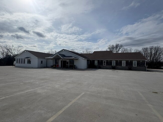
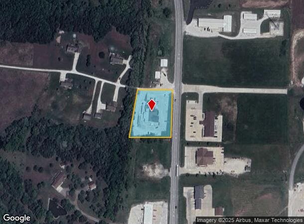
Property Record
2015 N Missouri St, Macon, MO 63552

NEARBY LISTINGS FOR SALE OR LEASE
-
-
View all Macon listings for sale on LoopNet.com
Property Detail
2015 N Missouri St
075819-0209-00000-001403
Bell Subd
Storemultistory
BEG 541.6' N OF NE COR LOT 3 OF BELL SUBD, W 192.4' TO RR, NLY 270' M/L, E TO HWY, S TO POB
X
Macon
29121C0339C
Missouri
2024
3
2025
1.52 AC
960400
Missouri North Area
6,446 SF
Other Market Areas
DEMOGRAPHICS near 2015 N Missouri St
1 Mile
3 Mile
5 Mile
2024 Total Population
1,179
5,989
6,835
2029 Population
1,142
5,852
6,678
Pop Growth 2024-2029
(3.14%)
(2.29%)
(2.30%)
Average Age
44
42
43
2024 Total Households
520
2,592
2,951
HH Growth 2024-2029
(3.08%)
(2.12%)
(2.10%)
Median Household Inc
$49,999
$46,804
$47,461
Avg Household Size
2.20
2.20
2.20
2024 Avg HH Vehicles
2.00
2.00
2.00
Median Home Value
$156,343
$128,404
$133,913
Median Year Built
1973
1970
1970
Nearby Places
- Restaurants
- Banks
- Shops
- Fitness
- Groceries
SALE & LEASE HISTORY
LISTING DATE
SALE/LEASE

Mar 04, 2025
For Sale
Nearby Properties
Address
Land Use
TOTAL SIZE
Lot Size
Zoning
Address
Land Use
TOTAL SIZE
Lot Size
Zoning
107,925 SF
5.18 AC
Address
Land Use
TOTAL SIZE
Lot Size
Zoning
16,936 SF
13.98 AC
Address
Land Use
TOTAL SIZE
Lot Size
Zoning
4,800 SF
1.43 AC
Address
Land Use
TOTAL SIZE
Lot Size
Zoning
5,000 SF
7.72 AC
Address
Land Use
TOTAL SIZE
Lot Size
Zoning
34,831 SF
27.85 AC
Address
Land Use
TOTAL SIZE
Lot Size
Zoning
19,888 SF
4.77 AC
Address
Land Use
TOTAL SIZE
Lot Size
Zoning
6,438 SF
27.70 AC
Address
Land Use
TOTAL SIZE
Lot Size
Zoning
2,448 SF
114.20 AC
Address
Land Use
TOTAL SIZE
Lot Size
Zoning
22,472 SF
13.45 AC
Address
Land Use
TOTAL SIZE
Lot Size
Zoning
60,515 SF
2.83 AC
Address
Land Use
TOTAL SIZE
Lot Size
Zoning
5,400 SF
1.05 AC
Address
Land Use
TOTAL SIZE
Lot Size
Zoning
7,558 SF
3.51 AC
Address
Land Use
TOTAL SIZE
Lot Size
Zoning
2,400 SF
32 AC
Address
Land Use
TOTAL SIZE
Lot Size
Zoning
5,462 SF
0.85 AC
Address
Land Use
TOTAL SIZE
Lot Size
Zoning
2,304 SF
8.36 AC
Address
Land Use
TOTAL SIZE
Lot Size
Zoning
9,216 SF
2.24 AC
Address
Land Use
TOTAL SIZE
Lot Size
Zoning
27,147 SF
6.23 AC
Address
Land Use
TOTAL SIZE
Lot Size
Zoning
2,621 SF
0.28 AC
Address
Land Use
TOTAL SIZE
Lot Size
Zoning
4,481 SF
129 AC
Address
Land Use
TOTAL SIZE
Lot Size
Zoning
8,492 SF
1.99 AC
Address
Land Use
TOTAL SIZE
Lot Size
Zoning
5,470 SF
1.01 AC
Address
Land Use
TOTAL SIZE
Lot Size
Zoning
10,620 SF
23.71 AC
Address
Land Use
TOTAL SIZE
Lot Size
Zoning
15,102 SF
3.35 AC
Address
Land Use
TOTAL SIZE
Lot Size
Zoning
6,111 SF
5.54 AC
Address
Land Use
TOTAL SIZE
Lot Size
Zoning
7,251 SF
0.82 AC
Address
Land Use
TOTAL SIZE
Lot Size
Zoning
3,050 SF
0.09 AC
Address
Land Use
TOTAL SIZE
Lot Size
Zoning
13,121 SF
2.70 AC
Address
Land Use
TOTAL SIZE
Lot Size
Zoning
4,620 SF
0.98 AC
Address
Land Use
TOTAL SIZE
Lot Size
Zoning
3,680 SF
6.25 AC
Address
Land Use
TOTAL SIZE
Lot Size
Zoning
5,040 SF
0.69 AC
The World's #1 Commercial Real Estate Marketplace
Connect with us
© 2025 CoStar Group
The information above has been obtained from sources believed reliable. While we do not doubt its accuracy we have not verified it and make no guarantee, warranty or representation about it. It is your responsibility to independently confirm its accuracy and completeness. Any projections, opinions, assumptions, or estimates used are for example only and do not represent the current or future performance of the property. The value of this transaction to you depends on tax and other factors which should be evaluated by your tax, financial, and legal advisors. You and your advisors should conduct a careful, independent investigation of the property to determine to your satisfaction the suitability of the property for your needs.