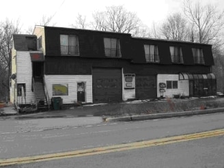
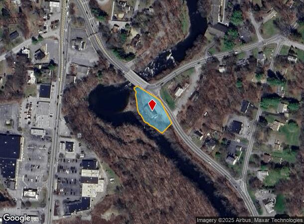
Property Record
2015 New Hackensack Rd, Poughkeepsie, NY 12603
NEARBY LISTINGS FOR SALE OR LEASE
Property Detail
2015 New Hackensack Rd
133400-6260-04-572274-0000
1.0 AC (C) 1487 0729 1296 0385
Autorepair
Dutchess
AE
New York
36027C0388E
572
2025
1 AC
2024
Fishkill
080201
Westchester/So Connecticut
6,276 SF
Dutchess County-Putnam County, NY
DEMOGRAPHICS near 2015 New Hackensack Rd
1 Mile
3 Mile
5 Mile
2024 Total Population
4,676
32,524
102,826
2029 Population
4,675
32,546
102,922
Pop Growth 2024-2029
(0.02%)
+ 0.07%
+ 0.09%
Average Age
43
41
41
2024 Total Households
1,690
11,248
39,585
HH Growth 2024-2029
(0.06%)
+ 0.04%
+ 0.14%
Median Household Inc
$114,732
$116,698
$81,689
Avg Household Size
2.70
2.60
2.40
2024 Avg HH Vehicles
2.00
2.00
2.00
Median Home Value
$335,276
$347,112
$326,727
Median Year Built
1960
1966
1965
Nearby Places
- Restaurants
- Banks
- Shops
- Fitness
- Groceries
PUBLIC TRANSPORTATION
COMMUTER RAIL
New Hamburg Station (Hudson Line - Metro-North Commuter Railroad Company (Metro-North))
DRIVE
WALK
Distance
New Hamburg Station (Hudson Line - Metro-North Commuter Railroad Company (Metro-North))
16 min
6.7 mi
Poughkeepsie Station (Hudson Line - Metro-North Commuter Railroad Company (Metro-North))
DRIVE
WALK
Distance
Poughkeepsie Station (Hudson Line - Metro-North Commuter Railroad Company (Metro-North))
11 min
6.8 mi
AIRPORT
New York Stewart International
DRIVE
WALK
Distance
New York Stewart International
40 min
23.8 mi
Nearby Properties
Address
Land Use
TOTAL SIZE
Lot Size
Zoning
Address
Land Use
TOTAL SIZE
Lot Size
Zoning
1,279,884 SF
255.89 AC
IN
Address
Land Use
TOTAL SIZE
Lot Size
Zoning
127,976 SF
6.57 AC
OR
Address
Land Use
TOTAL SIZE
Lot Size
Zoning
179,351 SF
18.34 AC
IN
Address
Land Use
TOTAL SIZE
Lot Size
Zoning
121,040 SF
16.05 AC
OPD
Address
Land Use
TOTAL SIZE
Lot Size
Zoning
126,616 SF
25.57 AC
R20
Address
Land Use
TOTAL SIZE
Lot Size
Zoning
30,420 SF
11.30 AC
R-2
Address
Land Use
TOTAL SIZE
Lot Size
Zoning
31,608 SF
57 AC
IN
Address
Land Use
TOTAL SIZE
Lot Size
Zoning
56,477 SF
38.98 AC
IN
Address
Land Use
TOTAL SIZE
Lot Size
Zoning
6.24 AC
I
Address
Land Use
TOTAL SIZE
Lot Size
Zoning
6.70 AC
R-1.5A
Address
Land Use
TOTAL SIZE
Lot Size
Zoning
101,527 SF
13 AC
ATC
Address
Land Use
TOTAL SIZE
Lot Size
Zoning
114,443 SF
43.60 AC
IN
Address
Land Use
TOTAL SIZE
Lot Size
Zoning
65,458 SF
11.60 AC
RFD
Address
Land Use
TOTAL SIZE
Lot Size
Zoning
92,574 SF
9.31 AC
BH
Address
Land Use
TOTAL SIZE
Lot Size
Zoning
70,830 SF
23.68 AC
R20
Address
Land Use
TOTAL SIZE
Lot Size
Zoning
160,214 SF
17.47 AC
R20
Address
Land Use
TOTAL SIZE
Lot Size
Zoning
512,000 SF
67 AC
AI
Address
Land Use
TOTAL SIZE
Lot Size
Zoning
52,807 SF
10.87 AC
R20
Address
Land Use
TOTAL SIZE
Lot Size
Zoning
510.80 AC
AI
Address
Land Use
TOTAL SIZE
Lot Size
Zoning
106,850 SF
17.80 AC
R20
Address
Land Use
TOTAL SIZE
Lot Size
Zoning
3.24 AC
IN
Address
Land Use
TOTAL SIZE
Lot Size
Zoning
59,409 SF
34.17 AC
R20
Address
Land Use
TOTAL SIZE
Lot Size
Zoning
125,202 SF
11.20 AC
RMF5
Address
Land Use
TOTAL SIZE
Lot Size
Zoning
102,184 SF
24.28 AC
IN
Address
Land Use
TOTAL SIZE
Lot Size
Zoning
46,672 SF
24.43 AC
R20
Address
Land Use
TOTAL SIZE
Lot Size
Zoning
85,160 SF
20 AC
RFD
Address
Land Use
TOTAL SIZE
Lot Size
Zoning
90,129 SF
2.90 AC
BH
Address
Land Use
TOTAL SIZE
Lot Size
Zoning
115,384 SF
3.59 AC
BH
Address
Land Use
TOTAL SIZE
Lot Size
Zoning
50,900 SF
19 AC
R20
Address
Land Use
TOTAL SIZE
Lot Size
Zoning
62,452 SF
3 AC
R20
The World's #1 Commercial Real Estate Marketplace
Connect with us
© 2025 CoStar Group
The information above has been obtained from sources believed reliable. While we do not doubt its accuracy we have not verified it and make no guarantee, warranty or representation about it. It is your responsibility to independently confirm its accuracy and completeness. Any projections, opinions, assumptions, or estimates used are for example only and do not represent the current or future performance of the property. The value of this transaction to you depends on tax and other factors which should be evaluated by your tax, financial, and legal advisors. You and your advisors should conduct a careful, independent investigation of the property to determine to your satisfaction the suitability of the property for your needs.