Property Record
2015 Olivera Ave, Arroyo Grande, CA 93420
NEARBY LISTINGS FOR SALE OR LEASE
-
-
View all Arroyo Grande listings for sale on LoopNet.com
Property Detail
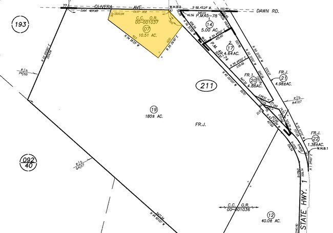
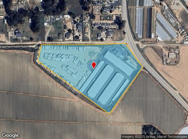
2015 Olivera Ave
San Luis Obispo-Paso Robles-Arroyo Grande, CA
Los Berros
091-211-007
RHO NIP LS BERROS TR PTN LT J
Shipyard
San Luis Obispo
X
California
06079C1615H
j
2024
10.51 AC
2025
South 101 Corridor
012306
San Luis Obispo/Paso Robles
124,604 SF
DEMOGRAPHICS near 2015 Olivera Ave
1 Mile
3 Mile
5 Mile
2024 Total Population
1,278
9,406
29,096
2029 Population
1,260
9,283
28,703
Pop Growth 2024-2029
(1.41%)
(1.31%)
(1.35%)
Average Age
51
52
45
2024 Total Households
517
3,892
10,825
HH Growth 2024-2029
(1.35%)
(1.34%)
(1.50%)
Median Household Inc
$134,077
$122,263
$89,311
Avg Household Size
2.40
2.30
2.60
2024 Avg HH Vehicles
2.00
2.00
2.00
Median Home Value
$860,878
$837,535
$724,080
Median Year Built
2004
2000
1987
Nearby Places
Map Layers
Map Styles
 Street
 Aerial
- Restaurants
- Banks
- Shops
- Fitness
- Groceries
PUBLIC TRANSPORTATION
COMMUTER RAIL
Guadalupe Amtrak Station (Pacific Surfliner - Amtrak)
DRIVE
WALK
Distance
Guadalupe Amtrak Station (Pacific Surfliner - Amtrak)
8 min
5.7 mi
Grover Beach Amtrak (Pacific Surfliner - Amtrak)
DRIVE
WALK
Distance
Grover Beach Amtrak (Pacific Surfliner - Amtrak)
15 min
8.9 mi
AIRPORT
San Luis County Regional
DRIVE
WALK
Distance
San Luis County Regional
29 min
17.6 mi
Freight Ports
The Port of Hueneme
DRIVE
WALK
Distance
The Port of Hueneme
150 min
115.4 mi
Nearby Properties
Address
Land Use
TOTAL SIZE
Lot Size
Zoning
Address
Land Use
TOTAL SIZE
Lot Size
Zoning
46,998 SF
564 AC
IND
Address
Land Use
TOTAL SIZE
Lot Size
Zoning
43.16 AC
RR
Address
Land Use
TOTAL SIZE
Lot Size
Zoning
71.70 AC
RR
Address
Land Use
TOTAL SIZE
Lot Size
Zoning
39.09 AC
RR
Address
Land Use
TOTAL SIZE
Lot Size
Zoning
87,964 SF
4.67 AC
IND
Address
Land Use
TOTAL SIZE
Lot Size
Zoning
47,500 SF
AG
Address
Land Use
TOTAL SIZE
Lot Size
Zoning
253.32 AC
AG
Address
Land Use
TOTAL SIZE
Lot Size
Zoning
216.60 AC
AG
Address
Land Use
TOTAL SIZE
Lot Size
Zoning
31,790 SF
2.28 AC
CS
Address
Land Use
TOTAL SIZE
Lot Size
Zoning
47,041 SF
8.98 AC
IND
Address
Land Use
TOTAL SIZE
Lot Size
Zoning
90.50 AC
RR
Address
Land Use
TOTAL SIZE
Lot Size
Zoning
301 AC
AG
Address
Land Use
TOTAL SIZE
Lot Size
Zoning
194.65 AC
AG
Address
Land Use
TOTAL SIZE
Lot Size
Zoning
2,520 SF
39.20 AC
RR
Address
Land Use
TOTAL SIZE
Lot Size
Zoning
19.51 AC
Address
Land Use
TOTAL SIZE
Lot Size
Zoning
228 AC
AG
Address
Land Use
TOTAL SIZE
Lot Size
Zoning
0.01 AC
IND
Address
Land Use
TOTAL SIZE
Lot Size
Zoning
19,200 SF
1.24 AC
IND
Address
Land Use
TOTAL SIZE
Lot Size
Zoning
286 AC
AG
Address
Land Use
TOTAL SIZE
Lot Size
Zoning
20.78 AC
RR
Address
Land Use
TOTAL SIZE
Lot Size
Zoning
179.09 AC
AG
Address
Land Use
TOTAL SIZE
Lot Size
Zoning
76,234 SF
4.67 AC
IND
Address
Land Use
TOTAL SIZE
Lot Size
Zoning
41,952 SF
2.38 AC
IND
Address
Land Use
TOTAL SIZE
Lot Size
Zoning
4,544 SF
55.75 AC
AG
Address
Land Use
TOTAL SIZE
Lot Size
Zoning
119 AC
AG
Address
Land Use
TOTAL SIZE
Lot Size
Zoning
31.50 AC
RR
Address
Land Use
TOTAL SIZE
Lot Size
Zoning
1.28 AC
Address
Land Use
TOTAL SIZE
Lot Size
Zoning
109.35 AC
AG
Address
Land Use
TOTAL SIZE
Lot Size
Zoning
40 AC
RR
The World's #1 Commercial Real Estate Marketplace
Connect with us
© 2026 CoStar Group
The information above has been obtained from sources believed reliable. While we do not doubt its accuracy we have not verified it and make no guarantee, warranty or representation about it. It is your responsibility to independently confirm its accuracy and completeness. Any projections, opinions, assumptions, or estimates used are for example only and do not represent the current or future performance of the property. The value of this transaction to you depends on tax and other factors which should be evaluated by your tax, financial, and legal advisors. You and your advisors should conduct a careful, independent investigation of the property to determine to your satisfaction the suitability of the property for your needs.