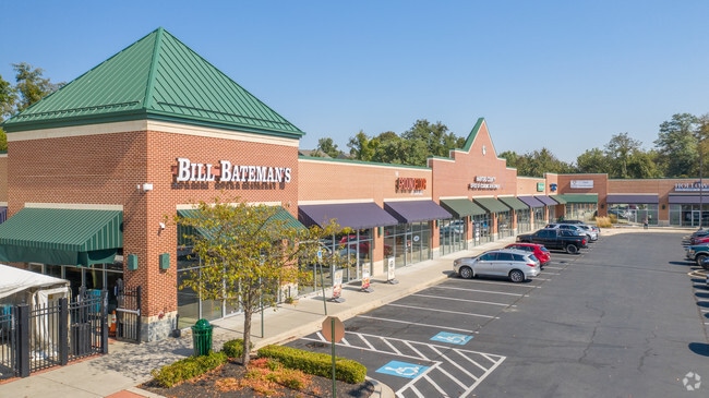
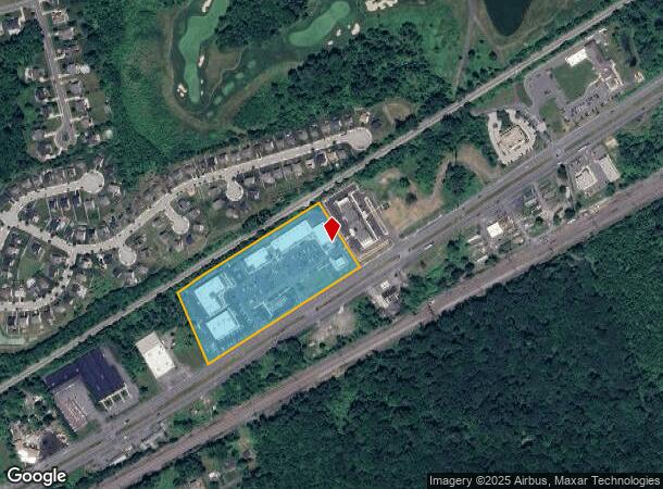
Property Record
2015 Pulaski Hwy, Havre De Grace, MD 21078

NEARBY LISTINGS FOR SALE OR LEASE
Property Detail
2015 Pulaski Hwy
Baltimore-Columbia-Towson, MD
Pulaski Highway Vilg Swan Creek
06-003842
LOT 1 9.51 AC 2015 PULASKI HIGHWAY VILG SWAN CREEK 121/99
Communitycenter
Harford
X
Maryland
24025C0194E
1
2025
9.51 AC
2025
Aberdeen
306300
Baltimore
29,700 SF
DEMOGRAPHICS near 2015 Pulaski Hwy
1 Mile
3 Mile
5 Mile
2024 Total Population
2,976
33,961
49,351
2029 Population
3,113
35,327
51,416
Pop Growth 2024-2029
+ 4.60%
+ 4.02%
+ 4.18%
Average Age
44
42
42
2024 Total Households
1,120
13,699
19,863
HH Growth 2024-2029
+ 4.64%
+ 4.06%
+ 4.21%
Median Household Inc
$120,637
$83,557
$81,569
Avg Household Size
2.60
2.40
2.40
2024 Avg HH Vehicles
2.00
2.00
2.00
Median Home Value
$327,848
$274,042
$280,081
Median Year Built
2000
1983
1983
Nearby Places
Map Layers
Map Styles
 Street
 Aerial
- Restaurants
- Banks
- Shops
- Fitness
- Groceries
PUBLIC TRANSPORTATION
COMMUTER RAIL
Aberdeen (PENN - WASHINGTON - Maryland Area Regional Commuter Trains (The MARC), Penn Line - Maryland Area Regional Commuter Trains (The MARC))
DRIVE
WALK
Distance
Aberdeen (PENN - WASHINGTON - Maryland Area Regional Commuter Trains (The MARC), Penn Line - Maryland Area Regional Commuter Trains (The MARC))
5 min
2.6 mi
Perryville (PENN - WASHINGTON - Maryland Area Regional Commuter Trains (The MARC), Penn Line - Maryland Area Regional Commuter Trains (The MARC))
DRIVE
WALK
Distance
Perryville (PENN - WASHINGTON - Maryland Area Regional Commuter Trains (The MARC), Penn Line - Maryland Area Regional Commuter Trains (The MARC))
9 min
5.4 mi
Freight Ports
Port of Baltimore
DRIVE
WALK
Distance
Port of Baltimore
48 min
35.5 mi
SALE & LEASE HISTORY
LISTING DATE
SALE/LEASE

Sep 25, 2016
For Lease
Nearby Properties
Address
Land Use
TOTAL SIZE
Lot Size
Zoning
Address
Land Use
TOTAL SIZE
Lot Size
Zoning
2,589 SF
57.19 AC
R2
Address
Land Use
TOTAL SIZE
Lot Size
Zoning
197,582 SF
63.43 AC
R1
Address
Land Use
TOTAL SIZE
Lot Size
Zoning
257,922 SF
34.94 AC
B3
Address
Land Use
TOTAL SIZE
Lot Size
Zoning
623,017 SF
57.87 AC
GI
Address
Land Use
TOTAL SIZE
Lot Size
Zoning
399,600 SF
23.91 AC
M1
Address
Land Use
TOTAL SIZE
Lot Size
Zoning
180,905 SF
26.46 AC
R2
Address
Land Use
TOTAL SIZE
Lot Size
Zoning
37,951 SF
148.22 AC
AG
Address
Land Use
TOTAL SIZE
Lot Size
Zoning
132,676 SF
4.40 AC
M1
Address
Land Use
TOTAL SIZE
Lot Size
Zoning
644,292 SF
46.97 AC
GI
Address
Land Use
TOTAL SIZE
Lot Size
Zoning
13,376 SF
14.49 AC
R1
Address
Land Use
TOTAL SIZE
Lot Size
Zoning
149,622 SF
9.30 AC
GI
Address
Land Use
TOTAL SIZE
Lot Size
Zoning
346,820 SF
25.12 AC
I
Address
Land Use
TOTAL SIZE
Lot Size
Zoning
100,444 SF
2.64 AC
RB
Address
Land Use
TOTAL SIZE
Lot Size
Zoning
113,412 SF
108 AC
R2
Address
Land Use
TOTAL SIZE
Lot Size
Zoning
426,275 SF
21.17 AC
GI
Address
Land Use
TOTAL SIZE
Lot Size
Zoning
96,518 SF
9.09 AC
B3
Address
Land Use
TOTAL SIZE
Lot Size
Zoning
52,917 SF
17.61 AC
B3
Address
Land Use
TOTAL SIZE
Lot Size
Zoning
58,603 SF
13.26 AC
R1
Address
Land Use
TOTAL SIZE
Lot Size
Zoning
82,398 SF
4.78 AC
B3
Address
Land Use
TOTAL SIZE
Lot Size
Zoning
1,270 SF
61.42 AC
C
Address
Land Use
TOTAL SIZE
Lot Size
Zoning
213,790 SF
1.37 AC
RB
Address
Land Use
TOTAL SIZE
Lot Size
Zoning
63,379 SF
3.05 AC
B3
Address
Land Use
TOTAL SIZE
Lot Size
Zoning
42,000 SF
13.40 AC
B3
Address
Land Use
TOTAL SIZE
Lot Size
Zoning
104,940 SF
6.33 AC
B3
Address
Land Use
TOTAL SIZE
Lot Size
Zoning
184,116 SF
18.45 AC
GI
Address
Land Use
TOTAL SIZE
Lot Size
Zoning
78,944 SF
18.78 AC
GI
Address
Land Use
TOTAL SIZE
Lot Size
Zoning
72,197 SF
28.36 AC
R2
Address
Land Use
TOTAL SIZE
Lot Size
Zoning
18,944 SF
7.11 AC
GI
Address
Land Use
TOTAL SIZE
Lot Size
Zoning
103,910 SF
6.47 AC
R3
The World's #1 Commercial Real Estate Marketplace
Connect with us
© 2026 CoStar Group
The information above has been obtained from sources believed reliable. While we do not doubt its accuracy we have not verified it and make no guarantee, warranty or representation about it. It is your responsibility to independently confirm its accuracy and completeness. Any projections, opinions, assumptions, or estimates used are for example only and do not represent the current or future performance of the property. The value of this transaction to you depends on tax and other factors which should be evaluated by your tax, financial, and legal advisors. You and your advisors should conduct a careful, independent investigation of the property to determine to your satisfaction the suitability of the property for your needs.