Property Record
20156 Stanton Ave, Castro Valley, CA 94546


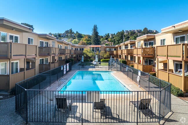
Property Detail
20156 Stanton Ave
Oakland-Fremont-Berkeley, CA
LOT: 00004 BLK: AR: 084A PAGE: 0279
084A-0279-004-00
Alameda
Multifamilydwelling
California
B and X Area of moderate flood hazard, usually the area between the limits of the 100-year and 500-year floods.
17
2024
1.61 AC
2025
East Outer Fremont
430900
East Bay/Oakland
47,806 SF
NEARBY LISTINGS FOR SALE OR LEASE
DEMOGRAPHICS near 20156 Stanton Ave
1 mile
3 mile
5 mile
2025 Total Population
27,047
191,841
359,906
2030 Population
26,921
190,952
358,240
Pop Growth 2025-2030
(0.47%)
(0.46%)
(0.46%)
Average Age
41
40
41
2025 Total Households
9,630
64,303
117,996
HH Growth 2025-2030
(0.59%)
(0.55%)
(0.56%)
Median Household Inc
$106,096
$103,966
$107,632
Avg Household Size
2.70
2.90
2.90
2025 Avg HH Vehicles
2.00
2.00
2.00
Median Home Value
$896,354
$841,034
$828,585
Median Year Built
1962
1965
1965
Nearby Places
Map Layers
Map Styles
 Street
 Aerial
Layers
 Traffic
 Biking
Places
Listings with unknown addresses are not visible on the map
- Restaurants
- Banks
- Shops
- Fitness
- Groceries
PUBLIC TRANSPORTATION
COMMUTER RAIL
Drive
Walk
Distance
8 min
3.2 mi
Drive
Walk
Distance
8 min
3.2 mi
AIRPORT
Metro Oakland International
Drive
Walk
Distance
Metro Oakland International
14 min
9.6 mi
San Francisco International
Drive
Walk
Distance
San Francisco International
36 min
25.3 mi
Norman Y Mineta San Jose International
Drive
Walk
Distance
Norman Y Mineta San Jose International
40 min
29.9 mi
Freight Ports
Port of Oakland
Drive
Walk
Distance
Port of Oakland
19 min
14.1 mi
Nearby Properties
Address
Land Use
TOTAL SIZE
Lot Size
Zoning
Address
Land Use
TOTAL SIZE
Lot Size
Zoning
4.90 AC
Address
Land Use
TOTAL SIZE
Lot Size
Zoning
437,104 SF
0.73 AC
Address
Land Use
TOTAL SIZE
Lot Size
Zoning
2.48 AC
Address
Land Use
TOTAL SIZE
Lot Size
Zoning
470,929 SF
31.62 AC
Address
Land Use
TOTAL SIZE
Lot Size
Zoning
1.50 AC
Address
Land Use
TOTAL SIZE
Lot Size
Zoning
187,926 SF
1.19 AC
Address
Land Use
TOTAL SIZE
Lot Size
Zoning
294,146 SF
14.22 AC
Address
Land Use
TOTAL SIZE
Lot Size
Zoning
241,382 SF
12.72 AC
Address
Land Use
TOTAL SIZE
Lot Size
Zoning
297,592 SF
11.65 AC
Address
Land Use
TOTAL SIZE
Lot Size
Zoning
310,072 SF
14.96 AC
Address
Land Use
TOTAL SIZE
Lot Size
Zoning
228,736 SF
5.95 AC
Address
Land Use
TOTAL SIZE
Lot Size
Zoning
169,371 SF
4.63 AC
Address
Land Use
TOTAL SIZE
Lot Size
Zoning
625,101 SF
35.95 AC
Address
Land Use
TOTAL SIZE
Lot Size
Zoning
116,750 SF
4.72 AC
Address
Land Use
TOTAL SIZE
Lot Size
Zoning
105,730 SF
5.32 AC
Address
Land Use
TOTAL SIZE
Lot Size
Zoning
140,850 SF
9.98 AC
Address
Land Use
TOTAL SIZE
Lot Size
Zoning
89,968 SF
5 AC
Address
Land Use
TOTAL SIZE
Lot Size
Zoning
119,800 SF
5.72 AC
Address
Land Use
TOTAL SIZE
Lot Size
Zoning
178,560 SF
8.76 AC
Address
Land Use
TOTAL SIZE
Lot Size
Zoning
93,258 SF
6.24 AC
Address
Land Use
TOTAL SIZE
Lot Size
Zoning
57,497 SF
4.92 AC
Address
Land Use
TOTAL SIZE
Lot Size
Zoning
120,441 SF
1.34 AC
Address
Land Use
TOTAL SIZE
Lot Size
Zoning
152,950 SF
4.96 AC
Address
Land Use
TOTAL SIZE
Lot Size
Zoning
115,648 SF
11.19 AC
Address
Land Use
TOTAL SIZE
Lot Size
Zoning
92,534 SF
3.04 AC
Address
Land Use
TOTAL SIZE
Lot Size
Zoning
136,794 SF
6.86 AC
Address
Land Use
TOTAL SIZE
Lot Size
Zoning
69,488 SF
2.09 AC
Address
Land Use
TOTAL SIZE
Lot Size
Zoning
25,000 SF
1.24 AC
Address
Land Use
TOTAL SIZE
Lot Size
Zoning
121,696 SF
6.10 AC
Address
Land Use
TOTAL SIZE
Lot Size
Zoning
147,525 SF
8.18 AC
The World's #1 Commercial Real Estate Marketplace
Connect with us
© 2026 CoStar Group
The information above has been obtained from sources believed reliable. While we do not doubt its accuracy we have not verified it and make no guarantee, warranty or representation about it. It is your responsibility to independently confirm its accuracy and completeness. Any projections, opinions, assumptions, or estimates used are for example only and do not represent the current or future performance of the property. The value of this transaction to you depends on tax and other factors which should be evaluated by your tax, financial, and legal advisors. You and your advisors should conduct a careful, independent investigation of the property to determine to your satisfaction the suitability of the property for your needs.