Property Record
20157 Intralox Dr, Hammond, LA 70401
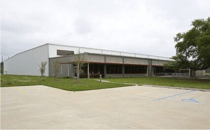

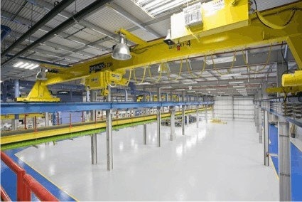
Property Detail
20157 Intralox Dr
06237703
98.69A 57.68A IN SEC 22 T6SR8E B1088 P758-765 B1148 P446 MAP 1088758-765XXXXXXXXXXXXXXXX 2.29A PARCEL 1 2.90A PARCEL 2 & 35.8
Loftbuilding
Tangipahoa
A Areas with a 1% annual chance of flooding and a 26% chance of flooding over the life of a 30-year mortgage.
Louisiana
2025
98.69 AC
2025
Louisiana South Area
954003
Other Market Areas
309,554 SF
Hammond, LA
NEARBY LISTINGS FOR SALE OR LEASE
DEMOGRAPHICS near 20157 Intralox Dr
1 mile
3 mile
5 mile
2025 Total Population
1,069
10,393
37,117
2030 Population
1,114
10,845
38,748
Pop Growth 2025-2030
+ 4.21%
+ 4.35%
+ 4.39%
Average Age
40
38
37
2025 Total Households
435
4,171
14,141
HH Growth 2025-2030
+ 4.37%
+ 4.56%
+ 4.65%
Median Household Inc
$81,818
$62,077
$56,869
Avg Household Size
2.40
2.50
2.40
2025 Avg HH Vehicles
2.00
2.00
2.00
Median Home Value
$256,666
$263,375
$236,030
Median Year Built
2003
2001
1998
Nearby Places
Map Layers
Map Styles
 Street
 Aerial
Layers
 Traffic
 Biking
Places
Listings with unknown addresses are not visible on the map
- Restaurants
- Banks
- Shops
- Fitness
- Groceries
PUBLIC TRANSPORTATION
COMMUTER RAIL
Hammond Amtrak Station (City of New Orleans - Amtrak)
Drive
Walk
Distance
Hammond Amtrak Station (City of New Orleans - Amtrak)
8 min
4.7 mi
Freight Ports
Port of New Orleans
Drive
Walk
Distance
Port of New Orleans
82 min
61.1 mi
Nearby Properties
Address
Land Use
TOTAL SIZE
Lot Size
Zoning
Address
Land Use
TOTAL SIZE
Lot Size
Zoning
124,912 SF
12.50 AC
Address
Land Use
TOTAL SIZE
Lot Size
Zoning
666,424 SF
82.56 AC
Address
Land Use
TOTAL SIZE
Lot Size
Zoning
624,811 SF
41.75 AC
Address
Land Use
TOTAL SIZE
Lot Size
Zoning
61,000 SF
11.91 AC
Address
Land Use
TOTAL SIZE
Lot Size
Zoning
52,074 SF
7.40 AC
Address
Land Use
TOTAL SIZE
Lot Size
Zoning
201,555 SF
11.17 AC
Address
Land Use
TOTAL SIZE
Lot Size
Zoning
165,402 SF
28.50 AC
Address
Land Use
TOTAL SIZE
Lot Size
Zoning
35,100 SF
3.20 AC
Address
Land Use
TOTAL SIZE
Lot Size
Zoning
353.46 AC
Address
Land Use
TOTAL SIZE
Lot Size
Zoning
100,000 SF
6.32 AC
Address
Land Use
TOTAL SIZE
Lot Size
Zoning
62,962 SF
10.36 AC
Address
Land Use
TOTAL SIZE
Lot Size
Zoning
147,500 SF
7.47 AC
Address
Land Use
TOTAL SIZE
Lot Size
Zoning
100,000 SF
5.07 AC
Address
Land Use
TOTAL SIZE
Lot Size
Zoning
23,160 SF
6.16 AC
Address
Land Use
TOTAL SIZE
Lot Size
Zoning
31,136 SF
3.30 AC
Address
Land Use
TOTAL SIZE
Lot Size
Zoning
120,000 SF
5.98 AC
Address
Land Use
TOTAL SIZE
Lot Size
Zoning
52,200 SF
14.24 AC
Address
Land Use
TOTAL SIZE
Lot Size
Zoning
13,044 SF
3 AC
Address
Land Use
TOTAL SIZE
Lot Size
Zoning
26,000 SF
2.90 AC
Address
Land Use
TOTAL SIZE
Lot Size
Zoning
86,070 SF
9.46 AC
Address
Land Use
TOTAL SIZE
Lot Size
Zoning
58,960 SF
8.88 AC
Address
Land Use
TOTAL SIZE
Lot Size
Zoning
68,000 SF
6.67 AC
Address
Land Use
TOTAL SIZE
Lot Size
Zoning
60,000 SF
11.76 AC
Address
Land Use
TOTAL SIZE
Lot Size
Zoning
38,205 SF
2.58 AC
Address
Land Use
TOTAL SIZE
Lot Size
Zoning
24,600 SF
4.02 AC
Address
Land Use
TOTAL SIZE
Lot Size
Zoning
17,490 SF
61.19 AC
Address
Land Use
TOTAL SIZE
Lot Size
Zoning
100,000 SF
5.07 AC
Address
Land Use
TOTAL SIZE
Lot Size
Zoning
30,012 SF
2.51 AC
Address
Land Use
TOTAL SIZE
Lot Size
Zoning
38,679 SF
0.72 AC
The World's #1 Commercial Real Estate Marketplace
Connect with us
© 2026 CoStar Group
The information above has been obtained from sources believed reliable. While we do not doubt its accuracy we have not verified it and make no guarantee, warranty or representation about it. It is your responsibility to independently confirm its accuracy and completeness. Any projections, opinions, assumptions, or estimates used are for example only and do not represent the current or future performance of the property. The value of this transaction to you depends on tax and other factors which should be evaluated by your tax, financial, and legal advisors. You and your advisors should conduct a careful, independent investigation of the property to determine to your satisfaction the suitability of the property for your needs.