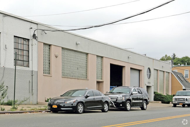
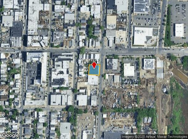
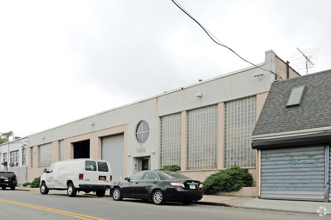
Property Record
2016 130Th St, College Point, NY 11356

NEARBY LISTINGS FOR SALE OR LEASE
Property Detail
2016 130Th St
04174-0031
Queens
Warehouse
New York
X
31
3604970114F
0.23 AC
2024
Northeast Queens
2025
Long Island (New York)
090700
New York-Jersey City-White Plains, NY-NJ
9,690 SF
DEMOGRAPHICS near 2016 130Th St
1 mile
3 mile
5 mile
2024 Total Population
39,435
450,739
1,653,296
2029 Population
36,160
417,277
1,542,351
Pop Growth 2024-2029
(8.30%)
(7.42%)
(6.71%)
Average Age
43
42
41
2024 Total Households
12,886
147,681
592,489
HH Growth 2024-2029
(8.56%)
(7.65%)
(7.00%)
Median Household Inc
$70,344
$59,932
$61,887
Avg Household Size
2.90
2.90
2.70
2024 Avg HH Vehicles
1.00
1.00
1.00
Median Home Value
$618,274
$700,773
$682,299
Median Year Built
1957
1956
1954
Nearby Places
Map Layers
Map Styles
 Street
 Aerial
Transit
 Traffic
 Biking
Places
Listings with unknown addresses are not visible on the map
- Restaurants
- Banks
- Shops
- Fitness
- Groceries
PUBLIC TRANSPORTATION
COMMUTER RAIL
Flushing-Main Street Station (Port Washington Branch - Long Island Rail Road)
Drive
Walk
Distance
Flushing-Main Street Station (Port Washington Branch - Long Island Rail Road)
8 min
2.1 mi
Murray Hill Station (Port Washington Branch - Long Island Rail Road)
Drive
Walk
Distance
Murray Hill Station (Port Washington Branch - Long Island Rail Road)
10 min
2.8 mi
AIRPORT
LaGuardia
Drive
Walk
Distance
LaGuardia
9 min
4.3 mi
John F Kennedy International
Drive
Walk
Distance
John F Kennedy International
17 min
11.6 mi
Westchester County
Drive
Walk
Distance
Westchester County
35 min
26.4 mi
Freight Ports
NY - Red Hook Container Terminal
Drive
Walk
Distance
NY - Red Hook Container Terminal
1 min
11.0 mi
SALE & LEASE HISTORY
LISTING DATE
SALE/LEASE

Oct 25, 2018
For Sale
Nearby Properties
Address
Land Use
TOTAL SIZE
Lot Size
Zoning
Address
Land Use
TOTAL SIZE
Lot Size
Zoning
5,519,372 SF
409.21 AC
C8-2
Address
Land Use
TOTAL SIZE
Lot Size
Zoning
1,258,350 SF
410.24 AC
PARK
Address
Land Use
TOTAL SIZE
Lot Size
Zoning
1,012,000 SF
7.79 AC
R6
Address
Land Use
TOTAL SIZE
Lot Size
Zoning
703,265 SF
83.45 AC
R4
Address
Land Use
TOTAL SIZE
Lot Size
Zoning
4,050 SF
113.40 AC
PARK
Address
Land Use
TOTAL SIZE
Lot Size
Zoning
480 SF
55.26 AC
R4A
Address
Land Use
TOTAL SIZE
Lot Size
Zoning
480 SF
55.26 AC
R4A
Address
Land Use
TOTAL SIZE
Lot Size
Zoning
480 SF
55.26 AC
R4A
Address
Land Use
TOTAL SIZE
Lot Size
Zoning
480 SF
55.26 AC
R4A
Address
Land Use
TOTAL SIZE
Lot Size
Zoning
480 SF
55.26 AC
R4A
Address
Land Use
TOTAL SIZE
Lot Size
Zoning
480 SF
55.26 AC
R4A
Address
Land Use
TOTAL SIZE
Lot Size
Zoning
480 SF
55.26 AC
R4A
Address
Land Use
TOTAL SIZE
Lot Size
Zoning
480 SF
55.26 AC
R4A
Address
Land Use
TOTAL SIZE
Lot Size
Zoning
480 SF
55.26 AC
R4A
Address
Land Use
TOTAL SIZE
Lot Size
Zoning
480 SF
55.26 AC
R4A
Address
Land Use
TOTAL SIZE
Lot Size
Zoning
480 SF
55.26 AC
R4A
Address
Land Use
TOTAL SIZE
Lot Size
Zoning
480 SF
55.26 AC
R4A
Address
Land Use
TOTAL SIZE
Lot Size
Zoning
480 SF
55.26 AC
R4A
Address
Land Use
TOTAL SIZE
Lot Size
Zoning
480 SF
55.26 AC
R4A
Address
Land Use
TOTAL SIZE
Lot Size
Zoning
480 SF
55.26 AC
R4A
Address
Land Use
TOTAL SIZE
Lot Size
Zoning
480 SF
55.26 AC
R4A
Address
Land Use
TOTAL SIZE
Lot Size
Zoning
480 SF
55.26 AC
R4A
Address
Land Use
TOTAL SIZE
Lot Size
Zoning
480 SF
55.26 AC
R4A
Address
Land Use
TOTAL SIZE
Lot Size
Zoning
480 SF
55.26 AC
R4A
Address
Land Use
TOTAL SIZE
Lot Size
Zoning
480 SF
55.26 AC
R4A
Address
Land Use
TOTAL SIZE
Lot Size
Zoning
480 SF
55.26 AC
R4A
Address
Land Use
TOTAL SIZE
Lot Size
Zoning
480 SF
55.26 AC
R4A
Address
Land Use
TOTAL SIZE
Lot Size
Zoning
480 SF
55.26 AC
R4A
Address
Land Use
TOTAL SIZE
Lot Size
Zoning
480 SF
55.26 AC
R4A
Address
Land Use
TOTAL SIZE
Lot Size
Zoning
480 SF
55.26 AC
R4A
The World's #1 Commercial Real Estate Marketplace
Connect with us
© 2026 CoStar Group
The information above has been obtained from sources believed reliable. While we do not doubt its accuracy we have not verified it and make no guarantee, warranty or representation about it. It is your responsibility to independently confirm its accuracy and completeness. Any projections, opinions, assumptions, or estimates used are for example only and do not represent the current or future performance of the property. The value of this transaction to you depends on tax and other factors which should be evaluated by your tax, financial, and legal advisors. You and your advisors should conduct a careful, independent investigation of the property to determine to your satisfaction the suitability of the property for your needs.