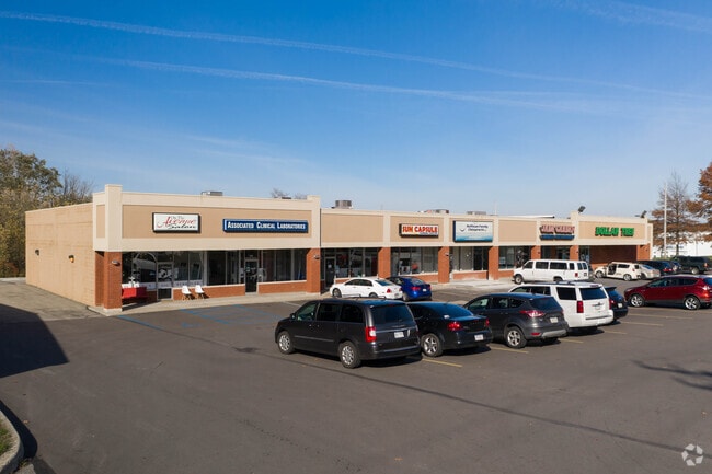
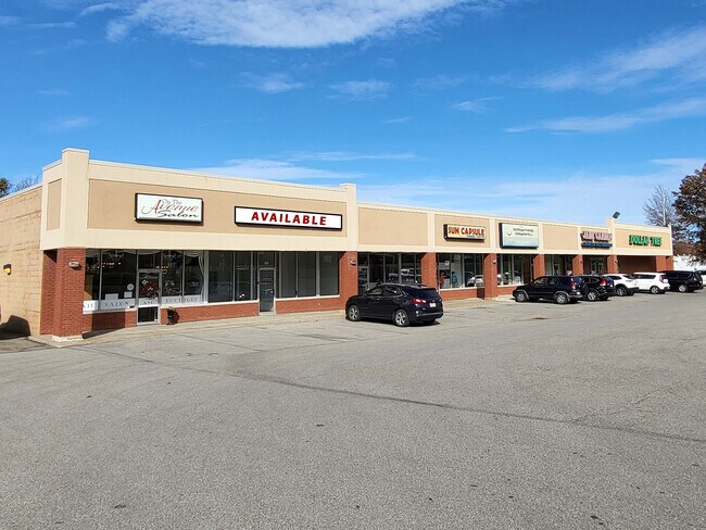
Property Record
2018 E 38Th St, Erie, PA 16510

NEARBY LISTINGS FOR SALE OR LEASE
Property Detail
2018 E 38Th St
Erie, PA
Land Lanecor Assoc 02
18-051-062.0-100.00
2018 36 E 38 ST 2.1826 AC
Stripcommercialcenter
Erie
X
Pennsylvania
42049C0207D
10000
2025
2.18 AC
2025
Greater Erie
011508
Erie
19,868 SF
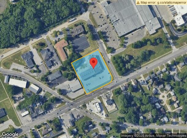
DEMOGRAPHICS near 2018 E 38Th St
1 Mile
3 Mile
5 Mile
2024 Total Population
9,970
73,565
131,643
2029 Population
9,818
72,679
130,201
Pop Growth 2024-2029
(1.52%)
(1.20%)
(1.10%)
Average Age
43
39
40
2024 Total Households
4,193
28,145
53,229
HH Growth 2024-2029
(1.67%)
(1.34%)
(1.20%)
Median Household Inc
$59,449
$45,744
$47,362
Avg Household Size
2.30
2.40
2.30
2024 Avg HH Vehicles
2.00
1.00
1.00
Median Home Value
$109,503
$105,911
$122,151
Median Year Built
1969
1955
1955
Nearby Places
Map Layers
Map Styles
 Street
 Aerial
- Restaurants
- Banks
- Shops
- Fitness
- Groceries
PUBLIC TRANSPORTATION
AIRPORT
Erie International/Tom Ridge Field
DRIVE
WALK
Distance
Erie International/Tom Ridge Field
21 min
9.8 mi
Freight Ports
Port of Baltimore
DRIVE
WALK
Distance
Port of Baltimore
1 min
266.6 mi
SALE & LEASE HISTORY
LISTING DATE
SALE/LEASE

Nov 21, 2024
For Sale
Mar 06, 2018
For Lease
Jul 25, 2019
For Lease
Feb 16, 2017
For Lease
Dec 13, 2024
For Lease
Aug 18, 2020
For Lease
Nearby Properties
Address
Land Use
TOTAL SIZE
Lot Size
Zoning
Address
Land Use
TOTAL SIZE
Lot Size
Zoning
31,764 SF
46.83 AC
R3
Address
Land Use
TOTAL SIZE
Lot Size
Zoning
227,630 SF
343.90 AC
I1
Address
Land Use
TOTAL SIZE
Lot Size
Zoning
2.73 AC
C3
Address
Land Use
TOTAL SIZE
Lot Size
Zoning
630,344 SF
7.57 AC
RLB
Address
Land Use
TOTAL SIZE
Lot Size
Zoning
5 AC
RLB
Address
Land Use
TOTAL SIZE
Lot Size
Zoning
68,626 SF
86.88 AC
B1
Address
Land Use
TOTAL SIZE
Lot Size
Zoning
170,870 SF
4.51 AC
RLB
Address
Land Use
TOTAL SIZE
Lot Size
Zoning
92,635 SF
8.45 AC
B1
Address
Land Use
TOTAL SIZE
Lot Size
Zoning
8.60 AC
R2
Address
Land Use
TOTAL SIZE
Lot Size
Zoning
23,092 SF
31.24 AC
DR
Address
Land Use
TOTAL SIZE
Lot Size
Zoning
23.31 AC
C1
Address
Land Use
TOTAL SIZE
Lot Size
Zoning
163,596 SF
14.31 AC
C2
Address
Land Use
TOTAL SIZE
Lot Size
Zoning
178,236 SF
26.15 AC
RLB
Address
Land Use
TOTAL SIZE
Lot Size
Zoning
18.55 AC
M1
Address
Land Use
TOTAL SIZE
Lot Size
Zoning
88,232 SF
1 AC
RLB
Address
Land Use
TOTAL SIZE
Lot Size
Zoning
70,092 SF
10.78 AC
DR
Address
Land Use
TOTAL SIZE
Lot Size
Zoning
59,300 SF
16.25 AC
Address
Land Use
TOTAL SIZE
Lot Size
Zoning
2,352 SF
3 AC
WR
Address
Land Use
TOTAL SIZE
Lot Size
Zoning
9.38 AC
C1
Address
Land Use
TOTAL SIZE
Lot Size
Zoning
23.95 AC
DR
Address
Land Use
TOTAL SIZE
Lot Size
Zoning
92,284 SF
3.94 AC
B3
Address
Land Use
TOTAL SIZE
Lot Size
Zoning
118,270 SF
5.64 AC
R2A
Address
Land Use
TOTAL SIZE
Lot Size
Zoning
121,197 SF
7.58 AC
Address
Land Use
TOTAL SIZE
Lot Size
Zoning
39,572 SF
6.40 AC
RLB
Address
Land Use
TOTAL SIZE
Lot Size
Zoning
62.79 AC
R2B
Address
Land Use
TOTAL SIZE
Lot Size
Zoning
268,264 SF
1.55 AC
RLB
Address
Land Use
TOTAL SIZE
Lot Size
Zoning
41,976 SF
6.50 AC
R2A
Address
Land Use
TOTAL SIZE
Lot Size
Zoning
158,708 SF
1.25 AC
C3
Address
Land Use
TOTAL SIZE
Lot Size
Zoning
170,870 SF
2.31 AC
RLB
Address
Land Use
TOTAL SIZE
Lot Size
Zoning
13,620 SF
1.21 AC
B1
The World's #1 Commercial Real Estate Marketplace
Connect with us
© 2025 CoStar Group
The information above has been obtained from sources believed reliable. While we do not doubt its accuracy we have not verified it and make no guarantee, warranty or representation about it. It is your responsibility to independently confirm its accuracy and completeness. Any projections, opinions, assumptions, or estimates used are for example only and do not represent the current or future performance of the property. The value of this transaction to you depends on tax and other factors which should be evaluated by your tax, financial, and legal advisors. You and your advisors should conduct a careful, independent investigation of the property to determine to your satisfaction the suitability of the property for your needs.