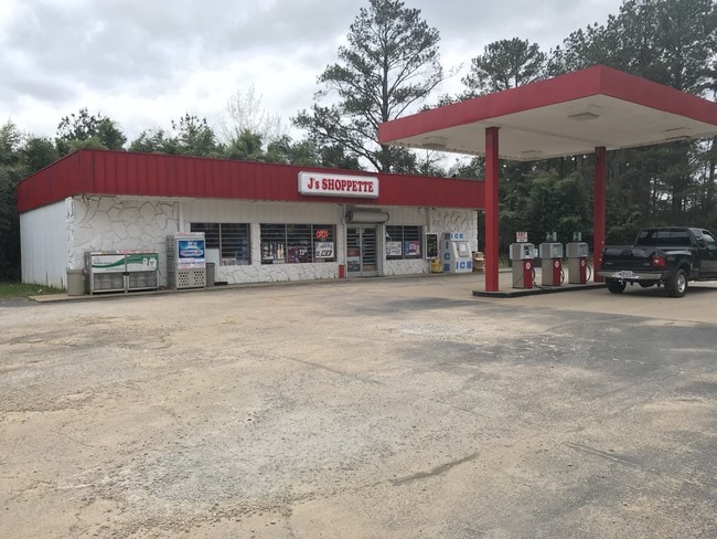
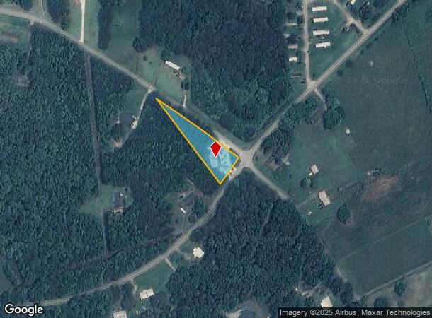
Property Record
2018 Hays Mill Rd, Carrollton, GA 30117

NEARBY LISTINGS FOR SALE OR LEASE
Property Detail
2018 Hays Mill Rd
091-0311
JS SHOP/LOT HAYS MILL RD
Storebuilding
Carroll
X
Georgia
13045C0265D
0.84 AC
2025
W Carroll County
2025
Atlanta
911102
Atlanta-Sandy Springs-Roswell, GA
1,800 SF
DEMOGRAPHICS near 2018 Hays Mill Rd
1 Mile
3 Mile
5 Mile
2024 Total Population
756
9,949
34,194
2029 Population
843
11,108
37,935
Pop Growth 2024-2029
+ 11.51%
+ 11.65%
+ 10.94%
Average Age
41
39
36
2024 Total Households
268
3,862
12,329
HH Growth 2024-2029
+ 11.94%
+ 11.86%
+ 11.23%
Median Household Inc
$93,028
$68,058
$47,697
Avg Household Size
2.70
2.50
2.50
2024 Avg HH Vehicles
2.00
2.00
2.00
Median Home Value
$260,988
$279,641
$247,214
Median Year Built
1988
1985
1985
Nearby Places
Map Layers
Map Styles
 Street
 Aerial
- Restaurants
- Banks
- Shops
- Fitness
- Groceries
SALE & LEASE HISTORY
LISTING DATE
SALE/LEASE

Mar 29, 2018
For Sale
Nearby Properties
Address
Land Use
TOTAL SIZE
Lot Size
Zoning
Address
Land Use
TOTAL SIZE
Lot Size
Zoning
261,905 SF
64.74 AC
R2
Address
Land Use
TOTAL SIZE
Lot Size
Zoning
351,903 SF
30.04 AC
C2
Address
Land Use
TOTAL SIZE
Lot Size
Zoning
32,778 SF
3.89 AC
OI
Address
Land Use
TOTAL SIZE
Lot Size
Zoning
35.33 AC
OI
Address
Land Use
TOTAL SIZE
Lot Size
Zoning
159,860 SF
20.74 AC
C2
Address
Land Use
TOTAL SIZE
Lot Size
Zoning
142,740 SF
8.13 AC
C2
Address
Land Use
TOTAL SIZE
Lot Size
Zoning
217,766 SF
28.46 AC
C2
Address
Land Use
TOTAL SIZE
Lot Size
Zoning
83,421 SF
4.28 AC
C2
Address
Land Use
TOTAL SIZE
Lot Size
Zoning
97,509 SF
15.50 AC
001
Address
Land Use
TOTAL SIZE
Lot Size
Zoning
138,903 SF
15.27 AC
C2
Address
Land Use
TOTAL SIZE
Lot Size
Zoning
109,900 SF
11.39 AC
C2
Address
Land Use
TOTAL SIZE
Lot Size
Zoning
3,240 SF
13.42 AC
C2
Address
Land Use
TOTAL SIZE
Lot Size
Zoning
119,925 SF
10.10 AC
OI/PUD
Address
Land Use
TOTAL SIZE
Lot Size
Zoning
49,314 SF
7.74 AC
001
Address
Land Use
TOTAL SIZE
Lot Size
Zoning
11,758 SF
3.91 AC
C2
Address
Land Use
TOTAL SIZE
Lot Size
Zoning
89,273 SF
7.90 AC
C2
Address
Land Use
TOTAL SIZE
Lot Size
Zoning
74,785 SF
26.08 AC
OI
Address
Land Use
TOTAL SIZE
Lot Size
Zoning
74,920 SF
8.19 AC
C2
Address
Land Use
TOTAL SIZE
Lot Size
Zoning
47,090 SF
7.78 AC
C2
Address
Land Use
TOTAL SIZE
Lot Size
Zoning
11,628 SF
2.77 AC
C2
Address
Land Use
TOTAL SIZE
Lot Size
Zoning
7,960 SF
2.83 AC
C2
Address
Land Use
TOTAL SIZE
Lot Size
Zoning
67,080 SF
4.38 AC
C2
Address
Land Use
TOTAL SIZE
Lot Size
Zoning
13,196 SF
4.85 AC
R2
Address
Land Use
TOTAL SIZE
Lot Size
Zoning
17,414 SF
8.02 AC
R3
Address
Land Use
TOTAL SIZE
Lot Size
Zoning
33,300 SF
3.34 AC
C2
Address
Land Use
TOTAL SIZE
Lot Size
Zoning
10,418 SF
2.01 AC
C2
Address
Land Use
TOTAL SIZE
Lot Size
Zoning
11,036 SF
3.08 AC
C2
Address
Land Use
TOTAL SIZE
Lot Size
Zoning
5,180 SF
3.74 AC
R2
Address
Land Use
TOTAL SIZE
Lot Size
Zoning
27,506 SF
3.90 AC
C2
Address
Land Use
TOTAL SIZE
Lot Size
Zoning
22,772 SF
9 AC
R20
The World's #1 Commercial Real Estate Marketplace
Connect with us
© 2025 CoStar Group
The information above has been obtained from sources believed reliable. While we do not doubt its accuracy we have not verified it and make no guarantee, warranty or representation about it. It is your responsibility to independently confirm its accuracy and completeness. Any projections, opinions, assumptions, or estimates used are for example only and do not represent the current or future performance of the property. The value of this transaction to you depends on tax and other factors which should be evaluated by your tax, financial, and legal advisors. You and your advisors should conduct a careful, independent investigation of the property to determine to your satisfaction the suitability of the property for your needs.