Property Record
2018 Maxwell Ave, Evansville, IN 47711


NEARBY LISTINGS FOR SALE OR LEASE
Property Detail
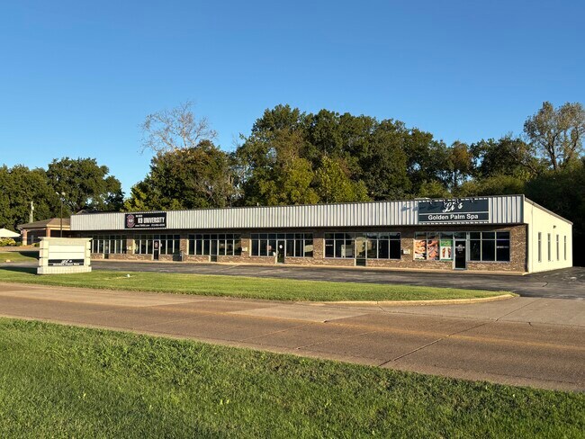
2018 Maxwell Ave
82-06-15-014-171.001-027
Replat Of Oak Hill
Stripcommercialcenter
OAK HILL COMMERCIAL MS PT 5 L1 & L2 & REPLAT OAK HILL COMMERCIAL SUB PT IV L2
AE
Vanderburgh
21101C0085E
Indiana
2024
3.34 AC
2024
Northside/Airport
010207
Evansville
9,760 SF
Evansville, IN
DEMOGRAPHICS near 2018 Maxwell Ave
1 Mile
3 Mile
5 Mile
2024 Total Population
6,226
75,005
138,836
2029 Population
6,194
75,652
139,475
Pop Growth 2024-2029
(0.51%)
+ 0.86%
+ 0.46%
Average Age
42
40
40
2024 Total Households
2,812
32,714
60,276
HH Growth 2024-2029
(0.53%)
+ 0.85%
+ 0.47%
Median Household Inc
$51,510
$47,303
$50,288
Avg Household Size
2.10
2.10
2.20
2024 Avg HH Vehicles
2.00
2.00
2.00
Median Home Value
$86,309
$111,944
$133,577
Median Year Built
1953
1958
1967
Nearby Places
Map Layers
Map Styles
 Street
 Aerial
- Restaurants
- Banks
- Shops
- Fitness
- Groceries
PUBLIC TRANSPORTATION
AIRPORT
Evansville Regional
DRIVE
WALK
Distance
Evansville Regional
9 min
3.7 mi
SALE & LEASE HISTORY
LISTING DATE
SALE/LEASE

Sep 25, 2016
For Lease
Nov 16, 2018
For Lease
Jun 10, 2021
For Lease
Feb 06, 2024
For Sale
Nearby Properties
Address
Land Use
TOTAL SIZE
Lot Size
Zoning
Address
Land Use
TOTAL SIZE
Lot Size
Zoning
451,370 SF
23.93 AC
Address
Land Use
TOTAL SIZE
Lot Size
Zoning
169,860 SF
20.33 AC
Address
Land Use
TOTAL SIZE
Lot Size
Zoning
132,150 SF
11.36 AC
Address
Land Use
TOTAL SIZE
Lot Size
Zoning
51,342 SF
4.43 AC
Address
Land Use
TOTAL SIZE
Lot Size
Zoning
38,566 SF
14.66 AC
Address
Land Use
TOTAL SIZE
Lot Size
Zoning
117,580 SF
1.74 AC
Address
Land Use
TOTAL SIZE
Lot Size
Zoning
5,005 SF
20.13 AC
Address
Land Use
TOTAL SIZE
Lot Size
Zoning
21,831 SF
3.03 AC
Address
Land Use
TOTAL SIZE
Lot Size
Zoning
4,831 SF
22.16 AC
Address
Land Use
TOTAL SIZE
Lot Size
Zoning
165,472 SF
1.38 AC
Address
Land Use
TOTAL SIZE
Lot Size
Zoning
992,266 SF
116.92 AC
Address
Land Use
TOTAL SIZE
Lot Size
Zoning
17,640 SF
12.13 AC
Address
Land Use
TOTAL SIZE
Lot Size
Zoning
5,000 SF
21.20 AC
Address
Land Use
TOTAL SIZE
Lot Size
Zoning
10,619 SF
29.18 AC
Address
Land Use
TOTAL SIZE
Lot Size
Zoning
4,165 SF
17.92 AC
Address
Land Use
TOTAL SIZE
Lot Size
Zoning
92,132 SF
1.68 AC
Address
Land Use
TOTAL SIZE
Lot Size
Zoning
223,202 SF
2.28 AC
Address
Land Use
TOTAL SIZE
Lot Size
Zoning
784,971 SF
15.37 AC
Address
Land Use
TOTAL SIZE
Lot Size
Zoning
194,564 SF
24.47 AC
Address
Land Use
TOTAL SIZE
Lot Size
Zoning
87,099 SF
2.28 AC
Address
Land Use
TOTAL SIZE
Lot Size
Zoning
103,226 SF
10.64 AC
Address
Land Use
TOTAL SIZE
Lot Size
Zoning
3,950 SF
16.77 AC
Address
Land Use
TOTAL SIZE
Lot Size
Zoning
162,726 SF
22.71 AC
Address
Land Use
TOTAL SIZE
Lot Size
Zoning
82,488 SF
1.90 AC
8
Address
Land Use
TOTAL SIZE
Lot Size
Zoning
20,286 SF
4.57 AC
Address
Land Use
TOTAL SIZE
Lot Size
Zoning
61,652 SF
15.02 AC
Address
Land Use
TOTAL SIZE
Lot Size
Zoning
15,670 SF
9.55 AC
Address
Land Use
TOTAL SIZE
Lot Size
Zoning
184,046 SF
10.05 AC
Address
Land Use
TOTAL SIZE
Lot Size
Zoning
13,364 SF
5.57 AC
Address
Land Use
TOTAL SIZE
Lot Size
Zoning
311,804 SF
31.94 AC
The World's #1 Commercial Real Estate Marketplace
Connect with us
© 2026 CoStar Group
The information above has been obtained from sources believed reliable. While we do not doubt its accuracy we have not verified it and make no guarantee, warranty or representation about it. It is your responsibility to independently confirm its accuracy and completeness. Any projections, opinions, assumptions, or estimates used are for example only and do not represent the current or future performance of the property. The value of this transaction to you depends on tax and other factors which should be evaluated by your tax, financial, and legal advisors. You and your advisors should conduct a careful, independent investigation of the property to determine to your satisfaction the suitability of the property for your needs.