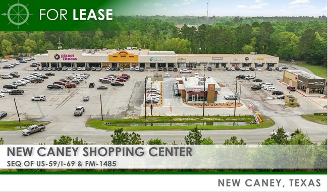
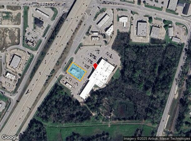
Property Record
20185 Us Highway 59, New Caney, TX 77357
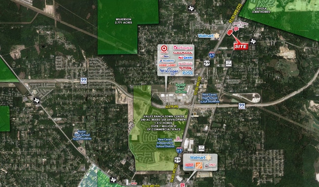
NEARBY LISTINGS FOR SALE OR LEASE
Property Detail
20185 Us Highway 59
7409-00-00100
New Caney Realty Addition Partial Replat
Commercialnec
S740901 - NEW CANEY REALTY ADDITION PARTIAL REPLAT NO 1 AND EXTENSION, RES B, ACRES 0.4924
AE
Montgomery
48339C0600G
Texas
2024
0.49 AC
2025
Montgomery County
692501
Houston
2,961 SF
Houston-The Woodlands-Sugar Land, TX
DEMOGRAPHICS near 20185 Us Highway 59
1 Mile
3 Mile
5 Mile
2024 Total Population
4,607
31,418
73,349
2029 Population
5,787
39,272
90,612
Pop Growth 2024-2029
+ 25.61%
+ 25.00%
+ 23.54%
Average Age
35
35
35
2024 Total Households
1,539
10,401
23,795
HH Growth 2024-2029
+ 25.80%
+ 25.16%
+ 23.78%
Median Household Inc
$76,515
$80,484
$75,005
Avg Household Size
2.90
3.00
3.00
2024 Avg HH Vehicles
2.00
2.00
2.00
Median Home Value
$174,557
$220,582
$230,234
Median Year Built
2008
2006
2004
Nearby Places
Map Layers
Map Styles
 Street
 Aerial
- Restaurants
- Banks
- Shops
- Fitness
- Groceries
PUBLIC TRANSPORTATION
AIRPORT
George Bush Intcntl/Houston
DRIVE
WALK
Distance
George Bush Intcntl/Houston
25 min
19.7 mi
Freight Ports
Port of Houston
DRIVE
WALK
Distance
Port of Houston
43 min
34.7 mi
SALE & LEASE HISTORY
LISTING DATE
SALE/LEASE

Sep 24, 2016
For Sale
Oct 05, 2017
For Sale
May 13, 2022
For Lease
May 10, 2022
For Sale
May 04, 2017
For Sale
Jan 23, 2024
For Lease
Feb 24, 2017
For Sale
Feb 16, 2017
For Sale
Apr 13, 2018
For Sale
Nearby Properties
Address
Land Use
TOTAL SIZE
Lot Size
Zoning
Address
Land Use
TOTAL SIZE
Lot Size
Zoning
430,982 SF
21.50 AC
Address
Land Use
TOTAL SIZE
Lot Size
Zoning
298,715 SF
16.28 AC
Address
Land Use
TOTAL SIZE
Lot Size
Zoning
444,537 SF
55.21 AC
5
Address
Land Use
TOTAL SIZE
Lot Size
Zoning
274,809 SF
11.89 AC
Address
Land Use
TOTAL SIZE
Lot Size
Zoning
29,782 SF
28.69 AC
Address
Land Use
TOTAL SIZE
Lot Size
Zoning
154,584 SF
46.76 AC
Address
Land Use
TOTAL SIZE
Lot Size
Zoning
161,302 SF
60.09 AC
5
Address
Land Use
TOTAL SIZE
Lot Size
Zoning
187,696 SF
20.07 AC
Address
Land Use
TOTAL SIZE
Lot Size
Zoning
149,963 SF
49.98 AC
Address
Land Use
TOTAL SIZE
Lot Size
Zoning
76,292 SF
32.01 AC
5
Address
Land Use
TOTAL SIZE
Lot Size
Zoning
165,381 SF
16.60 AC
Address
Land Use
TOTAL SIZE
Lot Size
Zoning
224,810 SF
21.64 AC
5
Address
Land Use
TOTAL SIZE
Lot Size
Zoning
121,871 SF
12.59 AC
Address
Land Use
TOTAL SIZE
Lot Size
Zoning
131,364 SF
4.63 AC
5
Address
Land Use
TOTAL SIZE
Lot Size
Zoning
131,028 SF
9.46 AC
Address
Land Use
TOTAL SIZE
Lot Size
Zoning
128,724 SF
29.89 AC
Address
Land Use
TOTAL SIZE
Lot Size
Zoning
110,013 SF
13.91 AC
5
Address
Land Use
TOTAL SIZE
Lot Size
Zoning
102,184 SF
20.35 AC
Address
Land Use
TOTAL SIZE
Lot Size
Zoning
72,839 SF
5.91 AC
Address
Land Use
TOTAL SIZE
Lot Size
Zoning
53,236 SF
6.80 AC
Address
Land Use
TOTAL SIZE
Lot Size
Zoning
102,279 SF
2.18 AC
Address
Land Use
TOTAL SIZE
Lot Size
Zoning
47,145 SF
4.31 AC
Address
Land Use
TOTAL SIZE
Lot Size
Zoning
103,709 SF
17.58 AC
5
Address
Land Use
TOTAL SIZE
Lot Size
Zoning
90,133 SF
11.91 AC
5
Address
Land Use
TOTAL SIZE
Lot Size
Zoning
54,372 SF
6.26 AC
Address
Land Use
TOTAL SIZE
Lot Size
Zoning
68,756 SF
2.10 AC
Address
Land Use
TOTAL SIZE
Lot Size
Zoning
61,628 SF
30.91 AC
5
Address
Land Use
TOTAL SIZE
Lot Size
Zoning
69,560 SF
16.91 AC
5
Address
Land Use
TOTAL SIZE
Lot Size
Zoning
26,036 SF
3.10 AC
Address
Land Use
TOTAL SIZE
Lot Size
Zoning
55,425 SF
4.82 AC
The World's #1 Commercial Real Estate Marketplace
Connect with us
© 2025 CoStar Group
The information above has been obtained from sources believed reliable. While we do not doubt its accuracy we have not verified it and make no guarantee, warranty or representation about it. It is your responsibility to independently confirm its accuracy and completeness. Any projections, opinions, assumptions, or estimates used are for example only and do not represent the current or future performance of the property. The value of this transaction to you depends on tax and other factors which should be evaluated by your tax, financial, and legal advisors. You and your advisors should conduct a careful, independent investigation of the property to determine to your satisfaction the suitability of the property for your needs.