Property Record
2005 E Main St, Lakeland, FL 33801
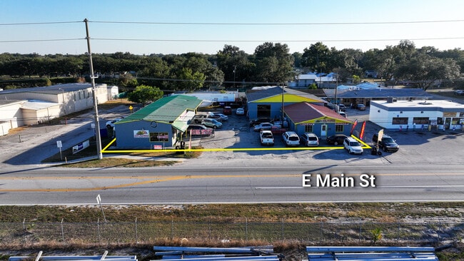
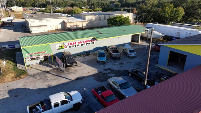
This Property Is For Sale
NEARBY LISTINGS FOR SALE OR LEASE
Property Detail
2005 E Main St
Lakeland-Winter Haven, FL
Shore Acres Gardens Replat Resubdivision
24-28-16-184600-000030
RESUB OF BLK 5 OF SHORE ACRES GARDENS REPLAT PB 38 PG 3 BLK 5 LOT 9 LESS S 40 FT
Storebuilding
Polk
X
Florida
12105C0320G
9
2024
0.29 AC
2025
Polk County
011731
Tampa/St Petersburg
1,412 SF
DEMOGRAPHICS near 2005 E Main St
1 Mile
3 Mile
5 Mile
2024 Total Population
6,781
60,413
137,975
2029 Population
8,083
71,731
164,720
Pop Growth 2024-2029
+ 19.20%
+ 18.73%
+ 19.38%
Average Age
35
38
40
2024 Total Households
2,236
22,375
54,924
HH Growth 2024-2029
+ 19.14%
+ 19.37%
+ 19.68%
Median Household Inc
$42,165
$43,245
$48,740
Avg Household Size
2.50
2.30
2.30
2024 Avg HH Vehicles
2.00
2.00
2.00
Median Home Value
$120,672
$159,018
$157,322
Median Year Built
1973
1971
1979
Nearby Places
Map Layers
Map Styles
 Street
 Aerial
- Restaurants
- Banks
- Shops
- Fitness
- Groceries
PUBLIC TRANSPORTATION
COMMUTER RAIL
Lakeland (Silver Star - Amtrak)
DRIVE
WALK
Distance
Lakeland (Silver Star - Amtrak)
3 min
1.9 mi
Freight Ports
Port of Tampa Bay
DRIVE
WALK
Distance
Port of Tampa Bay
50 min
36.5 mi
Nearby Properties
Address
Land Use
TOTAL SIZE
Lot Size
Zoning
Address
Land Use
TOTAL SIZE
Lot Size
Zoning
2,325,080 SF
27.05 AC
PUD
Address
Land Use
TOTAL SIZE
Lot Size
Zoning
414,112 SF
13.60 AC
MF22
Address
Land Use
TOTAL SIZE
Lot Size
Zoning
333,455 SF
11.90 AC
Address
Land Use
TOTAL SIZE
Lot Size
Zoning
263,185 SF
32.20 AC
C6
Address
Land Use
TOTAL SIZE
Lot Size
Zoning
417,661 SF
39.48 AC
Address
Land Use
TOTAL SIZE
Lot Size
Zoning
718,026 SF
49.37 AC
RE2
Address
Land Use
TOTAL SIZE
Lot Size
Zoning
24,871 SF
54.24 AC
RB1
Address
Land Use
TOTAL SIZE
Lot Size
Zoning
295,706 SF
1.19 AC
Address
Land Use
TOTAL SIZE
Lot Size
Zoning
394,631 SF
32.27 AC
XX
Address
Land Use
TOTAL SIZE
Lot Size
Zoning
282,596 SF
27.51 AC
RA3
Address
Land Use
TOTAL SIZE
Lot Size
Zoning
84,824 SF
163.73 AC
I2
Address
Land Use
TOTAL SIZE
Lot Size
Zoning
258,946 SF
11.73 AC
O3
Address
Land Use
TOTAL SIZE
Lot Size
Zoning
165,743 SF
17.11 AC
PUD
Address
Land Use
TOTAL SIZE
Lot Size
Zoning
155,735 SF
24.24 AC
XX
Address
Land Use
TOTAL SIZE
Lot Size
Zoning
342,987 SF
16.81 AC
Address
Land Use
TOTAL SIZE
Lot Size
Zoning
103,446 SF
2.12 AC
RB1
Address
Land Use
TOTAL SIZE
Lot Size
Zoning
135,189 SF
2.57 AC
RB1
Address
Land Use
TOTAL SIZE
Lot Size
Zoning
96,412 SF
11.03 AC
I1
Address
Land Use
TOTAL SIZE
Lot Size
Zoning
180,802 SF
76.35 AC
Address
Land Use
TOTAL SIZE
Lot Size
Zoning
286,120 SF
2.49 AC
C6
Address
Land Use
TOTAL SIZE
Lot Size
Zoning
175,230 SF
7.23 AC
MF22
Address
Land Use
TOTAL SIZE
Lot Size
Zoning
87,975 SF
5.45 AC
O1
Address
Land Use
TOTAL SIZE
Lot Size
Zoning
109,883 SF
12.40 AC
C4
Address
Land Use
TOTAL SIZE
Lot Size
Zoning
171,629 SF
14.91 AC
RA4
Address
Land Use
TOTAL SIZE
Lot Size
Zoning
130,375 SF
14.51 AC
Address
Land Use
TOTAL SIZE
Lot Size
Zoning
218,911 SF
39.21 AC
Address
Land Use
TOTAL SIZE
Lot Size
Zoning
119,141 SF
15.04 AC
RA4
Address
Land Use
TOTAL SIZE
Lot Size
Zoning
316,800 SF
9.47 AC
Address
Land Use
TOTAL SIZE
Lot Size
Zoning
206,796 SF
14.28 AC
I1
Address
Land Use
TOTAL SIZE
Lot Size
Zoning
152,129 SF
19.35 AC
MF12
The World's #1 Commercial Real Estate Marketplace
Connect with us
© 2025 CoStar Group
The information above has been obtained from sources believed reliable. While we do not doubt its accuracy we have not verified it and make no guarantee, warranty or representation about it. It is your responsibility to independently confirm its accuracy and completeness. Any projections, opinions, assumptions, or estimates used are for example only and do not represent the current or future performance of the property. The value of this transaction to you depends on tax and other factors which should be evaluated by your tax, financial, and legal advisors. You and your advisors should conduct a careful, independent investigation of the property to determine to your satisfaction the suitability of the property for your needs.