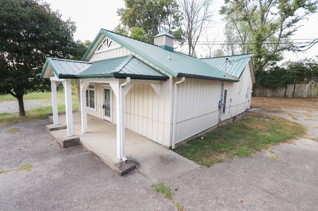
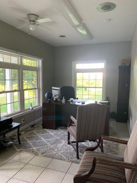
Property Record
2019 Catalpa Loop, Richmond, KY 40475

Property Detail
2019 Catalpa Loop
Richmond-Berea, KY
TRACT 1 (0.32 ACRES)
0068-0000-0027
Madison
Professionalbldglegalinsurancerealestateetc
Kentucky
AE The base floodplain where base flood elevations are provided. AE Zones are now used on new format FIRMs instead of A1-A30 Zones.
1
2025
0.32 AC
2025
Georgetown/Richmond Area
010902
Other Market Areas
2,280 SF
NEARBY LISTINGS FOR SALE OR LEASE
-
-
View all Richmond listings for sale on LoopNet.com
DEMOGRAPHICS near 2019 Catalpa Loop
1 mile
3 mile
5 mile
2025 Total Population
5,134
29,735
48,444
2030 Population
5,511
31,572
51,412
Pop Growth 2025-2030
+ 7.34%
+ 6.18%
+ 6.13%
Average Age
36
35
36
2025 Total Households
2,225
12,000
19,807
HH Growth 2025-2030
+ 7.37%
+ 6.63%
+ 6.53%
Median Household Inc
$51,201
$53,700
$59,822
Avg Household Size
2.20
2.20
2.20
2025 Avg HH Vehicles
2.00
2.00
2.00
Median Home Value
$256,078
$232,700
$247,423
Median Year Built
2000
1994
1993
Nearby Places
Map Layers
Map Styles
 Street
 Aerial
Transit
 Traffic
 Biking
Places
Listings with unknown addresses are not visible on the map
- Restaurants
- Banks
- Shops
- Fitness
- Groceries
PUBLIC TRANSPORTATION
AIRPORT
Blue Grass
Drive
Walk
Distance
Blue Grass
50 min
35.5 mi
Freight Ports
Port of Toledo
Drive
Walk
Distance
Port of Toledo
359 min
313.1 mi
SALE & LEASE HISTORY
LISTING DATE
SALE/LEASE

Sep 23, 2016
For Sale
Sep 18, 2019
For Sale
Oct 22, 2021
For Sale
Mar 20, 2018
For Sale
Jul 30, 2018
For Sale
Nearby Properties
Address
Land Use
TOTAL SIZE
Lot Size
Zoning
Address
Land Use
TOTAL SIZE
Lot Size
Zoning
13.91 AC
Address
Land Use
TOTAL SIZE
Lot Size
Zoning
Address
Land Use
TOTAL SIZE
Lot Size
Zoning
21.81 AC
Address
Land Use
TOTAL SIZE
Lot Size
Zoning
20.87 AC
Address
Land Use
TOTAL SIZE
Lot Size
Zoning
195,345 SF
23.98 AC
Address
Land Use
TOTAL SIZE
Lot Size
Zoning
105,686 SF
10.34 AC
Address
Land Use
TOTAL SIZE
Lot Size
Zoning
5,776 SF
3.33 AC
Address
Land Use
TOTAL SIZE
Lot Size
Zoning
11.05 AC
Address
Land Use
TOTAL SIZE
Lot Size
Zoning
8,520 SF
12.37 AC
Address
Land Use
TOTAL SIZE
Lot Size
Zoning
10,316 SF
5.87 AC
Address
Land Use
TOTAL SIZE
Lot Size
Zoning
10.84 AC
Address
Land Use
TOTAL SIZE
Lot Size
Zoning
Address
Land Use
TOTAL SIZE
Lot Size
Zoning
121,085 SF
16.13 AC
Address
Land Use
TOTAL SIZE
Lot Size
Zoning
97,536 SF
8.62 AC
Address
Land Use
TOTAL SIZE
Lot Size
Zoning
28.07 AC
Address
Land Use
TOTAL SIZE
Lot Size
Zoning
Address
Land Use
TOTAL SIZE
Lot Size
Zoning
228,982 SF
35.09 AC
Address
Land Use
TOTAL SIZE
Lot Size
Zoning
12,768 SF
5.28 AC
Address
Land Use
TOTAL SIZE
Lot Size
Zoning
3,540 SF
5.05 AC
Address
Land Use
TOTAL SIZE
Lot Size
Zoning
2.17 AC
Address
Land Use
TOTAL SIZE
Lot Size
Zoning
3.90 AC
Address
Land Use
TOTAL SIZE
Lot Size
Zoning
73.57 AC
Address
Land Use
TOTAL SIZE
Lot Size
Zoning
10,658 SF
1.65 AC
Address
Land Use
TOTAL SIZE
Lot Size
Zoning
1.56 AC
Address
Land Use
TOTAL SIZE
Lot Size
Zoning
2.82 AC
Address
Land Use
TOTAL SIZE
Lot Size
Zoning
2.33 AC
Address
Land Use
TOTAL SIZE
Lot Size
Zoning
1.83 AC
Address
Land Use
TOTAL SIZE
Lot Size
Zoning
2.64 AC
Address
Land Use
TOTAL SIZE
Lot Size
Zoning
60,703 SF
8.12 AC
Address
Land Use
TOTAL SIZE
Lot Size
Zoning
1.72 AC
The World's #1 Commercial Real Estate Marketplace
Connect with us
© 2026 CoStar Group
The information above has been obtained from sources believed reliable. While we do not doubt its accuracy we have not verified it and make no guarantee, warranty or representation about it. It is your responsibility to independently confirm its accuracy and completeness. Any projections, opinions, assumptions, or estimates used are for example only and do not represent the current or future performance of the property. The value of this transaction to you depends on tax and other factors which should be evaluated by your tax, financial, and legal advisors. You and your advisors should conduct a careful, independent investigation of the property to determine to your satisfaction the suitability of the property for your needs.