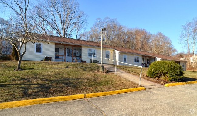
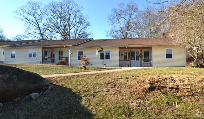
Property Record
201A Elm St, Groton, CT 06340

Property Detail
201A Elm St
Apartmenthouse5plusunits
NEW LONDON
R-40
Connecticut
B and X Area of moderate flood hazard, usually the area between the limits of the 100-year and 500-year floods.
1
2025
New London
2025
Hartford
702900
Norwich-New London-Willimantic, CT
22,500 SF
GROT-002608-001573-002661-000001
NEARBY LISTINGS FOR SALE OR LEASE
DEMOGRAPHICS near 201A Elm St
1 mile
3 mile
5 mile
2025 Total Population
2,193
16,110
43,441
2030 Population
2,234
16,542
44,281
Pop Growth 2025-2030
+ 1.87%
+ 2.68%
+ 1.93%
Average Age
51
48
44
2025 Total Households
1,011
7,296
19,489
HH Growth 2025-2030
+ 1.78%
+ 2.85%
+ 2.01%
Median Household Inc
$122,030
$109,241
$89,886
Avg Household Size
2.10
2.10
2.10
2025 Avg HH Vehicles
2.00
2.00
2.00
Median Home Value
$590,194
$501,654
$394,628
Median Year Built
1966
1968
1971
Nearby Places
Map Layers
Map Styles
 Street
 Aerial
Layers
 Traffic
 Biking
Places
Listings with unknown addresses are not visible on the map
- Restaurants
- Banks
- Shops
- Fitness
- Groceries
PUBLIC TRANSPORTATION
COMMUTER RAIL
Mystic Amtrak (Northeast Regional - Amtrak)
Drive
Walk
Distance
Mystic Amtrak (Northeast Regional - Amtrak)
6 min
2.8 mi
New London (Shore Line East - Shore Line East)
Drive
Walk
Distance
New London (Shore Line East - Shore Line East)
17 min
9.3 mi
Freight Ports
Port of Davisville, RI
Drive
Walk
Distance
Port of Davisville, RI
65 min
47.6 mi
Nearby Properties
Address
Land Use
TOTAL SIZE
Lot Size
Zoning
Address
Land Use
TOTAL SIZE
Lot Size
Zoning
10,521 SF
441.93 AC
IG
Address
Land Use
TOTAL SIZE
Lot Size
Zoning
404.81 AC
GC
Address
Land Use
TOTAL SIZE
Lot Size
Zoning
276.72 AC
GC
Address
Land Use
TOTAL SIZE
Lot Size
Zoning
8,820 SF
66.22 AC
R-12
Address
Land Use
TOTAL SIZE
Lot Size
Zoning
268,573 SF
74.66 AC
RS-20
Address
Land Use
TOTAL SIZE
Lot Size
Zoning
162,521 SF
44.19 AC
RS-20
Address
Land Use
TOTAL SIZE
Lot Size
Zoning
74,433 SF
47.37 AC
RS-20
Address
Land Use
TOTAL SIZE
Lot Size
Zoning
231,514 SF
9.33 AC
IM
Address
Land Use
TOTAL SIZE
Lot Size
Zoning
133,106 SF
17.25 AC
MTC
Address
Land Use
TOTAL SIZE
Lot Size
Zoning
33,404 SF
10.15 AC
MVC
Address
Land Use
TOTAL SIZE
Lot Size
Zoning
125,755 SF
14.63 AC
MVC
Address
Land Use
TOTAL SIZE
Lot Size
Zoning
520 SF
36.40 AC
RS-20
Address
Land Use
TOTAL SIZE
Lot Size
Zoning
37,434 SF
10.75 AC
MVC
Address
Land Use
TOTAL SIZE
Lot Size
Zoning
87,440 SF
9.30 AC
MTC
Address
Land Use
TOTAL SIZE
Lot Size
Zoning
59,024 SF
3.24 AC
RS-12
Address
Land Use
TOTAL SIZE
Lot Size
Zoning
19,274 SF
1.36 AC
GB-130
Address
Land Use
TOTAL SIZE
Lot Size
Zoning
39,386 SF
28.74 AC
RS-20
Address
Land Use
TOTAL SIZE
Lot Size
Zoning
1,880 SF
166.33 AC
IM
Address
Land Use
TOTAL SIZE
Lot Size
Zoning
10,056 SF
28.70 AC
R-12
Address
Land Use
TOTAL SIZE
Lot Size
Zoning
26,732 SF
12.44 AC
IM
Address
Land Use
TOTAL SIZE
Lot Size
Zoning
25.88 AC
RR-80
Address
Land Use
TOTAL SIZE
Lot Size
Zoning
46,652 SF
12.23 AC
RC-120
Address
Land Use
TOTAL SIZE
Lot Size
Zoning
0.77 AC
DB-5
Address
Land Use
TOTAL SIZE
Lot Size
Zoning
35,520 SF
1.61 AC
MDD
Address
Land Use
TOTAL SIZE
Lot Size
Zoning
39,667 SF
8.41 AC
RS-20
Address
Land Use
TOTAL SIZE
Lot Size
Zoning
62,549 SF
6.41 AC
IM
Address
Land Use
TOTAL SIZE
Lot Size
Zoning
5,200 SF
7.12 AC
R-20
Address
Land Use
TOTAL SIZE
Lot Size
Zoning
3,072 SF
4.79 AC
WC
Address
Land Use
TOTAL SIZE
Lot Size
Zoning
20,992 SF
5.93 AC
RS-20
Address
Land Use
TOTAL SIZE
Lot Size
Zoning
11,858 SF
GB-130
The World's #1 Commercial Real Estate Marketplace
Connect with us
© 2026 CoStar Group
The information above has been obtained from sources believed reliable. While we do not doubt its accuracy we have not verified it and make no guarantee, warranty or representation about it. It is your responsibility to independently confirm its accuracy and completeness. Any projections, opinions, assumptions, or estimates used are for example only and do not represent the current or future performance of the property. The value of this transaction to you depends on tax and other factors which should be evaluated by your tax, financial, and legal advisors. You and your advisors should conduct a careful, independent investigation of the property to determine to your satisfaction the suitability of the property for your needs.