Property Record
132 Montvu Dr, Omak, WA 98841
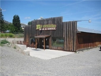
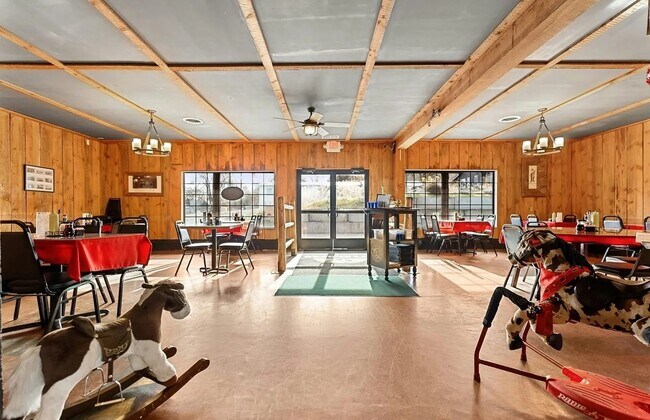
Property Detail
132 Montvu Dr
Other Market Areas
LOT 16 THRU 19 BLK 8 RIVERSIDE MH- 2716
2350081600
OKANOGAN
Multifamilydwelling
Washington
2026
16-19
2026
0.32 AC
970602
Washington State Area
NEARBY LISTINGS FOR SALE OR LEASE
-
-
View all Omak listings for sale on LoopNet.com
DEMOGRAPHICS near 132 Montvu Dr
1 mile
3 mile
5 mile
2025 Total Population
407
915
2,327
2030 Population
437
982
2,484
Pop Growth 2025-2030
+ 7.37%
+ 7.32%
+ 6.75%
Average Age
45
44
44
2025 Total Households
170
383
942
HH Growth 2025-2030
+ 7.65%
+ 7.31%
+ 6.79%
Median Household Inc
$67,250
$67,272
$66,151
Avg Household Size
2.40
2.40
2.40
2025 Avg HH Vehicles
3.00
3.00
3.00
Median Home Value
$337,878
$337,333
$352,659
Median Year Built
1989
1989
1989
Nearby Places
Map Layers
Map Styles
 Street
 Aerial
Layers
 Traffic
 Biking
Places
Listings with unknown addresses are not visible on the map
- Restaurants
- Banks
- Shops
- Fitness
- Groceries
SALE & LEASE HISTORY
LISTING DATE
SALE/LEASE

May 08, 2018
For Sale
Mar 13, 2019
For Sale
Nearby Properties
Address
Land Use
TOTAL SIZE
Lot Size
Zoning
Address
Land Use
TOTAL SIZE
Lot Size
Zoning
188,574 SF
5 AC
Address
Land Use
TOTAL SIZE
Lot Size
Zoning
17.07 AC
Address
Land Use
TOTAL SIZE
Lot Size
Zoning
30,214 SF
5.68 AC
Address
Land Use
TOTAL SIZE
Lot Size
Zoning
100,248 SF
9.09 AC
Address
Land Use
TOTAL SIZE
Lot Size
Zoning
102,489 SF
11.20 AC
Address
Land Use
TOTAL SIZE
Lot Size
Zoning
11.17 AC
Address
Land Use
TOTAL SIZE
Lot Size
Zoning
32,363 SF
2.94 AC
Address
Land Use
TOTAL SIZE
Lot Size
Zoning
49,774 SF
1.95 AC
Address
Land Use
TOTAL SIZE
Lot Size
Zoning
35,754 SF
5 AC
Address
Land Use
TOTAL SIZE
Lot Size
Zoning
32,281 SF
51.60 AC
Address
Land Use
TOTAL SIZE
Lot Size
Zoning
5,460 SF
3.47 AC
Address
Land Use
TOTAL SIZE
Lot Size
Zoning
79,056 SF
13.57 AC
Address
Land Use
TOTAL SIZE
Lot Size
Zoning
33,888 SF
2.50 AC
Address
Land Use
TOTAL SIZE
Lot Size
Zoning
16.29 AC
Address
Land Use
TOTAL SIZE
Lot Size
Zoning
35,276 SF
1.28 AC
Address
Land Use
TOTAL SIZE
Lot Size
Zoning
10,362 SF
1.49 AC
Address
Land Use
TOTAL SIZE
Lot Size
Zoning
19,864 SF
4.08 AC
Address
Land Use
TOTAL SIZE
Lot Size
Zoning
28,496 SF
0.81 AC
Address
Land Use
TOTAL SIZE
Lot Size
Zoning
4.15 AC
Address
Land Use
TOTAL SIZE
Lot Size
Zoning
77,906 SF
3.47 AC
Address
Land Use
TOTAL SIZE
Lot Size
Zoning
25,328 SF
2.20 AC
Address
Land Use
TOTAL SIZE
Lot Size
Zoning
35,891 SF
Address
Land Use
TOTAL SIZE
Lot Size
Zoning
2,800 SF
0.66 AC
Address
Land Use
TOTAL SIZE
Lot Size
Zoning
9,756 SF
0.70 AC
Address
Land Use
TOTAL SIZE
Lot Size
Zoning
19,440 SF
2.09 AC
Address
Land Use
TOTAL SIZE
Lot Size
Zoning
18,797 SF
2.97 AC
Address
Land Use
TOTAL SIZE
Lot Size
Zoning
1,472 SF
0.33 AC
Address
Land Use
TOTAL SIZE
Lot Size
Zoning
23,912 SF
16.62 AC
Address
Land Use
TOTAL SIZE
Lot Size
Zoning
9,314 SF
1.59 AC
The World's #1 Commercial Real Estate Marketplace
Connect with us
© 2026 CoStar Group
The information above has been obtained from sources believed reliable. While we do not doubt its accuracy we have not verified it and make no guarantee, warranty or representation about it. It is your responsibility to independently confirm its accuracy and completeness. Any projections, opinions, assumptions, or estimates used are for example only and do not represent the current or future performance of the property. The value of this transaction to you depends on tax and other factors which should be evaluated by your tax, financial, and legal advisors. You and your advisors should conduct a careful, independent investigation of the property to determine to your satisfaction the suitability of the property for your needs.