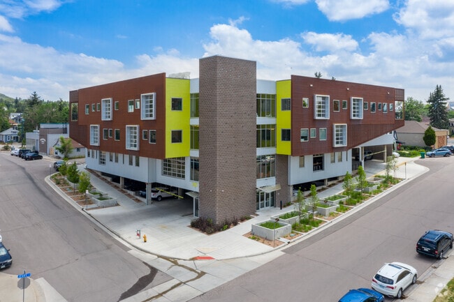
Property Record
202 6Th St, Castle Rock, CO 80104


Current Lease Availabilities
Property Detail
202 6Th St
Denver-Aurora-Centennial, CO
LOT 10A BLK 8 TOWN OF CASTLE ROCK PER LLAC 2015017969 0.48 AM/L
2505-112-05-002
Douglas
Commercialnec
Colorado
B and X Area of moderate flood hazard, usually the area between the limits of the 100-year and 500-year floods.
10a
2024
0.48 AC
2026
Parker/Castle Rock
014504
Denver
72,799 SF
NEARBY LISTINGS FOR SALE OR LEASE
DEMOGRAPHICS near 202 6Th St
1 mile
3 mile
5 mile
2025 Total Population
7,449
54,553
89,260
2030 Population
7,995
58,912
96,919
Pop Growth 2025-2030
+ 7.33%
+ 7.99%
+ 8.58%
Average Age
40
39
39
2025 Total Households
3,034
19,524
31,162
HH Growth 2025-2030
+ 7.55%
+ 8.20%
+ 8.78%
Median Household Inc
$86,312
$132,529
$143,067
Avg Household Size
2.40
2.70
2.80
2025 Avg HH Vehicles
2.00
2.00
2.00
Median Home Value
$551,374
$701,975
$739,074
Median Year Built
1987
2005
2006
Nearby Places
Map Layers
Map Styles
 Street
 Aerial
Layers
 Traffic
 Biking
Places
Listings with unknown addresses are not visible on the map
- Restaurants
- Banks
- Shops
- Fitness
- Groceries
PUBLIC TRANSPORTATION
AIRPORT
Denver International
Drive
Walk
Distance
Denver International
50 min
45.7 mi
Nearby Properties
Address
Land Use
TOTAL SIZE
Lot Size
Zoning
Address
Land Use
TOTAL SIZE
Lot Size
Zoning
836,412 SF
29.20 AC
Address
Land Use
TOTAL SIZE
Lot Size
Zoning
297,865 SF
39.95 AC
Address
Land Use
TOTAL SIZE
Lot Size
Zoning
463,911 SF
55.80 AC
Address
Land Use
TOTAL SIZE
Lot Size
Zoning
467,796 SF
55.80 AC
Address
Land Use
TOTAL SIZE
Lot Size
Zoning
117,447 SF
9.99 AC
Address
Land Use
TOTAL SIZE
Lot Size
Zoning
128,680 SF
21.86 AC
Address
Land Use
TOTAL SIZE
Lot Size
Zoning
464,037 SF
18.90 AC
Address
Land Use
TOTAL SIZE
Lot Size
Zoning
120,575 SF
30.87 AC
Address
Land Use
TOTAL SIZE
Lot Size
Zoning
150,896 SF
1.38 AC
Address
Land Use
TOTAL SIZE
Lot Size
Zoning
62,718 SF
3.47 AC
Address
Land Use
TOTAL SIZE
Lot Size
Zoning
407,977 SF
15.04 AC
Address
Land Use
TOTAL SIZE
Lot Size
Zoning
122,581 SF
13.81 AC
Address
Land Use
TOTAL SIZE
Lot Size
Zoning
227,703 SF
48.20 AC
A1
Address
Land Use
TOTAL SIZE
Lot Size
Zoning
178,877 SF
1.34 AC
Address
Land Use
TOTAL SIZE
Lot Size
Zoning
200,585 SF
2.08 AC
Address
Land Use
TOTAL SIZE
Lot Size
Zoning
105,496 SF
10.22 AC
Address
Land Use
TOTAL SIZE
Lot Size
Zoning
73,146 SF
10.25 AC
Address
Land Use
TOTAL SIZE
Lot Size
Zoning
255,509 SF
11.34 AC
Address
Land Use
TOTAL SIZE
Lot Size
Zoning
250,910 SF
12.06 AC
Address
Land Use
TOTAL SIZE
Lot Size
Zoning
256,820 SF
11.02 AC
A1
Address
Land Use
TOTAL SIZE
Lot Size
Zoning
59,843 SF
39.95 AC
Address
Land Use
TOTAL SIZE
Lot Size
Zoning
47,354 SF
14.93 AC
Address
Land Use
TOTAL SIZE
Lot Size
Zoning
74,586 SF
13.90 AC
Address
Land Use
TOTAL SIZE
Lot Size
Zoning
115,466 SF
1.05 AC
Address
Land Use
TOTAL SIZE
Lot Size
Zoning
67,426 SF
7.16 AC
Address
Land Use
TOTAL SIZE
Lot Size
Zoning
115,324 SF
7.44 AC
Address
Land Use
TOTAL SIZE
Lot Size
Zoning
65,489 SF
223.07 AC
A1
Address
Land Use
TOTAL SIZE
Lot Size
Zoning
35,863 SF
15.97 AC
Address
Land Use
TOTAL SIZE
Lot Size
Zoning
98,750 SF
5.42 AC
Address
Land Use
TOTAL SIZE
Lot Size
Zoning
50,150 SF
10.19 AC
The World's #1 Commercial Real Estate Marketplace
Connect with us
© 2026 CoStar Group
The information above has been obtained from sources believed reliable. While we do not doubt its accuracy we have not verified it and make no guarantee, warranty or representation about it. It is your responsibility to independently confirm its accuracy and completeness. Any projections, opinions, assumptions, or estimates used are for example only and do not represent the current or future performance of the property. The value of this transaction to you depends on tax and other factors which should be evaluated by your tax, financial, and legal advisors. You and your advisors should conduct a careful, independent investigation of the property to determine to your satisfaction the suitability of the property for your needs.