Property Record
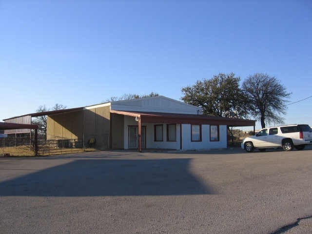
202 Banks Dr, Weatherford, TX 76087


Property Detail
202 Banks Dr
Dallas-Fort Worth-Arlington, TX
ACRES: 0.590 LOT: PT 18 (AKA 18R-A) BLK: 1 SUBD: I-20 INDUSTRIAL PARK
R000013208
Parker
Commercialnec
Texas
B and X Area of moderate flood hazard, usually the area between the limits of the 100-year and 500-year floods.
18
2024
0.59 AC
2025
Parker County
140710
Dallas/Ft Worth
4,104 SF
NEARBY LISTINGS FOR SALE OR LEASE
DEMOGRAPHICS near 202 Banks Dr
1 mile
3 mile
5 mile
2024 Total Population
2,598
24,134
54,299
2029 Population
3,021
28,144
63,253
Pop Growth 2024-2029
+ 16.28%
+ 16.62%
+ 16.49%
Average Age
39
40
40
2024 Total Households
943
9,270
20,548
HH Growth 2024-2029
+ 15.48%
+ 16.03%
+ 15.81%
Median Household Inc
$99,159
$67,088
$79,928
Avg Household Size
2.70
2.50
2.50
2024 Avg HH Vehicles
2.00
2.00
2.00
Median Home Value
$349,324
$332,337
$347,372
Median Year Built
2002
2002
1999
Nearby Places
Map Layers
Map Styles
 Street
 Aerial
Transit
 Traffic
 Biking
Places
Listings with unknown addresses are not visible on the map
- Restaurants
- Banks
- Shops
- Fitness
- Groceries
Nearby Properties
Address
Land Use
TOTAL SIZE
Lot Size
Zoning
Address
Land Use
TOTAL SIZE
Lot Size
Zoning
341,996 SF
16.60 AC
Address
Land Use
TOTAL SIZE
Lot Size
Zoning
435,251 SF
17.27 AC
Address
Land Use
TOTAL SIZE
Lot Size
Zoning
399,466 SF
11.50 AC
Address
Land Use
TOTAL SIZE
Lot Size
Zoning
279,600 SF
14.43 AC
Address
Land Use
TOTAL SIZE
Lot Size
Zoning
15.65 AC
Address
Land Use
TOTAL SIZE
Lot Size
Zoning
141,292 SF
13.88 AC
Address
Land Use
TOTAL SIZE
Lot Size
Zoning
167,850 SF
13.50 AC
Address
Land Use
TOTAL SIZE
Lot Size
Zoning
171,147 SF
8.77 AC
Address
Land Use
TOTAL SIZE
Lot Size
Zoning
Address
Land Use
TOTAL SIZE
Lot Size
Zoning
18.62 AC
Address
Land Use
TOTAL SIZE
Lot Size
Zoning
191,011 SF
24.27 AC
Address
Land Use
TOTAL SIZE
Lot Size
Zoning
103,600 SF
6 AC
Address
Land Use
TOTAL SIZE
Lot Size
Zoning
75,854 SF
8.84 AC
Address
Land Use
TOTAL SIZE
Lot Size
Zoning
255,314 SF
14.27 AC
Address
Land Use
TOTAL SIZE
Lot Size
Zoning
110,206 SF
11.02 AC
Address
Land Use
TOTAL SIZE
Lot Size
Zoning
16,624 SF
9.53 AC
Address
Land Use
TOTAL SIZE
Lot Size
Zoning
31.61 AC
Address
Land Use
TOTAL SIZE
Lot Size
Zoning
105,344 SF
17.59 AC
Address
Land Use
TOTAL SIZE
Lot Size
Zoning
210,698 SF
26.61 AC
Address
Land Use
TOTAL SIZE
Lot Size
Zoning
6.95 AC
Address
Land Use
TOTAL SIZE
Lot Size
Zoning
47,038 SF
14.84 AC
Address
Land Use
TOTAL SIZE
Lot Size
Zoning
75,968 SF
6.82 AC
Address
Land Use
TOTAL SIZE
Lot Size
Zoning
14,070 SF
6.64 AC
Address
Land Use
TOTAL SIZE
Lot Size
Zoning
104,188 SF
12.73 AC
Address
Land Use
TOTAL SIZE
Lot Size
Zoning
81,112 SF
7.34 AC
Address
Land Use
TOTAL SIZE
Lot Size
Zoning
23,886 SF
23.19 AC
Address
Land Use
TOTAL SIZE
Lot Size
Zoning
27,669 SF
3.58 AC
Address
Land Use
TOTAL SIZE
Lot Size
Zoning
134,934 SF
13.23 AC
Address
Land Use
TOTAL SIZE
Lot Size
Zoning
50,112 SF
2.97 AC
Address
Land Use
TOTAL SIZE
Lot Size
Zoning
49,054 SF
2.76 AC
The World's #1 Commercial Real Estate Marketplace
Connect with us
© 2026 CoStar Group
The information above has been obtained from sources believed reliable. While we do not doubt its accuracy we have not verified it and make no guarantee, warranty or representation about it. It is your responsibility to independently confirm its accuracy and completeness. Any projections, opinions, assumptions, or estimates used are for example only and do not represent the current or future performance of the property. The value of this transaction to you depends on tax and other factors which should be evaluated by your tax, financial, and legal advisors. You and your advisors should conduct a careful, independent investigation of the property to determine to your satisfaction the suitability of the property for your needs.