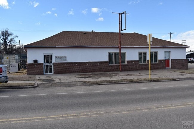
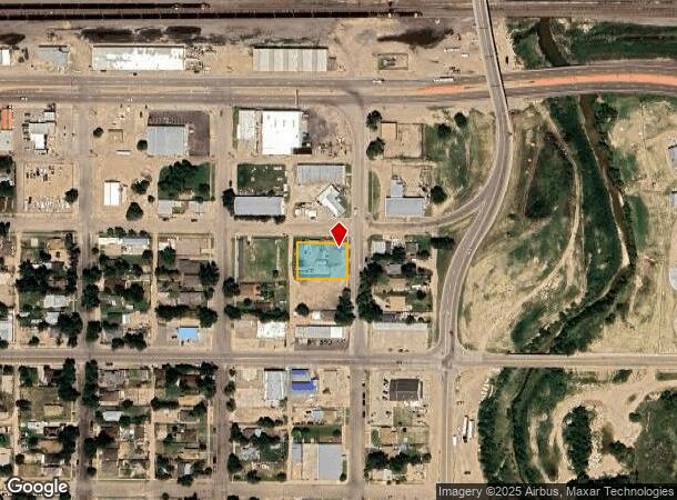
Property Record
202 Bradish Ave, La Junta, CO 81050
NEARBY LISTINGS FOR SALE OR LEASE
Property Detail
202 Bradish Ave
Other Market Areas
Bradish Addition
4643-024-20001
LOTS 1 TO 4 BLK 21 LJ BRADISH B1061 P285; MS# 533C BY MIS; RCPTN-528802 #633087-QC; BL- LT- SEC- 2 TWN- 24 RNG- 55
Commercialnec
Otero
2024
Colorado
2024
1-4
968600
0.32 AC
2,256 SF
Colorado East Area
DEMOGRAPHICS near 202 Bradish Ave
1 mile
3 mile
5 mile
2024 Total Population
4,775
8,395
8,759
2029 Population
4,703
8,227
8,579
Pop Growth 2024-2029
(1.51%)
(2.00%)
(2.06%)
Average Age
39
40
40
2024 Total Households
1,962
3,444
3,588
HH Growth 2024-2029
(1.63%)
(2.09%)
(2.15%)
Median Household Inc
$47,097
$50,953
$51,184
Avg Household Size
2.30
2.30
2.30
2024 Avg HH Vehicles
2.00
2.00
2.00
Median Home Value
$88,486
$120,000
$123,208
Median Year Built
1949
1965
1965
Nearby Places
Map Layers
Map Styles
 Street
 Aerial
Transit
 Traffic
 Biking
Places
Listings with unknown addresses are not visible on the map
- Restaurants
- Banks
- Shops
- Fitness
- Groceries
PUBLIC TRANSPORTATION
COMMUTER RAIL
Drive
Walk
Distance
2 min
12 min
0.6 mi
Nearby Properties
Address
Land Use
TOTAL SIZE
Lot Size
Zoning
Address
Land Use
TOTAL SIZE
Lot Size
Zoning
17,669 SF
6.64 AC
Address
Land Use
TOTAL SIZE
Lot Size
Zoning
31,827 SF
2.13 AC
Address
Land Use
TOTAL SIZE
Lot Size
Zoning
5,225 SF
2.07 AC
Address
Land Use
TOTAL SIZE
Lot Size
Zoning
2,091 SF
2.54 AC
Address
Land Use
TOTAL SIZE
Lot Size
Zoning
43,000 SF
28.30 AC
Address
Land Use
TOTAL SIZE
Lot Size
Zoning
15,433 SF
1.76 AC
Address
Land Use
TOTAL SIZE
Lot Size
Zoning
91,625 SF
Address
Land Use
TOTAL SIZE
Lot Size
Zoning
69,087 SF
8.28 AC
Address
Land Use
TOTAL SIZE
Lot Size
Zoning
40,238 SF
1.86 AC
Address
Land Use
TOTAL SIZE
Lot Size
Zoning
24,228 SF
3.10 AC
Address
Land Use
TOTAL SIZE
Lot Size
Zoning
38,891 SF
7.60 AC
Address
Land Use
TOTAL SIZE
Lot Size
Zoning
32,615 SF
1.75 AC
Address
Land Use
TOTAL SIZE
Lot Size
Zoning
32,742 SF
3.37 AC
Address
Land Use
TOTAL SIZE
Lot Size
Zoning
37,830 SF
0.79 AC
Address
Land Use
TOTAL SIZE
Lot Size
Zoning
28,194 SF
2.42 AC
Address
Land Use
TOTAL SIZE
Lot Size
Zoning
64,848 SF
4.58 AC
Address
Land Use
TOTAL SIZE
Lot Size
Zoning
14,034 SF
2.02 AC
Address
Land Use
TOTAL SIZE
Lot Size
Zoning
2,080 SF
27.56 AC
Address
Land Use
TOTAL SIZE
Lot Size
Zoning
22,700 SF
2.82 AC
Address
Land Use
TOTAL SIZE
Lot Size
Zoning
24,805 SF
3.85 AC
Address
Land Use
TOTAL SIZE
Lot Size
Zoning
12,000 SF
1.14 AC
Address
Land Use
TOTAL SIZE
Lot Size
Zoning
12,500 SF
13.20 AC
Address
Land Use
TOTAL SIZE
Lot Size
Zoning
92,124 SF
Address
Land Use
TOTAL SIZE
Lot Size
Zoning
30,150 SF
Address
Land Use
TOTAL SIZE
Lot Size
Zoning
10,834 SF
2.01 AC
Address
Land Use
TOTAL SIZE
Lot Size
Zoning
18,547 SF
0.96 AC
Address
Land Use
TOTAL SIZE
Lot Size
Zoning
5,280 SF
0.95 AC
Address
Land Use
TOTAL SIZE
Lot Size
Zoning
34,203 SF
2.07 AC
Address
Land Use
TOTAL SIZE
Lot Size
Zoning
16,881 SF
1.17 AC
Address
Land Use
TOTAL SIZE
Lot Size
Zoning
11,460 SF
0.68 AC
The World's #1 Commercial Real Estate Marketplace
Connect with us
© 2026 CoStar Group
The information above has been obtained from sources believed reliable. While we do not doubt its accuracy we have not verified it and make no guarantee, warranty or representation about it. It is your responsibility to independently confirm its accuracy and completeness. Any projections, opinions, assumptions, or estimates used are for example only and do not represent the current or future performance of the property. The value of this transaction to you depends on tax and other factors which should be evaluated by your tax, financial, and legal advisors. You and your advisors should conduct a careful, independent investigation of the property to determine to your satisfaction the suitability of the property for your needs.