Property Record
202 Daily Rd, Rosenberg, TX 77471
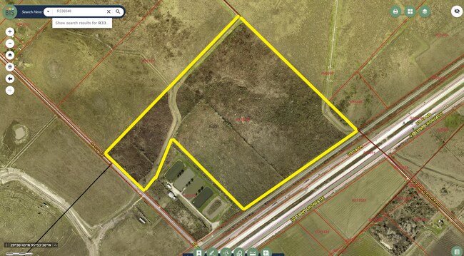

Property Detail
202 Daily Rd
Houston-Pasadena-The Woodlands, TX
0331 S A AND M G, ACRES 72.5534, BLOCK 58, SLAVIN & GEORGE
0331-00-058-0010-901
FORT BEND
Commercialnec
Texas
A Areas with a 1% annual chance of flooding and a 26% chance of flooding over the life of a 30-year mortgage.
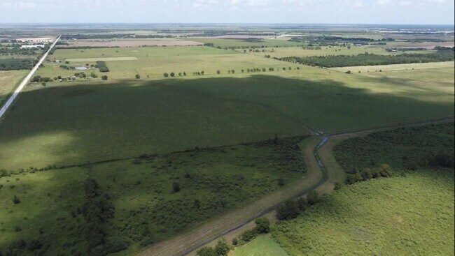
72.55 AC
2024
Southwest Outlier
2025
Houston
675300
NEARBY LISTINGS FOR SALE OR LEASE
DEMOGRAPHICS near 202 Daily Rd
1 mile
3 mile
5 mile
2025 Total Population
10
4,233
17,708
2030 Population
12
4,894
20,328
Pop Growth 2025-2030
+ 20.00%
+ 15.62%
+ 14.80%
Average Age
33
38
37
2025 Total Households
3
1,370
5,557
HH Growth 2025-2030
+ 33.33%
+ 15.99%
+ 15.24%
Median Household Inc
$0
$72,216
$74,906
Avg Household Size
3.00
3.10
3.20
2025 Avg HH Vehicles
2.00
2.00
2.00
Median Home Value
$99,999
$433,735
$291,142
Median Year Built
1989
1990
2003
Nearby Places
Map Layers
Map Styles
 Street
 Aerial
Layers
 Traffic
 Biking
Places
Listings with unknown addresses are not visible on the map
- Restaurants
- Banks
- Shops
- Fitness
- Groceries
SALE & LEASE HISTORY
LISTING DATE
SALE/LEASE

Nov 07, 2022
For Sale
Jun 14, 2020
For Sale
Nearby Properties
Address
Land Use
TOTAL SIZE
Lot Size
Zoning
Address
Land Use
TOTAL SIZE
Lot Size
Zoning
146.35 AC
ST
Address
Land Use
TOTAL SIZE
Lot Size
Zoning
672 SF
230.34 AC
YT
Address
Land Use
TOTAL SIZE
Lot Size
Zoning
37.08 AC
Address
Land Use
TOTAL SIZE
Lot Size
Zoning
100,000 SF
1.32 AC
Address
Land Use
TOTAL SIZE
Lot Size
Zoning
19.57 AC
OY
Address
Land Use
TOTAL SIZE
Lot Size
Zoning
208.52 AC
OST
Address
Land Use
TOTAL SIZE
Lot Size
Zoning
194.64 AC
Address
Land Use
TOTAL SIZE
Lot Size
Zoning
9.51 AC
Address
Land Use
TOTAL SIZE
Lot Size
Zoning
11,800 SF
9.26 AC
S
Address
Land Use
TOTAL SIZE
Lot Size
Zoning
105,350 SF
11.50 AC
R
Address
Land Use
TOTAL SIZE
Lot Size
Zoning
129.15 AC
Address
Land Use
TOTAL SIZE
Lot Size
Zoning
1,064 SF
68.45 AC
OQY
Address
Land Use
TOTAL SIZE
Lot Size
Zoning
51,250 SF
10.01 AC
S
Address
Land Use
TOTAL SIZE
Lot Size
Zoning
2,064 SF
93.87 AC
QO
Address
Land Use
TOTAL SIZE
Lot Size
Zoning
10,737 SF
8.26 AC
Address
Land Use
TOTAL SIZE
Lot Size
Zoning
75.19 AC
Address
Land Use
TOTAL SIZE
Lot Size
Zoning
159.79 AC
OTYM
Address
Land Use
TOTAL SIZE
Lot Size
Zoning
21.35 AC
S
Address
Land Use
TOTAL SIZE
Lot Size
Zoning
Address
Land Use
TOTAL SIZE
Lot Size
Zoning
40,876 SF
7.69 AC
S
Address
Land Use
TOTAL SIZE
Lot Size
Zoning
33,106 SF
6 AC
J
Address
Land Use
TOTAL SIZE
Lot Size
Zoning
35 AC
S
Address
Land Use
TOTAL SIZE
Lot Size
Zoning
13,200 SF
2.20 AC
S
Address
Land Use
TOTAL SIZE
Lot Size
Zoning
13,920 SF
3 AC
SM
Address
Land Use
TOTAL SIZE
Lot Size
Zoning
28,690 SF
4.01 AC
J
Address
Land Use
TOTAL SIZE
Lot Size
Zoning
11.54 AC
TS
Address
Land Use
TOTAL SIZE
Lot Size
Zoning
20,785 SF
10 AC
QS
Address
Land Use
TOTAL SIZE
Lot Size
Zoning
15,396 SF
3.27 AC
Address
Land Use
TOTAL SIZE
Lot Size
Zoning
30,000 SF
41.20 AC
YT
The World's #1 Commercial Real Estate Marketplace
Connect with us
© 2026 CoStar Group
The information above has been obtained from sources believed reliable. While we do not doubt its accuracy we have not verified it and make no guarantee, warranty or representation about it. It is your responsibility to independently confirm its accuracy and completeness. Any projections, opinions, assumptions, or estimates used are for example only and do not represent the current or future performance of the property. The value of this transaction to you depends on tax and other factors which should be evaluated by your tax, financial, and legal advisors. You and your advisors should conduct a careful, independent investigation of the property to determine to your satisfaction the suitability of the property for your needs.