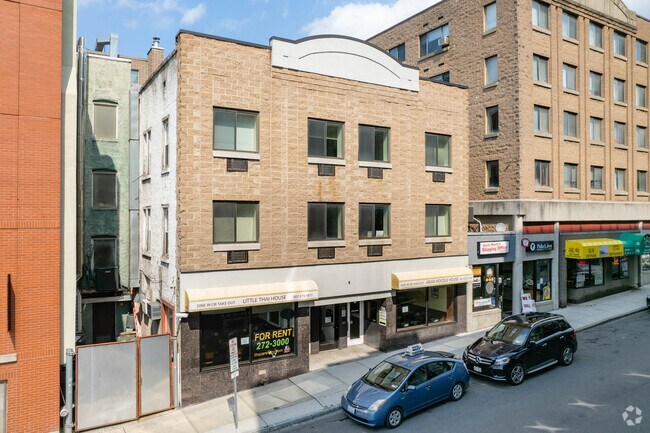
Property Record
202 Dryden Rd, Ithaca, NY 14850


Property Detail
202 Dryden Rd
500700-064-000-0002-027-000-0000
Tompkins
Apartment
New York
B-2B
27.000
B and X Area of moderate flood hazard, usually the area between the limits of the 100-year and 500-year floods.
0.06 AC
2025
Collegetown
2024
Other Market Areas
000201
Ithaca, NY
9,000 SF
NEARBY LISTINGS FOR SALE OR LEASE
DEMOGRAPHICS near 202 Dryden Rd
1 mile
3 mile
5 mile
2025 Total Population
23,330
59,185
68,270
2030 Population
23,314
59,420
68,458
Pop Growth 2025-2030
(0.07%)
+ 0.40%
+ 0.28%
Average Age
31
34
35
2025 Total Households
9,639
21,890
25,940
HH Growth 2025-2030
(0.16%)
+ 0.37%
+ 0.22%
Median Household Inc
$48,546
$59,075
$63,923
Avg Household Size
1.90
2.00
2.00
2025 Avg HH Vehicles
1.00
1.00
1.00
Median Home Value
$387,007
$350,933
$346,033
Median Year Built
1977
1973
1975
Nearby Places
Map Layers
Map Styles
 Street
 Aerial
Transit
 Traffic
 Biking
Places
Listings with unknown addresses are not visible on the map
- Restaurants
- Banks
- Shops
- Fitness
- Groceries
PUBLIC TRANSPORTATION
AIRPORT
Ithaca Tompkins International
Drive
Walk
Distance
Ithaca Tompkins International
16 min
7.3 mi
Elmira/Corning Regional
Drive
Walk
Distance
Elmira/Corning Regional
48 min
34.0 mi
SALE & LEASE HISTORY
LISTING DATE
SALE/LEASE

Aug 17, 2021
For Lease
Nearby Properties
Address
Land Use
TOTAL SIZE
Lot Size
Zoning
Address
Land Use
TOTAL SIZE
Lot Size
Zoning
5,000 SF
154.28 AC
U-1
Address
Land Use
TOTAL SIZE
Lot Size
Zoning
2,212,226 SF
588.22 AC
Address
Land Use
TOTAL SIZE
Lot Size
Zoning
43 AC
Address
Land Use
TOTAL SIZE
Lot Size
Zoning
378,445 SF
4.39 AC
Address
Land Use
TOTAL SIZE
Lot Size
Zoning
338,706 SF
2.08 AC
U-1
Address
Land Use
TOTAL SIZE
Lot Size
Zoning
276,302 SF
15.94 AC
Address
Land Use
TOTAL SIZE
Lot Size
Zoning
1.30 AC
U-1
Address
Land Use
TOTAL SIZE
Lot Size
Zoning
50,319 SF
25.92 AC
Address
Land Use
TOTAL SIZE
Lot Size
Zoning
19,600 SF
22.51 AC
P-1
Address
Land Use
TOTAL SIZE
Lot Size
Zoning
218,211 SF
0.76 AC
CBD-60
Address
Land Use
TOTAL SIZE
Lot Size
Zoning
150,015 SF
4.94 AC
U-1
Address
Land Use
TOTAL SIZE
Lot Size
Zoning
4,400 SF
30.50 AC
Address
Land Use
TOTAL SIZE
Lot Size
Zoning
199,578 SF
0.56 AC
CBD-60
Address
Land Use
TOTAL SIZE
Lot Size
Zoning
364,128 SF
107.14 AC
Address
Land Use
TOTAL SIZE
Lot Size
Zoning
20,834 SF
32.98 AC
Address
Land Use
TOTAL SIZE
Lot Size
Zoning
140,488 SF
5.90 AC
Address
Land Use
TOTAL SIZE
Lot Size
Zoning
131,532 SF
2.20 AC
U-1
Address
Land Use
TOTAL SIZE
Lot Size
Zoning
93,573 SF
0.91 AC
Address
Land Use
TOTAL SIZE
Lot Size
Zoning
8,100 SF
0.51 AC
CBD-60
Address
Land Use
TOTAL SIZE
Lot Size
Zoning
116,854 SF
1.16 AC
Address
Land Use
TOTAL SIZE
Lot Size
Zoning
115,796 SF
26.51 AC
Address
Land Use
TOTAL SIZE
Lot Size
Zoning
0.93 AC
U-1
Address
Land Use
TOTAL SIZE
Lot Size
Zoning
228,978 SF
4.96 AC
Address
Land Use
TOTAL SIZE
Lot Size
Zoning
130,781 SF
20.10 AC
Address
Land Use
TOTAL SIZE
Lot Size
Zoning
75,168 SF
22.92 AC
Address
Land Use
TOTAL SIZE
Lot Size
Zoning
3,000 SF
97.73 AC
Address
Land Use
TOTAL SIZE
Lot Size
Zoning
112,392 SF
0.76 AC
B-2B
Address
Land Use
TOTAL SIZE
Lot Size
Zoning
185,997 SF
0.17 AC
CBD-140
Address
Land Use
TOTAL SIZE
Lot Size
Zoning
26,658 SF
0.69 AC
R-3A
The World's #1 Commercial Real Estate Marketplace
Connect with us
© 2026 CoStar Group
The information above has been obtained from sources believed reliable. While we do not doubt its accuracy we have not verified it and make no guarantee, warranty or representation about it. It is your responsibility to independently confirm its accuracy and completeness. Any projections, opinions, assumptions, or estimates used are for example only and do not represent the current or future performance of the property. The value of this transaction to you depends on tax and other factors which should be evaluated by your tax, financial, and legal advisors. You and your advisors should conduct a careful, independent investigation of the property to determine to your satisfaction the suitability of the property for your needs.