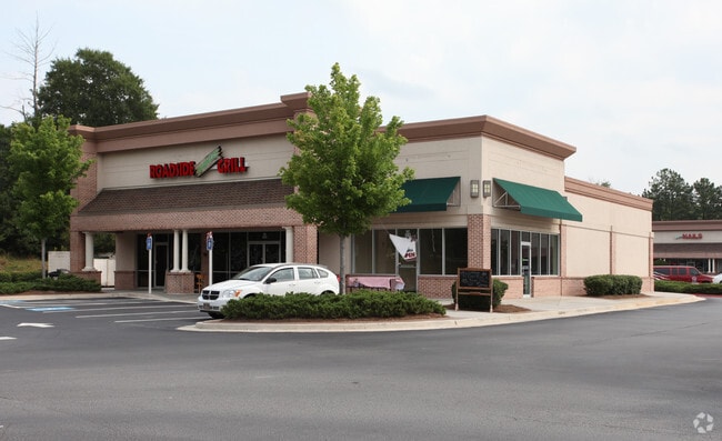
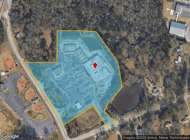
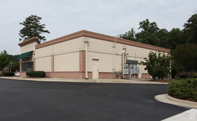
Property Record
202 E Atlanta Rd, Stockbridge, GA 30281
NEARBY LISTINGS FOR SALE OR LEASE
Property Detail
202 E Atlanta Rd
Atlanta-Sandy Springs-Roswell, GA
Stockbridge Lakes
0S24-01-001-000
LAND LOT: 68 /LAND DISTRICT: 12
Regionalshoppingcenterormallwithanchorstore
Henry
X
Georgia
13151C0086D
69
2025
13.66 AC
2025
Forest Park/Morrow
070113
Atlanta
72,808 SF
DEMOGRAPHICS near 202 E Atlanta Rd
1 Mile
3 Mile
5 Mile
2024 Total Population
4,455
47,236
117,052
2029 Population
4,872
50,144
122,607
Pop Growth 2024-2029
+ 9.36%
+ 6.16%
+ 4.75%
Average Age
37
37
38
2024 Total Households
1,578
17,277
41,651
HH Growth 2024-2029
+ 9.32%
+ 6.12%
+ 4.76%
Median Household Inc
$49,708
$57,818
$64,682
Avg Household Size
2.80
2.70
2.70
2024 Avg HH Vehicles
2.00
2.00
2.00
Median Home Value
$147,052
$178,522
$206,418
Median Year Built
1988
1994
1993
Nearby Places
Map Layers
Map Styles
 Street
 Aerial
- Restaurants
- Banks
- Shops
- Fitness
- Groceries
PUBLIC TRANSPORTATION
AIRPORT
Hartsfield - Jackson Atlanta International
DRIVE
WALK
Distance
Hartsfield - Jackson Atlanta International
27 min
16.7 mi
SALE & LEASE HISTORY
LISTING DATE
SALE/LEASE

Sep 05, 2024
For Lease
Sep 05, 2024
For Lease
Nearby Properties
Address
Land Use
TOTAL SIZE
Lot Size
Zoning
Address
Land Use
TOTAL SIZE
Lot Size
Zoning
368 SF
42.85 AC
RM
Address
Land Use
TOTAL SIZE
Lot Size
Zoning
35,082 SF
31.82 AC
C3
Address
Land Use
TOTAL SIZE
Lot Size
Zoning
4,010 SF
37.60 AC
C2
Address
Land Use
TOTAL SIZE
Lot Size
Zoning
17,862 SF
30 AC
PD
Address
Land Use
TOTAL SIZE
Lot Size
Zoning
19,140 SF
40.11 AC
RM
Address
Land Use
TOTAL SIZE
Lot Size
Zoning
21,678 SF
26.44 AC
RM
Address
Land Use
TOTAL SIZE
Lot Size
Zoning
707,800 SF
27.81 AC
M1
Address
Land Use
TOTAL SIZE
Lot Size
Zoning
2,426 SF
19.79 AC
RM
Address
Land Use
TOTAL SIZE
Lot Size
Zoning
284 SF
29 AC
RM
Address
Land Use
TOTAL SIZE
Lot Size
Zoning
25,952 SF
28.88 AC
RM
Address
Land Use
TOTAL SIZE
Lot Size
Zoning
9,264 SF
26.63 AC
RM
Address
Land Use
TOTAL SIZE
Lot Size
Zoning
25,508 SF
26.03 AC
RM
Address
Land Use
TOTAL SIZE
Lot Size
Zoning
20.65 AC
RM
Address
Land Use
TOTAL SIZE
Lot Size
Zoning
439,225 SF
19.81 AC
M1
Address
Land Use
TOTAL SIZE
Lot Size
Zoning
182 SF
19.46 AC
RM
Address
Land Use
TOTAL SIZE
Lot Size
Zoning
158 SF
15.59 AC
RM
Address
Land Use
TOTAL SIZE
Lot Size
Zoning
1,638 SF
12.79 AC
RM
Address
Land Use
TOTAL SIZE
Lot Size
Zoning
391,708 SF
20.04 AC
C2
Address
Land Use
TOTAL SIZE
Lot Size
Zoning
127,735 SF
20.74 AC
M1
Address
Land Use
TOTAL SIZE
Lot Size
Zoning
26,018 SF
11.03 AC
GB
Address
Land Use
TOTAL SIZE
Lot Size
Zoning
8,590 SF
11.09 AC
R3
Address
Land Use
TOTAL SIZE
Lot Size
Zoning
14,862 SF
10.18 AC
GB
Address
Land Use
TOTAL SIZE
Lot Size
Zoning
466,048 SF
6.51 AC
RA
Address
Land Use
TOTAL SIZE
Lot Size
Zoning
102 SF
16.95 AC
RM
Address
Land Use
TOTAL SIZE
Lot Size
Zoning
83,397 SF
1.87 AC
C1
Address
Land Use
TOTAL SIZE
Lot Size
Zoning
83,900 SF
9.66 AC
C3
Address
Land Use
TOTAL SIZE
Lot Size
Zoning
131,920 SF
11.23 AC
GB
Address
Land Use
TOTAL SIZE
Lot Size
Zoning
46,186 SF
9.99 AC
C2
Address
Land Use
TOTAL SIZE
Lot Size
Zoning
126,237 SF
13.76 AC
C3
Address
Land Use
TOTAL SIZE
Lot Size
Zoning
201,480 SF
26.08 AC
The World's #1 Commercial Real Estate Marketplace
Connect with us
© 2026 CoStar Group
The information above has been obtained from sources believed reliable. While we do not doubt its accuracy we have not verified it and make no guarantee, warranty or representation about it. It is your responsibility to independently confirm its accuracy and completeness. Any projections, opinions, assumptions, or estimates used are for example only and do not represent the current or future performance of the property. The value of this transaction to you depends on tax and other factors which should be evaluated by your tax, financial, and legal advisors. You and your advisors should conduct a careful, independent investigation of the property to determine to your satisfaction the suitability of the property for your needs.