Property Record
202 E Gretna Rd, Gretna, VA 24557
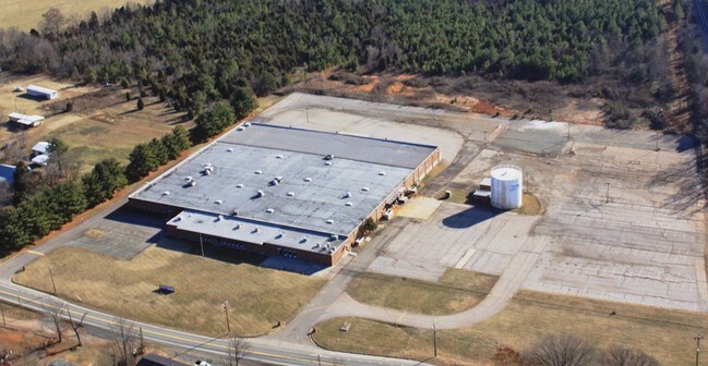
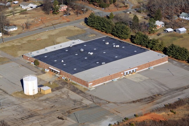
Property Detail
202 E Gretna Rd
2530-25-0011
ST RD 40 8.02 AC
Industrialgeneral
Pittsylvania
TZ
Virginia
B and X Area of moderate flood hazard, usually the area between the limits of the 100-year and 500-year floods.
8.02 AC
2025
Virginia South Central
2025
Other Market Areas
010600
Danville, VA
NEARBY LISTINGS FOR SALE OR LEASE
DEMOGRAPHICS near 202 E Gretna Rd
1 mile
3 mile
5 mile
2025 Total Population
1,195
2,936
4,740
2030 Population
1,156
2,871
4,651
Pop Growth 2025-2030
(3.26%)
(2.21%)
(1.88%)
Average Age
44
46
46
2025 Total Households
550
1,313
2,102
HH Growth 2025-2030
(3.45%)
(2.36%)
(1.95%)
Median Household Inc
$41,160
$41,262
$41,955
Avg Household Size
2.10
2.20
2.20
2025 Avg HH Vehicles
2.00
2.00
2.00
Median Home Value
$141,319
$138,938
$140,302
Median Year Built
1971
1973
1974
Nearby Places
Map Layers
Map Styles
 Street
 Aerial
Layers
 Traffic
 Biking
Places
Listings with unknown addresses are not visible on the map
- Restaurants
- Banks
- Shops
- Fitness
- Groceries
PUBLIC TRANSPORTATION
AIRPORT
Lynchburg Regional/Preston Glenn Field
Drive
Walk
Distance
Lynchburg Regional/Preston Glenn Field
48 min
34.2 mi
SALE & LEASE HISTORY
LISTING DATE
SALE/LEASE

Sep 24, 2016
For Sale
May 03, 2017
For Lease
Nearby Properties
Address
Land Use
TOTAL SIZE
Lot Size
Zoning
Address
Land Use
TOTAL SIZE
Lot Size
Zoning
29 AC
TZ
Address
Land Use
TOTAL SIZE
Lot Size
Zoning
12.36 AC
TZ
Address
Land Use
TOTAL SIZE
Lot Size
Zoning
30 AC
TZ
Address
Land Use
TOTAL SIZE
Lot Size
Zoning
14.01 AC
TZ
Address
Land Use
TOTAL SIZE
Lot Size
Zoning
44.35 AC
A-1
Address
Land Use
TOTAL SIZE
Lot Size
Zoning
7.63 AC
TZ
Address
Land Use
TOTAL SIZE
Lot Size
Zoning
4.01 AC
TZ
Address
Land Use
TOTAL SIZE
Lot Size
Zoning
129,240 SF
12.26 AC
M-2
Address
Land Use
TOTAL SIZE
Lot Size
Zoning
61,320 SF
14.02 AC
M-2
Address
Land Use
TOTAL SIZE
Lot Size
Zoning
14,738 SF
0.80 AC
TZ
Address
Land Use
TOTAL SIZE
Lot Size
Zoning
12,089 SF
5.17 AC
B-2
Address
Land Use
TOTAL SIZE
Lot Size
Zoning
5.08 AC
TZ
Address
Land Use
TOTAL SIZE
Lot Size
Zoning
3,038 SF
3.59 AC
TZ
Address
Land Use
TOTAL SIZE
Lot Size
Zoning
2.55 AC
TZ
Address
Land Use
TOTAL SIZE
Lot Size
Zoning
4,370 SF
1.44 AC
TZ
Address
Land Use
TOTAL SIZE
Lot Size
Zoning
142.20 AC
A-1
Address
Land Use
TOTAL SIZE
Lot Size
Zoning
9,808 SF
1.23 AC
TZ
Address
Land Use
TOTAL SIZE
Lot Size
Zoning
7,660 SF
2.50 AC
TZ
Address
Land Use
TOTAL SIZE
Lot Size
Zoning
6,397 SF
3.45 AC
TZ
Address
Land Use
TOTAL SIZE
Lot Size
Zoning
4,231 SF
0.37 AC
TZ
Address
Land Use
TOTAL SIZE
Lot Size
Zoning
53,652 SF
8.93 AC
M-1
Address
Land Use
TOTAL SIZE
Lot Size
Zoning
9,840 SF
0.58 AC
B-2
Address
Land Use
TOTAL SIZE
Lot Size
Zoning
6,264 SF
0.78 AC
TZ
Address
Land Use
TOTAL SIZE
Lot Size
Zoning
8,528 SF
0.96 AC
TZ
Address
Land Use
TOTAL SIZE
Lot Size
Zoning
4,808 SF
0.96 AC
TZ
Address
Land Use
TOTAL SIZE
Lot Size
Zoning
5,040 SF
0.12 AC
TZ
Address
Land Use
TOTAL SIZE
Lot Size
Zoning
4,677 SF
0.26 AC
TZ
Address
Land Use
TOTAL SIZE
Lot Size
Zoning
6,433 SF
1.07 AC
TZ
Address
Land Use
TOTAL SIZE
Lot Size
Zoning
15,214 SF
0.90 AC
TZ
The World's #1 Commercial Real Estate Marketplace
Connect with us
© 2026 CoStar Group
The information above has been obtained from sources believed reliable. While we do not doubt its accuracy we have not verified it and make no guarantee, warranty or representation about it. It is your responsibility to independently confirm its accuracy and completeness. Any projections, opinions, assumptions, or estimates used are for example only and do not represent the current or future performance of the property. The value of this transaction to you depends on tax and other factors which should be evaluated by your tax, financial, and legal advisors. You and your advisors should conduct a careful, independent investigation of the property to determine to your satisfaction the suitability of the property for your needs.