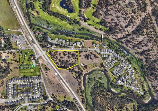
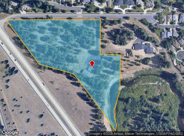
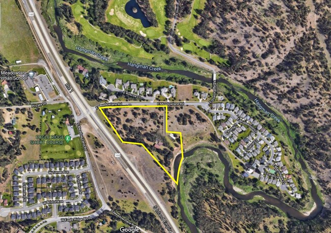
Property Record
202 E Meadowlane Rd, Spokane, WA 99224
NEARBY LISTINGS FOR SALE OR LEASE
Property Detail
202 E Meadowlane Rd
34053.0023
Latah Creek
Religious
05-24-43; PTN OF N1/2 OF SW1/4 DAF; BNG NW COR OF SW1/4; TH S002144W 60.01FT; TH N892638E 510.26FT TO POB; TH N892638E 310FT; TH S003322E 300FT; TH N892638E 175FT; TH S003322E TO C/L OF LATAH CREEK; TH SWLY AND SLY ALG SD C/L TO NW ROW LN OF SR195; T
AE
Spokane
53063C0706D
Washington
2025
9.50 AC
2025
South Hill
003900
Spokane
1,744 SF
Spokane-Spokane Valley, WA
DEMOGRAPHICS near 202 E Meadowlane Rd
1 mile
3 mile
5 mile
2024 Total Population
4,661
52,551
123,335
2029 Population
4,968
55,973
131,749
Pop Growth 2024-2029
+ 6.59%
+ 6.51%
+ 6.82%
Average Age
42
42
41
2024 Total Households
1,732
22,208
52,784
HH Growth 2024-2029
+ 6.81%
+ 6.70%
+ 7.22%
Median Household Inc
$128,302
$84,091
$65,357
Avg Household Size
2.70
2.30
2.20
2024 Avg HH Vehicles
2.00
2.00
2.00
Median Home Value
$524,398
$456,489
$408,031
Median Year Built
2002
1978
1974
Nearby Places
Map Layers
Map Styles
 Street
 Aerial
Transit
 Traffic
 Biking
Places
Listings with unknown addresses are not visible on the map
- Restaurants
- Banks
- Shops
- Fitness
- Groceries
PUBLIC TRANSPORTATION
COMMUTER RAIL
Drive
Walk
Distance
11 min
6.4 mi
AIRPORT
Spokane International
Drive
Walk
Distance
Spokane International
14 min
8.6 mi
SALE & LEASE HISTORY
LISTING DATE
SALE/LEASE

Aug 27, 2021
For Sale
Nearby Properties
Address
Land Use
TOTAL SIZE
Lot Size
Zoning
Address
Land Use
TOTAL SIZE
Lot Size
Zoning
226,702 SF
49.25 AC
RSF
Address
Land Use
TOTAL SIZE
Lot Size
Zoning
365,804 SF
16.13 AC
RSF
Address
Land Use
TOTAL SIZE
Lot Size
Zoning
270,262 SF
29.10 AC
Address
Land Use
TOTAL SIZE
Lot Size
Zoning
218,684 SF
13.29 AC
RMF
Address
Land Use
TOTAL SIZE
Lot Size
Zoning
124,234 SF
13.54 AC
RSF
Address
Land Use
TOTAL SIZE
Lot Size
Zoning
210,277 SF
19.18 AC
RMF
Address
Land Use
TOTAL SIZE
Lot Size
Zoning
289,573 SF
7.73 AC
RMF
Address
Land Use
TOTAL SIZE
Lot Size
Zoning
135,715 SF
4.73 AC
RMF
Address
Land Use
TOTAL SIZE
Lot Size
Zoning
119,933 SF
5.61 AC
Address
Land Use
TOTAL SIZE
Lot Size
Zoning
159,720 SF
6.84 AC
RMF
Address
Land Use
TOTAL SIZE
Lot Size
Zoning
78,990 SF
5.58 AC
RSF
Address
Land Use
TOTAL SIZE
Lot Size
Zoning
173,714 SF
9.98 AC
HDR
Address
Land Use
TOTAL SIZE
Lot Size
Zoning
142,500 SF
6.86 AC
RMF
Address
Land Use
TOTAL SIZE
Lot Size
Zoning
59,826 SF
6.79 AC
RSF
Address
Land Use
TOTAL SIZE
Lot Size
Zoning
55,623 SF
4.46 AC
MU
Address
Land Use
TOTAL SIZE
Lot Size
Zoning
130,878 SF
5.57 AC
CC2
Address
Land Use
TOTAL SIZE
Lot Size
Zoning
144,382 SF
5.43 AC
CC2
Address
Land Use
TOTAL SIZE
Lot Size
Zoning
105,728 SF
4.53 AC
RMF
Address
Land Use
TOTAL SIZE
Lot Size
Zoning
121,962 SF
3.80 AC
RMF
Address
Land Use
TOTAL SIZE
Lot Size
Zoning
108,609 SF
4.11 AC
MU
Address
Land Use
TOTAL SIZE
Lot Size
Zoning
175,671 SF
10.89 AC
RSF
Address
Land Use
TOTAL SIZE
Lot Size
Zoning
117,668 SF
7.52 AC
CC2
Address
Land Use
TOTAL SIZE
Lot Size
Zoning
111,808 SF
5.65 AC
RMF
Address
Land Use
TOTAL SIZE
Lot Size
Zoning
48,003 SF
1.72 AC
RSF
Address
Land Use
TOTAL SIZE
Lot Size
Zoning
164,592 SF
12.01 AC
RMF
Address
Land Use
TOTAL SIZE
Lot Size
Zoning
265,644 SF
8.45 AC
RMF
Address
Land Use
TOTAL SIZE
Lot Size
Zoning
134,016 SF
8.01 AC
CC2
Address
Land Use
TOTAL SIZE
Lot Size
Zoning
91,833 SF
9.48 AC
MU
Address
Land Use
TOTAL SIZE
Lot Size
Zoning
79,855 SF
4.13 AC
RMF
Address
Land Use
TOTAL SIZE
Lot Size
Zoning
109,304 SF
5.13 AC
RSF
The World's #1 Commercial Real Estate Marketplace
Connect with us
© 2026 CoStar Group
The information above has been obtained from sources believed reliable. While we do not doubt its accuracy we have not verified it and make no guarantee, warranty or representation about it. It is your responsibility to independently confirm its accuracy and completeness. Any projections, opinions, assumptions, or estimates used are for example only and do not represent the current or future performance of the property. The value of this transaction to you depends on tax and other factors which should be evaluated by your tax, financial, and legal advisors. You and your advisors should conduct a careful, independent investigation of the property to determine to your satisfaction the suitability of the property for your needs.