Property Record
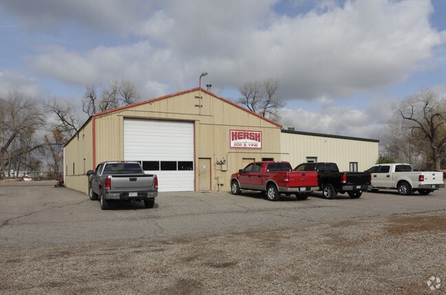
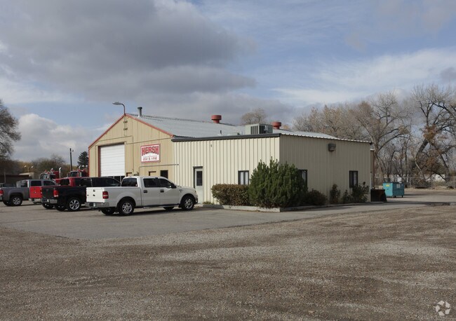
202 E Vine Dr, Fort Collins, CO 80524

Property Detail
202 E Vine Dr
97013-00-021
BEG AT PT WH BEARS N 89 59 E 230 FT, N 25 FT FROM SW COR 1-7-69, N 350.15 FT TO PT ON S BANK OF LAKE CANAL, TH ALG S BANK SD CANAL S 77 32 E 167.76 FT, S 81 5 E 152.13 FT, S 83 38 E 319.9 FT, TH LEAV SD CANAL S 254.68 FT, S 89 59 W 632.03 FT TO BEG,
Commercialnec
LARIMER
CCN
Colorado
AE The base floodplain where base flood elevations are provided. AE Zones are now used on new format FIRMs instead of A1-A30 Zones.
4.02 AC
2024
Fort Collins/Loveland
2025
Denver
001305
Fort Collins-Loveland, CO
4,540 SF
NEARBY LISTINGS FOR SALE OR LEASE
DEMOGRAPHICS near 202 E Vine Dr
1 mile
3 mile
5 mile
2025 Total Population
9,142
81,499
152,927
2030 Population
9,559
84,853
158,321
Pop Growth 2025-2030
+ 4.56%
+ 4.12%
+ 3.53%
Average Age
37
34
36
2025 Total Households
4,115
32,078
62,024
HH Growth 2025-2030
+ 4.64%
+ 4.83%
+ 3.98%
Median Household Inc
$61,479
$63,080
$73,049
Avg Household Size
2.10
2.20
2.20
2025 Avg HH Vehicles
2.00
2.00
2.00
Median Home Value
$498,476
$602,617
$584,197
Median Year Built
1992
1984
1987
Nearby Places
Map Layers
Map Styles
 Street
 Aerial
Layers
 Traffic
 Biking
Places
Listings with unknown addresses are not visible on the map
- Restaurants
- Banks
- Shops
- Fitness
- Groceries
Nearby Properties
Address
Land Use
TOTAL SIZE
Lot Size
Zoning
Address
Land Use
TOTAL SIZE
Lot Size
Zoning
850,000 SF
21.76 AC
E
Address
Land Use
TOTAL SIZE
Lot Size
Zoning
1,096,874 SF
72 AC
CSU
Address
Land Use
TOTAL SIZE
Lot Size
Zoning
440,160 SF
29 AC
CSU
Address
Land Use
TOTAL SIZE
Lot Size
Zoning
333,130 SF
47.74 AC
Address
Land Use
TOTAL SIZE
Lot Size
Zoning
397,677 SF
28.87 AC
FA
Address
Land Use
TOTAL SIZE
Lot Size
Zoning
521,085 SF
80.60 AC
CSU
Address
Land Use
TOTAL SIZE
Lot Size
Zoning
172,211 SF
1.92 AC
D
Address
Land Use
TOTAL SIZE
Lot Size
Zoning
281,945 SF
15.01 AC
NCL
Address
Land Use
TOTAL SIZE
Lot Size
Zoning
170,119 SF
12.83 AC
C
Address
Land Use
TOTAL SIZE
Lot Size
Zoning
155,149 SF
3.67 AC
D
Address
Land Use
TOTAL SIZE
Lot Size
Zoning
290,000 SF
3.67 AC
D
Address
Land Use
TOTAL SIZE
Lot Size
Zoning
139,965 SF
8.62 AC
CSU
Address
Land Use
TOTAL SIZE
Lot Size
Zoning
191,673 SF
17.39 AC
I
Address
Land Use
TOTAL SIZE
Lot Size
Zoning
211,255 SF
20.73 AC
C
Address
Land Use
TOTAL SIZE
Lot Size
Zoning
71,244 SF
5.96 AC
C
Address
Land Use
TOTAL SIZE
Lot Size
Zoning
400,000 SF
1.31 AC
D
Address
Land Use
TOTAL SIZE
Lot Size
Zoning
97,130 SF
8.48 AC
Address
Land Use
TOTAL SIZE
Lot Size
Zoning
87,563 SF
3.15 AC
Address
Land Use
TOTAL SIZE
Lot Size
Zoning
110,700 SF
44.74 AC
FA
Address
Land Use
TOTAL SIZE
Lot Size
Zoning
107,170 SF
14.61 AC
Address
Land Use
TOTAL SIZE
Lot Size
Zoning
189,920 SF
6 AC
E
Address
Land Use
TOTAL SIZE
Lot Size
Zoning
116,589 SF
0.87 AC
Address
Land Use
TOTAL SIZE
Lot Size
Zoning
69,065 SF
11.67 AC
E
Address
Land Use
TOTAL SIZE
Lot Size
Zoning
94,079 SF
7 AC
NC
Address
Land Use
TOTAL SIZE
Lot Size
Zoning
244,561 SF
9.40 AC
E
Address
Land Use
TOTAL SIZE
Lot Size
Zoning
123,006 SF
10.27 AC
Address
Land Use
TOTAL SIZE
Lot Size
Zoning
367,359 SF
13.36 AC
Address
Land Use
TOTAL SIZE
Lot Size
Zoning
112,289 SF
10.33 AC
CCN
The World's #1 Commercial Real Estate Marketplace
Connect with us
© 2026 CoStar Group
The information above has been obtained from sources believed reliable. While we do not doubt its accuracy we have not verified it and make no guarantee, warranty or representation about it. It is your responsibility to independently confirm its accuracy and completeness. Any projections, opinions, assumptions, or estimates used are for example only and do not represent the current or future performance of the property. The value of this transaction to you depends on tax and other factors which should be evaluated by your tax, financial, and legal advisors. You and your advisors should conduct a careful, independent investigation of the property to determine to your satisfaction the suitability of the property for your needs.