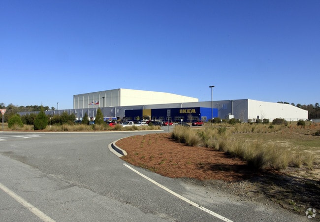
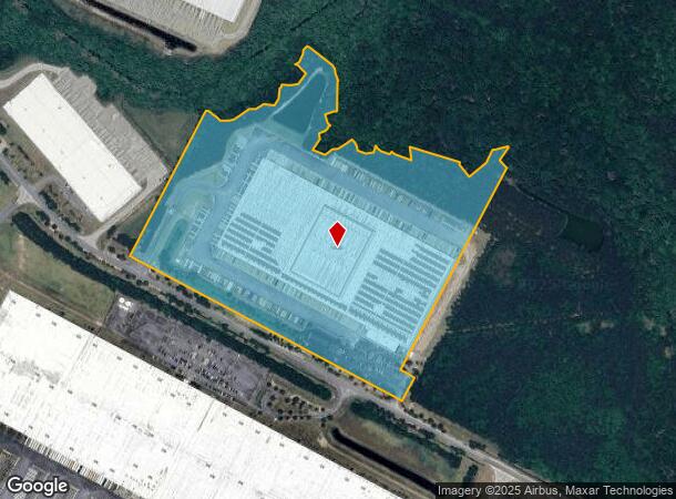
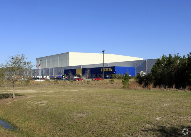
Property Record
202 Little Hearst Pkwy, Port Wentworth, GA 31407
NEARBY LISTINGS FOR SALE OR LEASE
Property Detail
202 Little Hearst Pkwy
1081201006
PARCEL 6A SUB OF PARCEL 6 SAVANN AH RIVER INTERNATIONAL TRADE PA
Warehouse
Chatham
X
Georgia
45053C0475D
52.93 AC
2024
Port Wentworth
2025
Savannah
010701
Savannah, GA
750,480 SF
DEMOGRAPHICS near 202 Little Hearst Pkwy
1 Mile
3 Mile
5 Mile
2024 Total Population
221
10,320
30,620
2029 Population
226
11,014
32,353
Pop Growth 2024-2029
+ 2.26%
+ 6.72%
+ 5.66%
Average Age
42
36
35
2024 Total Households
4
3,482
11,235
HH Growth 2024-2029
0.00%
+ 7.73%
+ 5.95%
Median Household Inc
$42,500
$67,413
$77,615
Avg Household Size
2.80
2.50
2.50
2024 Avg HH Vehicles
1.00
2.00
2.00
Median Home Value
$125,000
$161,127
$195,571
Median Year Built
1994
2006
2009
Nearby Places
- Restaurants
- Banks
- Shops
- Fitness
- Groceries
PUBLIC TRANSPORTATION
AIRPORT
Savannah/Hilton Head International
DRIVE
WALK
Distance
Savannah/Hilton Head International
20 min
8.4 mi
Hilton Head
DRIVE
WALK
Distance
Hilton Head
55 min
39.0 mi
Freight Ports
Georgia Ports - Savannah
DRIVE
WALK
Distance
Georgia Ports - Savannah
16 min
6.8 mi
Nearby Properties
Address
Land Use
TOTAL SIZE
Lot Size
Zoning
Address
Land Use
TOTAL SIZE
Lot Size
Zoning
1,008 SF
150 AC
I-H
Address
Land Use
TOTAL SIZE
Lot Size
Zoning
1,400,224 SF
325.62 AC
I-H
Address
Land Use
TOTAL SIZE
Lot Size
Zoning
1,275,180 SF
0.02 AC
Address
Land Use
TOTAL SIZE
Lot Size
Zoning
1,164,800 SF
86.22 AC
Address
Land Use
TOTAL SIZE
Lot Size
Zoning
1,115,200 SF
81.30 AC
Address
Land Use
TOTAL SIZE
Lot Size
Zoning
1,099,220 SF
206.18 AC
I-H
Address
Land Use
TOTAL SIZE
Lot Size
Zoning
1,003,267 SF
64.07 AC
I-H
Address
Land Use
TOTAL SIZE
Lot Size
Zoning
981,943 SF
69.54 AC
I-H
Address
Land Use
TOTAL SIZE
Lot Size
Zoning
832,000 SF
59.75 AC
I-H
Address
Land Use
TOTAL SIZE
Lot Size
Zoning
800,100 SF
44.51 AC
I-H
Address
Land Use
TOTAL SIZE
Lot Size
Zoning
737,500 SF
49.38 AC
I-1
Address
Land Use
TOTAL SIZE
Lot Size
Zoning
28,128 SF
31.61 AC
RA
Address
Land Use
TOTAL SIZE
Lot Size
Zoning
70,000 SF
71.90 AC
IH
Address
Land Use
TOTAL SIZE
Lot Size
Zoning
752,000 SF
51.18 AC
Address
Land Use
TOTAL SIZE
Lot Size
Zoning
27,420 SF
34.55 AC
R1
Address
Land Use
TOTAL SIZE
Lot Size
Zoning
631,800 SF
38.47 AC
Address
Land Use
TOTAL SIZE
Lot Size
Zoning
285,905 SF
20.16 AC
I-L
Address
Land Use
TOTAL SIZE
Lot Size
Zoning
20,210 SF
85.60 AC
I-H
Address
Land Use
TOTAL SIZE
Lot Size
Zoning
2,156 SF
36.64 AC
PIL
Address
Land Use
TOTAL SIZE
Lot Size
Zoning
515,800 SF
36.16 AC
Address
Land Use
TOTAL SIZE
Lot Size
Zoning
579,000 SF
33.93 AC
I-H
Address
Land Use
TOTAL SIZE
Lot Size
Zoning
3,648 SF
66.30 AC
I-L
Address
Land Use
TOTAL SIZE
Lot Size
Zoning
408 SF
47.25 AC
I-H
Address
Land Use
TOTAL SIZE
Lot Size
Zoning
600,000 SF
62.25 AC
I-H
Address
Land Use
TOTAL SIZE
Lot Size
Zoning
475,000 SF
35.73 AC
I-H
Address
Land Use
TOTAL SIZE
Lot Size
Zoning
252,000 SF
31.18 AC
I-H
Address
Land Use
TOTAL SIZE
Lot Size
Zoning
1,150 SF
23.19 AC
RA
Address
Land Use
TOTAL SIZE
Lot Size
Zoning
330,900 SF
41.50 AC
I-1
Address
Land Use
TOTAL SIZE
Lot Size
Zoning
420,650 SF
38.65 AC
The World's #1 Commercial Real Estate Marketplace
Connect with us
© 2025 CoStar Group
The information above has been obtained from sources believed reliable. While we do not doubt its accuracy we have not verified it and make no guarantee, warranty or representation about it. It is your responsibility to independently confirm its accuracy and completeness. Any projections, opinions, assumptions, or estimates used are for example only and do not represent the current or future performance of the property. The value of this transaction to you depends on tax and other factors which should be evaluated by your tax, financial, and legal advisors. You and your advisors should conduct a careful, independent investigation of the property to determine to your satisfaction the suitability of the property for your needs.