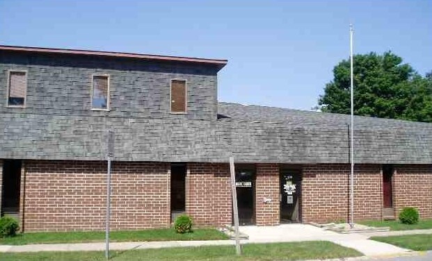
Property Record
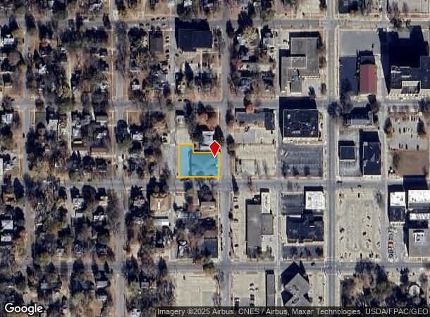
202 N Adams Ave, Mason City, IA 50401
NEARBY LISTINGS FOR SALE OR LEASE
Property Detail
202 N Adams Ave
Mason City, IA
Paul Felts Plat
07-09-229-01-300
L 8 & L 5 EXC E 108' N 34' L 5 & EXC W 57' N 4' L 5 BLK 5 PAUL FELTS PLAT
Officebuilding
Cerro Gordo
X
Iowa
19033C0164E
5
2024
0.40 AC
2025
Iowa Northeast Area
950300
Other Market Areas
11,200 SF
DEMOGRAPHICS near 202 N Adams Ave
1 Mile
3 Mile
5 Mile
2024 Total Population
10,025
25,824
26,614
2029 Population
9,794
25,071
25,833
Pop Growth 2024-2029
(2.30%)
(2.92%)
(2.93%)
Average Age
42
43
43
2024 Total Households
4,512
11,582
11,896
HH Growth 2024-2029
(2.33%)
(3.03%)
(3.05%)
Median Household Inc
$44,646
$54,976
$55,488
Avg Household Size
2.00
2.10
2.10
2024 Avg HH Vehicles
2.00
2.00
2.00
Median Home Value
$100,395
$134,667
$137,121
Median Year Built
1947
1953
1954
Nearby Places
Map Layers
Map Styles
 Street
 Aerial
- Restaurants
- Banks
- Shops
- Fitness
- Groceries
Nearby Properties
Address
Land Use
TOTAL SIZE
Lot Size
Zoning
Address
Land Use
TOTAL SIZE
Lot Size
Zoning
14,472 SF
4.65 AC
Address
Land Use
TOTAL SIZE
Lot Size
Zoning
7,956 SF
35.56 AC
Address
Land Use
TOTAL SIZE
Lot Size
Zoning
3,200 SF
79.28 AC
Address
Land Use
TOTAL SIZE
Lot Size
Zoning
17,568 SF
29.83 AC
Address
Land Use
TOTAL SIZE
Lot Size
Zoning
228,756 SF
25 AC
Address
Land Use
TOTAL SIZE
Lot Size
Zoning
14,410 SF
77.03 AC
Address
Land Use
TOTAL SIZE
Lot Size
Zoning
214,003 SF
20.89 AC
Address
Land Use
TOTAL SIZE
Lot Size
Zoning
173,295 SF
16.06 AC
Address
Land Use
TOTAL SIZE
Lot Size
Zoning
109,324 SF
16.80 AC
Address
Land Use
TOTAL SIZE
Lot Size
Zoning
188,904 SF
16.76 AC
Address
Land Use
TOTAL SIZE
Lot Size
Zoning
51,438 SF
Address
Land Use
TOTAL SIZE
Lot Size
Zoning
4,450 SF
30.90 AC
Address
Land Use
TOTAL SIZE
Lot Size
Zoning
60,118 SF
2.25 AC
Address
Land Use
TOTAL SIZE
Lot Size
Zoning
51,806 SF
10 AC
Address
Land Use
TOTAL SIZE
Lot Size
Zoning
185,264 SF
16.43 AC
Address
Land Use
TOTAL SIZE
Lot Size
Zoning
50,592 SF
10.67 AC
Address
Land Use
TOTAL SIZE
Lot Size
Zoning
35,612 SF
47.34 AC
Address
Land Use
TOTAL SIZE
Lot Size
Zoning
44,744 SF
2.26 AC
Address
Land Use
TOTAL SIZE
Lot Size
Zoning
26,400 SF
118.55 AC
Address
Land Use
TOTAL SIZE
Lot Size
Zoning
111,932 SF
13.06 AC
Address
Land Use
TOTAL SIZE
Lot Size
Zoning
75,587 SF
3.42 AC
Address
Land Use
TOTAL SIZE
Lot Size
Zoning
74,985 SF
Address
Land Use
TOTAL SIZE
Lot Size
Zoning
57,718 SF
13.45 AC
Address
Land Use
TOTAL SIZE
Lot Size
Zoning
61,150 SF
36.67 AC
Address
Land Use
TOTAL SIZE
Lot Size
Zoning
2,400 SF
11.95 AC
Address
Land Use
TOTAL SIZE
Lot Size
Zoning
5,400 SF
31.68 AC
Address
Land Use
TOTAL SIZE
Lot Size
Zoning
32,964 SF
0.46 AC
Address
Land Use
TOTAL SIZE
Lot Size
Zoning
76,901 SF
15.59 AC
Address
Land Use
TOTAL SIZE
Lot Size
Zoning
57,710 SF
14.19 AC
Address
Land Use
TOTAL SIZE
Lot Size
Zoning
63,558 SF
1.10 AC
The World's #1 Commercial Real Estate Marketplace
Connect with us
© 2026 CoStar Group
The information above has been obtained from sources believed reliable. While we do not doubt its accuracy we have not verified it and make no guarantee, warranty or representation about it. It is your responsibility to independently confirm its accuracy and completeness. Any projections, opinions, assumptions, or estimates used are for example only and do not represent the current or future performance of the property. The value of this transaction to you depends on tax and other factors which should be evaluated by your tax, financial, and legal advisors. You and your advisors should conduct a careful, independent investigation of the property to determine to your satisfaction the suitability of the property for your needs.