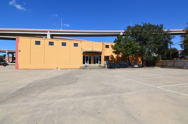
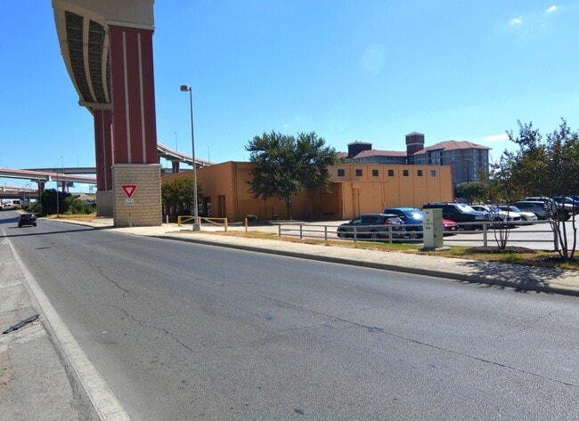
Property Record
202 Ne Loop 410, San Antonio, TX 78216

Current Lease Availabilities
Property Detail
202 Ne Loop 410
San Antonio-New Braunfels, TX
NCB 8673 BLK 6 LOT 64 EXC N IRR 38.34 FT 2018 RESURVEY PER DEED 18784/2290 EXE 10/5/2017 FILED 10/9/2017 SCG/GIS 10/27/2017
08673-006-0641
BEXAR
Miscellaneous
Texas
AE The base floodplain where base flood elevations are provided. AE Zones are now used on new format FIRMs instead of A1-A30 Zones.
641
2025
1.07 AC
2025
North Central
120701
San Antonio
20,458 SF
NEARBY LISTINGS FOR SALE OR LEASE
DEMOGRAPHICS near 202 Ne Loop 410
1 mile
3 mile
5 mile
2025 Total Population
8,012
94,760
306,996
2030 Population
8,437
99,845
322,320
Pop Growth 2025-2030
+ 5.30%
+ 5.37%
+ 4.99%
Average Age
39
40
40
2025 Total Households
3,215
40,761
131,035
HH Growth 2025-2030
+ 5.47%
+ 5.63%
+ 5.20%
Median Household Inc
$64,368
$65,484
$63,195
Avg Household Size
2.30
2.30
2.20
2025 Avg HH Vehicles
2.00
2.00
2.00
Median Home Value
$238,529
$343,896
$320,197
Median Year Built
1961
1970
1975
Nearby Places
Map Layers
Map Styles
 Street
 Aerial
Layers
 Traffic
 Biking
Places
Listings with unknown addresses are not visible on the map
- Restaurants
- Banks
- Shops
- Fitness
- Groceries
PUBLIC TRANSPORTATION
COMMUTER RAIL
San Antonio Amtrak Station (Sunset Limited - Amtrak, Texas Eagle - Amtrak)
Drive
Walk
Distance
San Antonio Amtrak Station (Sunset Limited - Amtrak, Texas Eagle - Amtrak)
11 min
8.1 mi
AIRPORT
San Antonio International
Drive
Walk
Distance
San Antonio International
2 min
0.7 mi
Freight Ports
Calhoun Port
Drive
Walk
Distance
Calhoun Port
186 min
153.5 mi
Nearby Properties
Address
Land Use
TOTAL SIZE
Lot Size
Zoning
Address
Land Use
TOTAL SIZE
Lot Size
Zoning
557,078 SF
10.73 AC
Address
Land Use
TOTAL SIZE
Lot Size
Zoning
632,091 SF
27.82 AC
Address
Land Use
TOTAL SIZE
Lot Size
Zoning
338,255 SF
29.62 AC
Address
Land Use
TOTAL SIZE
Lot Size
Zoning
324,360 SF
15.05 AC
Address
Land Use
TOTAL SIZE
Lot Size
Zoning
246,000 SF
22.54 AC
Address
Land Use
TOTAL SIZE
Lot Size
Zoning
46,451 SF
7.03 AC
Address
Land Use
TOTAL SIZE
Lot Size
Zoning
641,471 SF
41.71 AC
Address
Land Use
TOTAL SIZE
Lot Size
Zoning
317,537 SF
25.06 AC
Address
Land Use
TOTAL SIZE
Lot Size
Zoning
56,042 SF
14.60 AC
Address
Land Use
TOTAL SIZE
Lot Size
Zoning
316,556 SF
6.56 AC
Address
Land Use
TOTAL SIZE
Lot Size
Zoning
262,515 SF
6.38 AC
Address
Land Use
TOTAL SIZE
Lot Size
Zoning
506,058 SF
25.23 AC
Address
Land Use
TOTAL SIZE
Lot Size
Zoning
250,990 SF
4.89 AC
Address
Land Use
TOTAL SIZE
Lot Size
Zoning
23,738 SF
4.84 AC
Address
Land Use
TOTAL SIZE
Lot Size
Zoning
152,676 SF
13.74 AC
Address
Land Use
TOTAL SIZE
Lot Size
Zoning
33,045 SF
23.63 AC
Address
Land Use
TOTAL SIZE
Lot Size
Zoning
314,264 SF
4.27 AC
Address
Land Use
TOTAL SIZE
Lot Size
Zoning
219,400 SF
6.16 AC
Address
Land Use
TOTAL SIZE
Lot Size
Zoning
307,193 SF
7.18 AC
Address
Land Use
TOTAL SIZE
Lot Size
Zoning
360,836 SF
16.87 AC
Address
Land Use
TOTAL SIZE
Lot Size
Zoning
245,160 SF
15.10 AC
Address
Land Use
TOTAL SIZE
Lot Size
Zoning
392,678 SF
21.04 AC
Address
Land Use
TOTAL SIZE
Lot Size
Zoning
248,547 SF
3.30 AC
Address
Land Use
TOTAL SIZE
Lot Size
Zoning
74,510 SF
6.58 AC
Address
Land Use
TOTAL SIZE
Lot Size
Zoning
272,273 SF
13.62 AC
Address
Land Use
TOTAL SIZE
Lot Size
Zoning
248,413 SF
3.23 AC
Address
Land Use
TOTAL SIZE
Lot Size
Zoning
192,175 SF
5.08 AC
Address
Land Use
TOTAL SIZE
Lot Size
Zoning
308,299 SF
14.55 AC
Address
Land Use
TOTAL SIZE
Lot Size
Zoning
58,461 SF
3.60 AC
Address
Land Use
TOTAL SIZE
Lot Size
Zoning
207,297 SF
4.32 AC
The World's #1 Commercial Real Estate Marketplace
Connect with us
© 2026 CoStar Group
The information above has been obtained from sources believed reliable. While we do not doubt its accuracy we have not verified it and make no guarantee, warranty or representation about it. It is your responsibility to independently confirm its accuracy and completeness. Any projections, opinions, assumptions, or estimates used are for example only and do not represent the current or future performance of the property. The value of this transaction to you depends on tax and other factors which should be evaluated by your tax, financial, and legal advisors. You and your advisors should conduct a careful, independent investigation of the property to determine to your satisfaction the suitability of the property for your needs.