Property Record
202 Stinson Dr, Danville, VA 24540


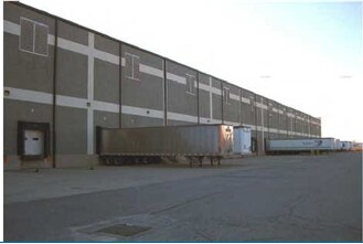
Property Detail
202 Stinson Dr
77873
C 75.142 AC NO 3D8 STINSON DR
Heavyindustrial
Danville City
LIGHT ECON
Virginia
B and X Area of moderate flood hazard, usually the area between the limits of the 100-year and 500-year floods.
75.14 AC
2025
Virginia South Central
2025
Other Market Areas
980100
Danville, VA
1,440 SF
NEARBY LISTINGS FOR SALE OR LEASE
DEMOGRAPHICS near 202 Stinson Dr
1 mile
3 mile
5 mile
2025 Total Population
242
15,818
38,896
2030 Population
234
16,043
38,742
Pop Growth 2025-2030
(3.31%)
+ 1.42%
(0.40%)
Average Age
43
42
43
2025 Total Households
115
7,183
17,311
HH Growth 2025-2030
(3.48%)
+ 1.49%
(0.42%)
Median Household Inc
$34,604
$37,949
$41,391
Avg Household Size
2.10
2.10
2.10
2025 Avg HH Vehicles
2.00
1.00
2.00
Median Home Value
$65,277
$87,507
$112,668
Median Year Built
1970
1958
1961
Nearby Places
Map Layers
Map Styles
 Street
 Aerial
Layers
 Traffic
 Biking
Places
Listings with unknown addresses are not visible on the map
- Restaurants
- Banks
- Shops
- Fitness
- Groceries
PUBLIC TRANSPORTATION
COMMUTER RAIL
Danville Amtrak Station (Crescent - Amtrak)
Drive
Walk
Distance
Danville Amtrak Station (Crescent - Amtrak)
6 min
2.8 mi
Freight Ports
Virginia Port Authority - Richmond
Drive
Walk
Distance
Virginia Port Authority - Richmond
186 min
140.7 mi
Nearby Properties
Address
Land Use
TOTAL SIZE
Lot Size
Zoning
Address
Land Use
TOTAL SIZE
Lot Size
Zoning
10,373 SF
9.49 AC
TRANSITION
Address
Land Use
TOTAL SIZE
Lot Size
Zoning
213 SF
406.98 AC
MANUFACTUR
Address
Land Use
TOTAL SIZE
Lot Size
Zoning
87.04 AC
M-1
Address
Land Use
TOTAL SIZE
Lot Size
Zoning
508,832 SF
10.86 AC
TOBACCO WA
Address
Land Use
TOTAL SIZE
Lot Size
Zoning
54,169 SF
3.44 AC
CENTRAL BU
Address
Land Use
TOTAL SIZE
Lot Size
Zoning
157,977 SF
15.99 AC
TRANSITION
Address
Land Use
TOTAL SIZE
Lot Size
Zoning
485,973 SF
135.71 AC
MANUFACTUR
Address
Land Use
TOTAL SIZE
Lot Size
Zoning
66,846 SF
22.99 AC
CYBER PARK
Address
Land Use
TOTAL SIZE
Lot Size
Zoning
23.30 AC
M-1
Address
Land Use
TOTAL SIZE
Lot Size
Zoning
48,285 SF
3.76 AC
TOBACCO WA
Address
Land Use
TOTAL SIZE
Lot Size
Zoning
7,554 SF
961.50 AC
LIGHT ECON
Address
Land Use
TOTAL SIZE
Lot Size
Zoning
2,421 SF
14.29 AC
LIGHT ECON
Address
Land Use
TOTAL SIZE
Lot Size
Zoning
833,039 SF
66.18 AC
MANUFACTUR
Address
Land Use
TOTAL SIZE
Lot Size
Zoning
205,652 SF
7.13 AC
LIGHT ECON
Address
Land Use
TOTAL SIZE
Lot Size
Zoning
312,528 SF
23.32 AC
M-1
Address
Land Use
TOTAL SIZE
Lot Size
Zoning
93,442 SF
11.94 AC
CYBER PARK
Address
Land Use
TOTAL SIZE
Lot Size
Zoning
66,954 SF
17.70 AC
TOBACCO WA
Address
Land Use
TOTAL SIZE
Lot Size
Zoning
420 SF
40.78 AC
LIGHT ECON
Address
Land Use
TOTAL SIZE
Lot Size
Zoning
33,748 SF
3.73 AC
TOBACCO WA
Address
Land Use
TOTAL SIZE
Lot Size
Zoning
6,664 SF
102.20 AC
MANUFACTUR
Address
Land Use
TOTAL SIZE
Lot Size
Zoning
162 SF
87 AC
HIGHWAY RE
Address
Land Use
TOTAL SIZE
Lot Size
Zoning
81,326 SF
1.03 AC
TRANSITION
Address
Land Use
TOTAL SIZE
Lot Size
Zoning
43,352 SF
5.59 AC
TRANSITION
Address
Land Use
TOTAL SIZE
Lot Size
Zoning
25.05 AC
M-2
Address
Land Use
TOTAL SIZE
Lot Size
Zoning
912 SF
16.33 AC
TRANSITION
Address
Land Use
TOTAL SIZE
Lot Size
Zoning
77,004 SF
22.58 AC
THRESHOLD
Address
Land Use
TOTAL SIZE
Lot Size
Zoning
37,213 SF
0.35 AC
CENTRAL BU
Address
Land Use
TOTAL SIZE
Lot Size
Zoning
149,292 SF
0.60 AC
TOBACCO WA
The World's #1 Commercial Real Estate Marketplace
Connect with us
© 2026 CoStar Group
The information above has been obtained from sources believed reliable. While we do not doubt its accuracy we have not verified it and make no guarantee, warranty or representation about it. It is your responsibility to independently confirm its accuracy and completeness. Any projections, opinions, assumptions, or estimates used are for example only and do not represent the current or future performance of the property. The value of this transaction to you depends on tax and other factors which should be evaluated by your tax, financial, and legal advisors. You and your advisors should conduct a careful, independent investigation of the property to determine to your satisfaction the suitability of the property for your needs.