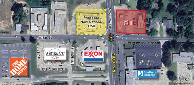
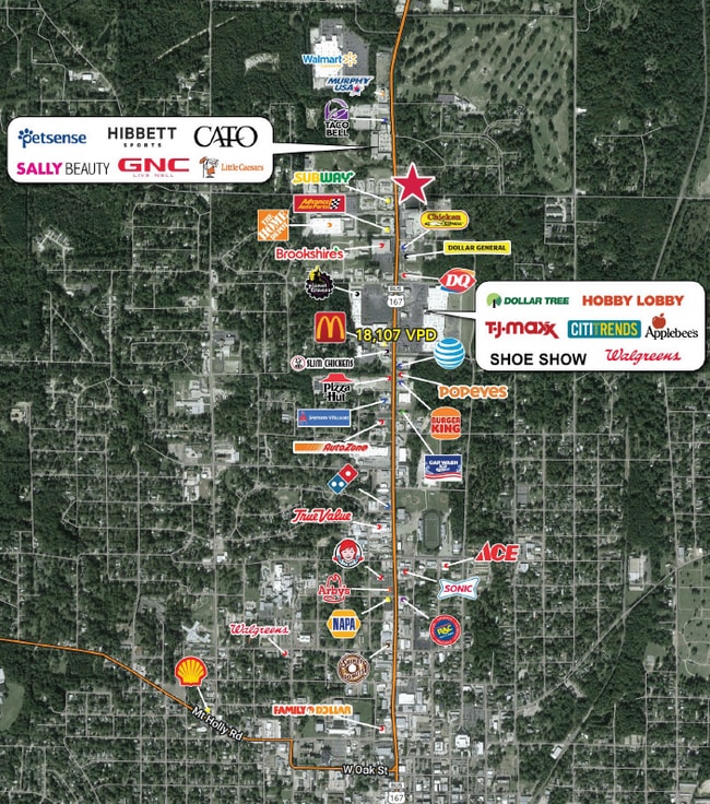
Property Record
202 W 19Th St, El Dorado, AR 71730
NEARBY LISTINGS FOR SALE OR LEASE
Property Detail
202 W 19Th St
El Dorado, AR
Country Club Colony
0680-00066-000
COUNTRY CLUB COLONY N 4' LOT 29 LESS 60X140' IN SW COR LOT 30 #12R010900 #12R010901 97 #24R003133
Officebuilding
Union
X
Arkansas
05139C0310C
29,30
2025
0.50 AC
2025
Arkansas South Area
950600
Other Market Areas
2,597 SF
DEMOGRAPHICS near 202 W 19Th St
1 Mile
3 Mile
5 Mile
2024 Total Population
3,678
17,723
22,630
2029 Population
3,540
17,338
22,030
Pop Growth 2024-2029
(3.75%)
(2.17%)
(2.65%)
Average Age
39
39
40
2024 Total Households
1,610
7,404
9,361
HH Growth 2024-2029
(3.42%)
(1.86%)
(2.33%)
Median Household Inc
$59,825
$38,223
$40,312
Avg Household Size
2.20
2.30
2.30
2024 Avg HH Vehicles
2.00
2.00
2.00
Median Home Value
$142,199
$106,244
$107,828
Median Year Built
1969
1969
1969
Nearby Places
- Restaurants
- Banks
- Shops
- Fitness
- Groceries
SALE & LEASE HISTORY
LISTING DATE
SALE/LEASE

Feb 16, 2024
For Lease
Nearby Properties
Address
Land Use
TOTAL SIZE
Lot Size
Zoning
Address
Land Use
TOTAL SIZE
Lot Size
Zoning
Address
Land Use
TOTAL SIZE
Lot Size
Zoning
Address
Land Use
TOTAL SIZE
Lot Size
Zoning
80,620 SF
4.28 AC
Address
Land Use
TOTAL SIZE
Lot Size
Zoning
85,156 SF
0.83 AC
Address
Land Use
TOTAL SIZE
Lot Size
Zoning
119,923 SF
2.89 AC
Address
Land Use
TOTAL SIZE
Lot Size
Zoning
210,108 SF
31.27 AC
Address
Land Use
TOTAL SIZE
Lot Size
Zoning
25,058 SF
2.06 AC
Address
Land Use
TOTAL SIZE
Lot Size
Zoning
68,861 SF
0.99 AC
Address
Land Use
TOTAL SIZE
Lot Size
Zoning
54,204 SF
6.39 AC
Address
Land Use
TOTAL SIZE
Lot Size
Zoning
44,772 SF
0.38 AC
Address
Land Use
TOTAL SIZE
Lot Size
Zoning
24,398 SF
22 AC
Address
Land Use
TOTAL SIZE
Lot Size
Zoning
44,300 SF
0.92 AC
Address
Land Use
TOTAL SIZE
Lot Size
Zoning
4,496 SF
18.83 AC
Address
Land Use
TOTAL SIZE
Lot Size
Zoning
44,374 SF
1.98 AC
Address
Land Use
TOTAL SIZE
Lot Size
Zoning
105,379 SF
13.61 AC
Address
Land Use
TOTAL SIZE
Lot Size
Zoning
106,502 SF
14.34 AC
Address
Land Use
TOTAL SIZE
Lot Size
Zoning
2,478 SF
5.79 AC
Address
Land Use
TOTAL SIZE
Lot Size
Zoning
12,972 SF
Address
Land Use
TOTAL SIZE
Lot Size
Zoning
61,612 SF
3.40 AC
Address
Land Use
TOTAL SIZE
Lot Size
Zoning
180,463 SF
16.35 AC
Address
Land Use
TOTAL SIZE
Lot Size
Zoning
42,993 SF
2.75 AC
Address
Land Use
TOTAL SIZE
Lot Size
Zoning
58,189 SF
0.23 AC
Address
Land Use
TOTAL SIZE
Lot Size
Zoning
14,220 SF
3.33 AC
Address
Land Use
TOTAL SIZE
Lot Size
Zoning
9,936 SF
10.86 AC
Address
Land Use
TOTAL SIZE
Lot Size
Zoning
9,376 SF
5.40 AC
Address
Land Use
TOTAL SIZE
Lot Size
Zoning
37,274 SF
4.73 AC
Address
Land Use
TOTAL SIZE
Lot Size
Zoning
65,074 SF
0.71 AC
Address
Land Use
TOTAL SIZE
Lot Size
Zoning
28,024 SF
12.50 AC
Address
Land Use
TOTAL SIZE
Lot Size
Zoning
2,312 SF
4.97 AC
Address
Land Use
TOTAL SIZE
Lot Size
Zoning
48,550 SF
1.09 AC
The World's #1 Commercial Real Estate Marketplace
Connect with us
© 2025 CoStar Group
The information above has been obtained from sources believed reliable. While we do not doubt its accuracy we have not verified it and make no guarantee, warranty or representation about it. It is your responsibility to independently confirm its accuracy and completeness. Any projections, opinions, assumptions, or estimates used are for example only and do not represent the current or future performance of the property. The value of this transaction to you depends on tax and other factors which should be evaluated by your tax, financial, and legal advisors. You and your advisors should conduct a careful, independent investigation of the property to determine to your satisfaction the suitability of the property for your needs.