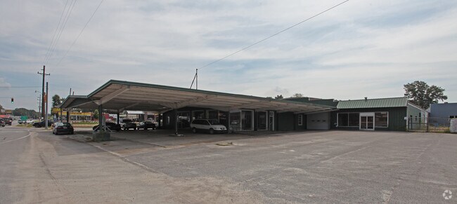
Property Record
202 W Church St, Batesburg, SC 29006


NEARBY LISTINGS FOR SALE OR LEASE
Property Detail
202 W Church St
Autorepair
Lexington
X
South Carolina
45063C0195J
1.80 AC
2025
Outlying Lexington County
2024
Columbia
021402
Columbia, SC
20,659 SF
005918-04-010
DEMOGRAPHICS near 202 W Church St
1 Mile
3 Mile
5 Mile
2024 Total Population
2,087
7,509
10,817
2029 Population
2,306
8,176
11,746
Pop Growth 2024-2029
+ 10.49%
+ 8.88%
+ 8.59%
Average Age
42
42
42
2024 Total Households
862
3,066
4,373
HH Growth 2024-2029
+ 10.79%
+ 9.10%
+ 8.78%
Median Household Inc
$42,574
$46,688
$47,999
Avg Household Size
2.30
2.40
2.40
2024 Avg HH Vehicles
2.00
2.00
2.00
Median Home Value
$166,421
$174,314
$171,648
Median Year Built
1968
1973
1977
Nearby Places
Map Layers
Map Styles
 Street
 Aerial
- Restaurants
- Banks
- Shops
- Fitness
- Groceries
PUBLIC TRANSPORTATION
AIRPORT
Columbia Metro
DRIVE
WALK
Distance
Columbia Metro
57 min
30.6 mi
Freight Ports
North Charleston Terminal
DRIVE
WALK
Distance
North Charleston Terminal
158 min
128.4 mi
SALE & LEASE HISTORY
LISTING DATE
SALE/LEASE

Sep 24, 2016
For Sale
Nov 22, 2022
For Sale
Nearby Properties
Address
Land Use
TOTAL SIZE
Lot Size
Zoning
Address
Land Use
TOTAL SIZE
Lot Size
Zoning
204,496 SF
23.59 AC
Address
Land Use
TOTAL SIZE
Lot Size
Zoning
7,500 SF
9.40 AC
Address
Land Use
TOTAL SIZE
Lot Size
Zoning
Address
Land Use
TOTAL SIZE
Lot Size
Zoning
38,320 SF
5.87 AC
RD
Address
Land Use
TOTAL SIZE
Lot Size
Zoning
4,559 SF
2.90 AC
Address
Land Use
TOTAL SIZE
Lot Size
Zoning
13,894 SF
1.43 AC
Address
Land Use
TOTAL SIZE
Lot Size
Zoning
115.60 AC
Address
Land Use
TOTAL SIZE
Lot Size
Zoning
1,968 SF
2.50 AC
Address
Land Use
TOTAL SIZE
Lot Size
Zoning
1,512 SF
2.10 AC
Address
Land Use
TOTAL SIZE
Lot Size
Zoning
2,106 SF
4.80 AC
Address
Land Use
TOTAL SIZE
Lot Size
Zoning
2,436 SF
5 AC
Address
Land Use
TOTAL SIZE
Lot Size
Zoning
5,100 SF
1.58 AC
RD
Address
Land Use
TOTAL SIZE
Lot Size
Zoning
20,100 SF
3.92 AC
Address
Land Use
TOTAL SIZE
Lot Size
Zoning
45,649 SF
6.17 AC
ID
Address
Land Use
TOTAL SIZE
Lot Size
Zoning
25,056 SF
5.88 AC
RD
Address
Land Use
TOTAL SIZE
Lot Size
Zoning
50,350 SF
6.32 AC
C1
Address
Land Use
TOTAL SIZE
Lot Size
Zoning
3,142 SF
1.12 AC
RD
Address
Land Use
TOTAL SIZE
Lot Size
Zoning
15,794 SF
4.45 AC
LR
Address
Land Use
TOTAL SIZE
Lot Size
Zoning
6,214 SF
7.39 AC
R
Address
Land Use
TOTAL SIZE
Lot Size
Zoning
11,831 SF
1.27 AC
RD
Address
Land Use
TOTAL SIZE
Lot Size
Zoning
Address
Land Use
TOTAL SIZE
Lot Size
Zoning
1,227 SF
7 AC
C1
Address
Land Use
TOTAL SIZE
Lot Size
Zoning
2,226 SF
0.61 AC
Address
Land Use
TOTAL SIZE
Lot Size
Zoning
55,682 SF
6.34 AC
C1
Address
Land Use
TOTAL SIZE
Lot Size
Zoning
15,673 SF
2.65 AC
C2
Address
Land Use
TOTAL SIZE
Lot Size
Zoning
4,437 SF
13.94 AC
RD
Address
Land Use
TOTAL SIZE
Lot Size
Zoning
3,488 SF
0.81 AC
Address
Land Use
TOTAL SIZE
Lot Size
Zoning
33.80 AC
Address
Land Use
TOTAL SIZE
Lot Size
Zoning
1,568 SF
0.75 AC
Address
Land Use
TOTAL SIZE
Lot Size
Zoning
3,000 SF
0.72 AC
RD
The World's #1 Commercial Real Estate Marketplace
Connect with us
© 2026 CoStar Group
The information above has been obtained from sources believed reliable. While we do not doubt its accuracy we have not verified it and make no guarantee, warranty or representation about it. It is your responsibility to independently confirm its accuracy and completeness. Any projections, opinions, assumptions, or estimates used are for example only and do not represent the current or future performance of the property. The value of this transaction to you depends on tax and other factors which should be evaluated by your tax, financial, and legal advisors. You and your advisors should conduct a careful, independent investigation of the property to determine to your satisfaction the suitability of the property for your needs.