Property Record
202 W Glenlord Rd, Saint Joseph, MI 49085
NEARBY LISTINGS FOR SALE OR LEASE
Property Detail
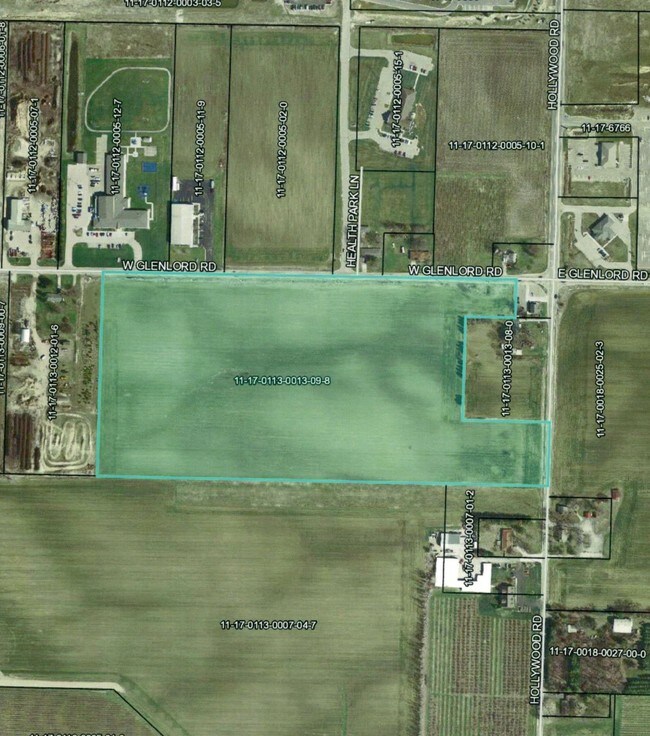
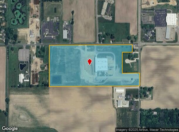
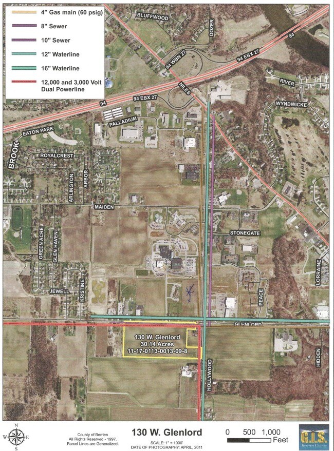
202 W Glenlord Rd
11-17-0113-0013-09-8
COM AT THE NE COR SEC 13 T5S R19W TH W 148.5' TO POB TH S 156.75' TH W 198' TH N 156.75' TH E 198' TO POB ALSO COM 346.5' S89DEG26'19W OF NE COR SEC 13 T5S R19W TH S00DEG01'12"E 825' TH S89DEG26'19"W 1447.92' TH N00DEG00'23"E 825' TH N89DEG26'19"E 14
Agriculturalland
Berrien
X
Michigan
26021C0112C
30.14 AC
2024
Michigan Southwest Area
2025
Other Market Areas
001100
Niles-Benton Harbor, MI
DEMOGRAPHICS near 202 W Glenlord Rd
1 Mile
3 Mile
5 Mile
2024 Total Population
1,667
21,245
49,925
2029 Population
1,615
20,646
48,995
Pop Growth 2024-2029
(3.12%)
(2.82%)
(1.86%)
Average Age
45
43
42
2024 Total Households
654
8,564
20,826
HH Growth 2024-2029
(3.21%)
(2.97%)
(2.10%)
Median Household Inc
$86,422
$85,444
$64,646
Avg Household Size
2.40
2.40
2.30
2024 Avg HH Vehicles
2.00
2.00
2.00
Median Home Value
$251,463
$240,860
$224,765
Median Year Built
1976
1970
1966
Nearby Places
Map Layers
Map Styles
 Street
 Aerial
- Restaurants
- Banks
- Shops
- Fitness
- Groceries
PUBLIC TRANSPORTATION
COMMUTER RAIL
St. Joseph-Benton Harbor Amtrak Station (Pere Marquette - Amtrak)
DRIVE
WALK
Distance
St. Joseph-Benton Harbor Amtrak Station (Pere Marquette - Amtrak)
14 min
6.1 mi
AIRPORT
South Bend International
DRIVE
WALK
Distance
South Bend International
46 min
30.3 mi
Freight Ports
Port Milwaukee
DRIVE
WALK
Distance
Port Milwaukee
218 min
179.1 mi
SALE & LEASE HISTORY
LISTING DATE
SALE/LEASE

Oct 31, 2016
For Sale
Nearby Properties
Address
Land Use
TOTAL SIZE
Lot Size
Zoning
Address
Land Use
TOTAL SIZE
Lot Size
Zoning
200,321 SF
15.47 AC
D1 COMM
Address
Land Use
TOTAL SIZE
Lot Size
Zoning
87,978 SF
4.36 AC
R2 MDR
Address
Land Use
TOTAL SIZE
Lot Size
Zoning
69,180 SF
3.58 AC
D1 COMM
Address
Land Use
TOTAL SIZE
Lot Size
Zoning
73,505 SF
4.02 AC
D1 COMM
Address
Land Use
TOTAL SIZE
Lot Size
Zoning
66,680 SF
3.42 AC
Address
Land Use
TOTAL SIZE
Lot Size
Zoning
53,504 SF
Address
Land Use
TOTAL SIZE
Lot Size
Zoning
61,732 SF
3.51 AC
D1 COMM
Address
Land Use
TOTAL SIZE
Lot Size
Zoning
42,610 SF
5.30 AC
C4 HEAVY
Address
Land Use
TOTAL SIZE
Lot Size
Zoning
330,000 SF
20.56 AC
I1
Address
Land Use
TOTAL SIZE
Lot Size
Zoning
45,270 SF
10.30 AC
C1 GEN COM
Address
Land Use
TOTAL SIZE
Lot Size
Zoning
49,527 SF
4.47 AC
PUD
Address
Land Use
TOTAL SIZE
Lot Size
Zoning
103,591 SF
8.77 AC
D1 COMM
Address
Land Use
TOTAL SIZE
Lot Size
Zoning
403,396 SF
37.17 AC
HI
Address
Land Use
TOTAL SIZE
Lot Size
Zoning
172,489 SF
12.66 AC
E RESTRICT
Address
Land Use
TOTAL SIZE
Lot Size
Zoning
54,750 SF
5.87 AC
CMU
Address
Land Use
TOTAL SIZE
Lot Size
Zoning
9,136 SF
79.96 AC
MH
Address
Land Use
TOTAL SIZE
Lot Size
Zoning
62,721 SF
16.85 AC
CMU
Address
Land Use
TOTAL SIZE
Lot Size
Zoning
23,234 SF
3.94 AC
PUD
Address
Land Use
TOTAL SIZE
Lot Size
Zoning
46,584 SF
12.19 AC
D1 COMM
Address
Land Use
TOTAL SIZE
Lot Size
Zoning
29,032 SF
4.62 AC
C1 GEN COM
Address
Land Use
TOTAL SIZE
Lot Size
Zoning
30,497 SF
6.68 AC
D1 COMM
Address
Land Use
TOTAL SIZE
Lot Size
Zoning
36,912 SF
30.54 AC
E RESTRICT
Address
Land Use
TOTAL SIZE
Lot Size
Zoning
121,500 SF
16.54 AC
I1
Address
Land Use
TOTAL SIZE
Lot Size
Zoning
33,550 SF
1.94 AC
C1 GEN COM
Address
Land Use
TOTAL SIZE
Lot Size
Zoning
128,076 SF
29.98 AC
LD
Address
Land Use
TOTAL SIZE
Lot Size
Zoning
28,344 SF
4.62 AC
C1 GEN COM
Address
Land Use
TOTAL SIZE
Lot Size
Zoning
Address
Land Use
TOTAL SIZE
Lot Size
Zoning
40,758 SF
9.20 AC
Address
Land Use
TOTAL SIZE
Lot Size
Zoning
25,029 SF
4.22 AC
B2 - RET/S
Address
Land Use
TOTAL SIZE
Lot Size
Zoning
33,625 SF
5.09 AC
D1 COMM
The World's #1 Commercial Real Estate Marketplace
Connect with us
© 2025 CoStar Group
The information above has been obtained from sources believed reliable. While we do not doubt its accuracy we have not verified it and make no guarantee, warranty or representation about it. It is your responsibility to independently confirm its accuracy and completeness. Any projections, opinions, assumptions, or estimates used are for example only and do not represent the current or future performance of the property. The value of this transaction to you depends on tax and other factors which should be evaluated by your tax, financial, and legal advisors. You and your advisors should conduct a careful, independent investigation of the property to determine to your satisfaction the suitability of the property for your needs.