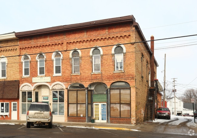
Property Record
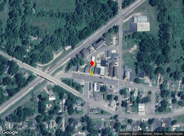
202 W Main St, Parma, MI 49269
NEARBY LISTINGS FOR SALE OR LEASE
Property Detail
202 W Main St
006-06-36-228-008-00
SEC 36 T2SR3W VILLAGE OF PARMA PART NE1/4 COM 1109.86 FT S & 33 FT W & N80?34'W 249.66 FT FROM NE COR SEC N09?26'E 125 FT
Retailwithmorethanonenonretailuse
Jackson
X
Michigan
26075C0175D
0.07 AC
2024
Jackson County
2025
West Michigan
006500
Jackson, MI
4,170 SF
DEMOGRAPHICS near 202 W Main St
1 mile
3 mile
5 mile
2024 Total Population
938
2,759
10,582
2029 Population
928
2,723
10,483
Pop Growth 2024-2029
(1.07%)
(1.30%)
(0.94%)
Average Age
39
41
39
2024 Total Households
343
1,025
3,619
HH Growth 2024-2029
(1.17%)
(1.46%)
(1.13%)
Median Household Inc
$74,594
$72,721
$66,813
Avg Household Size
2.70
2.60
2.50
2024 Avg HH Vehicles
2.00
2.00
2.00
Median Home Value
$186,324
$179,327
$174,330
Median Year Built
1972
1972
1976
Nearby Places
Map Layers
Map Styles
 Street
 Aerial
Transit
 Traffic
 Biking
Places
Listings with unknown addresses are not visible on the map
- Restaurants
- Banks
- Shops
- Fitness
- Groceries
PUBLIC TRANSPORTATION
COMMUTER RAIL
Drive
Walk
Distance
14 min
9.2 mi
SALE & LEASE HISTORY
LISTING DATE
SALE/LEASE

Jan 15, 2025
For Sale
Nearby Properties
Address
Land Use
TOTAL SIZE
Lot Size
Zoning
Address
Land Use
TOTAL SIZE
Lot Size
Zoning
994,960 SF
93.25 AC
C-2 GEN
Address
Land Use
TOTAL SIZE
Lot Size
Zoning
27,800 SF
3.27 AC
L.I-1
Address
Land Use
TOTAL SIZE
Lot Size
Zoning
8,680 SF
10.92 AC
C 2
Address
Land Use
TOTAL SIZE
Lot Size
Zoning
138 AC
AG 1
Address
Land Use
TOTAL SIZE
Lot Size
Zoning
6,258 SF
40 AC
AG 1
Address
Land Use
TOTAL SIZE
Lot Size
Zoning
7,488 SF
73.30 AC
AG-1
Address
Land Use
TOTAL SIZE
Lot Size
Zoning
119.70 AC
AG 1
Address
Land Use
TOTAL SIZE
Lot Size
Zoning
115.43 AC
AG 1
Address
Land Use
TOTAL SIZE
Lot Size
Zoning
12,078 SF
15.44 AC
C 2
Address
Land Use
TOTAL SIZE
Lot Size
Zoning
113 AC
AG 1
Address
Land Use
TOTAL SIZE
Lot Size
Zoning
5 AC
AG
Address
Land Use
TOTAL SIZE
Lot Size
Zoning
18.90 AC
AG 1
Address
Land Use
TOTAL SIZE
Lot Size
Zoning
5,700 SF
40.01 AC
AG 1
Address
Land Use
TOTAL SIZE
Lot Size
Zoning
2,553 SF
20 AC
AG-1
Address
Land Use
TOTAL SIZE
Lot Size
Zoning
3,164 SF
140.22 AC
AG-1
Address
Land Use
TOTAL SIZE
Lot Size
Zoning
1,960 SF
193.50 AC
AG
Address
Land Use
TOTAL SIZE
Lot Size
Zoning
218.88 AC
AG 1
Address
Land Use
TOTAL SIZE
Lot Size
Zoning
85 AC
AG 1
Address
Land Use
TOTAL SIZE
Lot Size
Zoning
4,086 SF
12.07 AC
AG 1
Address
Land Use
TOTAL SIZE
Lot Size
Zoning
3,094 SF
29 AC
AG 1
Address
Land Use
TOTAL SIZE
Lot Size
Zoning
2,340 SF
140.50 AC
AG-1
Address
Land Use
TOTAL SIZE
Lot Size
Zoning
2,540 SF
173.10 AC
AG 1
Address
Land Use
TOTAL SIZE
Lot Size
Zoning
2,833 SF
11.73 AC
AG1/RS2
Address
Land Use
TOTAL SIZE
Lot Size
Zoning
2,044 SF
157 AC
AG 1
Address
Land Use
TOTAL SIZE
Lot Size
Zoning
21,000 SF
3.18 AC
L.I-1
Address
Land Use
TOTAL SIZE
Lot Size
Zoning
4,488 SF
74 AC
AG-1
Address
Land Use
TOTAL SIZE
Lot Size
Zoning
178.11 AC
AG
Address
Land Use
TOTAL SIZE
Lot Size
Zoning
157.50 AC
AG
Address
Land Use
TOTAL SIZE
Lot Size
Zoning
157.91 AC
AG
Address
Land Use
TOTAL SIZE
Lot Size
Zoning
159 AC
AG 1
The World's #1 Commercial Real Estate Marketplace
Connect with us
© 2026 CoStar Group
The information above has been obtained from sources believed reliable. While we do not doubt its accuracy we have not verified it and make no guarantee, warranty or representation about it. It is your responsibility to independently confirm its accuracy and completeness. Any projections, opinions, assumptions, or estimates used are for example only and do not represent the current or future performance of the property. The value of this transaction to you depends on tax and other factors which should be evaluated by your tax, financial, and legal advisors. You and your advisors should conduct a careful, independent investigation of the property to determine to your satisfaction the suitability of the property for your needs.