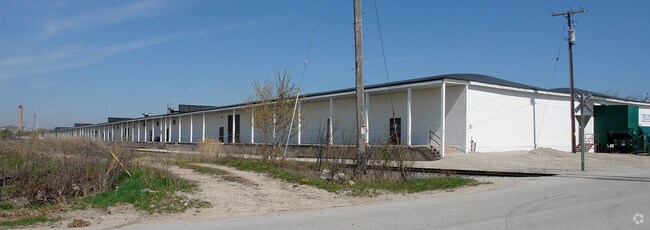
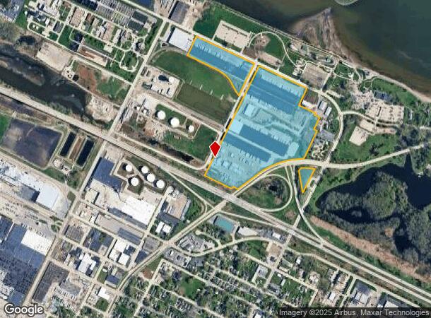
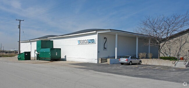
Property Record
2020 Angie Ave, Green Bay, WI 54302
NEARBY LISTINGS FOR SALE OR LEASE
Property Detail
2020 Angie Ave
20-694
Cryans Plat/Bay Beach
Commercialnec
53.923 AC M/L PRT OF PC 44 & 45 ESFR & PRT OF CRYANS PLAT OF BAY BEACH DESC IN 313 D 189 & 337 D 222 EX 76J217-19 ALSO 100 FT STRIP IN J5467-7 & EX PRT OF CRYANS PLAT OF BAY BEACH AS DESC IN J9233-7 & PRT IN 1645367 & PRT OF PC 1 ESFR DESC IN 1687722
X
Brown
55009C0188G
Wisconsin
2024
53.92 AC
2024
Green Bay
001802
Green Bay
567,424 SF
Green Bay, WI
DEMOGRAPHICS near 2020 Angie Ave
1 Mile
3 Mile
5 Mile
2024 Total Population
2,170
54,724
121,238
2029 Population
2,171
55,728
123,562
Pop Growth 2024-2029
+ 0.05%
+ 1.83%
+ 1.92%
Average Age
33
36
38
2024 Total Households
746
22,113
50,589
HH Growth 2024-2029
+ 0.13%
+ 1.93%
+ 2.01%
Median Household Inc
$46,875
$49,911
$53,776
Avg Household Size
2.60
2.30
2.30
2024 Avg HH Vehicles
2.00
2.00
2.00
Median Home Value
$87,229
$146,478
$169,079
Median Year Built
1958
1958
1970
Nearby Places
Map Layers
Map Styles
 Street
 Aerial
- Restaurants
- Banks
- Shops
- Fitness
- Groceries
PUBLIC TRANSPORTATION
AIRPORT
Green Bay/Austin Straubel International
DRIVE
WALK
Distance
Green Bay/Austin Straubel International
20 min
10.4 mi
Appleton International
DRIVE
WALK
Distance
Appleton International
54 min
40.9 mi
Nearby Properties
Address
Land Use
TOTAL SIZE
Lot Size
Zoning
Address
Land Use
TOTAL SIZE
Lot Size
Zoning
36.49 AC
Address
Land Use
TOTAL SIZE
Lot Size
Zoning
6.32 AC
R1
Address
Land Use
TOTAL SIZE
Lot Size
Zoning
3,368 SF
27.55 AC
C1, OR
Address
Land Use
TOTAL SIZE
Lot Size
Zoning
96.49 AC
Address
Land Use
TOTAL SIZE
Lot Size
Zoning
14.75 AC
Address
Land Use
TOTAL SIZE
Lot Size
Zoning
23.44 AC
Address
Land Use
TOTAL SIZE
Lot Size
Zoning
Address
Land Use
TOTAL SIZE
Lot Size
Zoning
13.56 AC
C1, R3
Address
Land Use
TOTAL SIZE
Lot Size
Zoning
0.74 AC
Address
Land Use
TOTAL SIZE
Lot Size
Zoning
15.43 AC
Address
Land Use
TOTAL SIZE
Lot Size
Zoning
44.27 AC
Address
Land Use
TOTAL SIZE
Lot Size
Zoning
0.63 AC
Address
Land Use
TOTAL SIZE
Lot Size
Zoning
1.25 AC
Address
Land Use
TOTAL SIZE
Lot Size
Zoning
28.20 AC
Address
Land Use
TOTAL SIZE
Lot Size
Zoning
25.53 AC
Address
Land Use
TOTAL SIZE
Lot Size
Zoning
0.48 AC
Address
Land Use
TOTAL SIZE
Lot Size
Zoning
81,981 SF
0.80 AC
D2
Address
Land Use
TOTAL SIZE
Lot Size
Zoning
567,424 SF
53.92 AC
C1, GI
Address
Land Use
TOTAL SIZE
Lot Size
Zoning
Address
Land Use
TOTAL SIZE
Lot Size
Zoning
320,146 SF
48.50 AC
GI, R1
Address
Land Use
TOTAL SIZE
Lot Size
Zoning
418,272 SF
31.74 AC
GI
Address
Land Use
TOTAL SIZE
Lot Size
Zoning
268,880 SF
23.35 AC
GI
Address
Land Use
TOTAL SIZE
Lot Size
Zoning
982 SF
33.26 AC
R1
Address
Land Use
TOTAL SIZE
Lot Size
Zoning
936 SF
3.09 AC
R1
Address
Land Use
TOTAL SIZE
Lot Size
Zoning
1,575 SF
33.37 AC
R1
Address
Land Use
TOTAL SIZE
Lot Size
Zoning
3.86 AC
Address
Land Use
TOTAL SIZE
Lot Size
Zoning
9.11 AC
Address
Land Use
TOTAL SIZE
Lot Size
Zoning
17.20 AC
Address
Land Use
TOTAL SIZE
Lot Size
Zoning
9.21 AC
Address
Land Use
TOTAL SIZE
Lot Size
Zoning
952 SF
12.59 AC
R3
The World's #1 Commercial Real Estate Marketplace
Connect with us
© 2026 CoStar Group
The information above has been obtained from sources believed reliable. While we do not doubt its accuracy we have not verified it and make no guarantee, warranty or representation about it. It is your responsibility to independently confirm its accuracy and completeness. Any projections, opinions, assumptions, or estimates used are for example only and do not represent the current or future performance of the property. The value of this transaction to you depends on tax and other factors which should be evaluated by your tax, financial, and legal advisors. You and your advisors should conduct a careful, independent investigation of the property to determine to your satisfaction the suitability of the property for your needs.