Property Record
2020 E Clark Rd, Ann Arbor, MI 48108
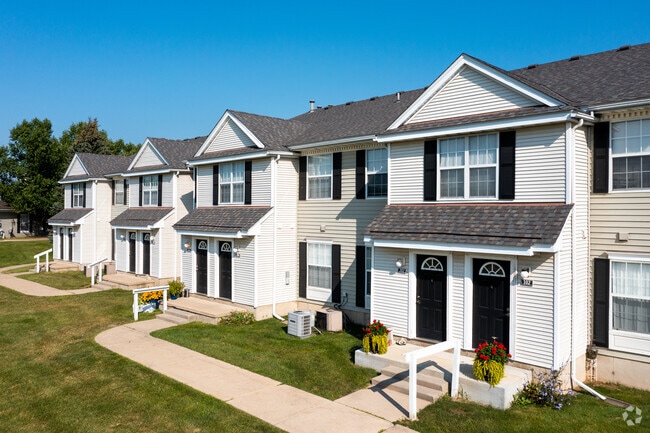

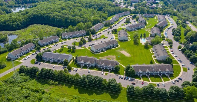
Property Detail
2020 E Clark Rd
12-01-100-036
ASSR REQUEST ****FROM 1201100008 12/26/97 ****FROM 1201100009 12/26/97 PI 1-3B-1 BEG AT N 1/4 COR SEC 1, TH N 89-00-16 E
Apartment
WASHTENAW
B and X Area of moderate flood hazard, usually the area between the limits of the 100-year and 500-year floods.
Michigan
2025
37.87 AC
2025
Ypsilanti
405600
Detroit
13,720 SF
Ann Arbor, MI
NEARBY LISTINGS FOR SALE OR LEASE
-
-
View all Ann Arbor listings for sale on LoopNet.com
DEMOGRAPHICS near 2020 E Clark Rd
1 mile
3 mile
5 mile
2025 Total Population
9,535
77,109
200,219
2030 Population
9,465
80,244
206,741
Pop Growth 2025-2030
(0.73%)
+ 4.07%
+ 3.26%
Average Age
35
37
36
2025 Total Households
4,746
33,461
82,852
HH Growth 2025-2030
(0.91%)
+ 4.04%
+ 3.37%
Median Household Inc
$53,672
$64,020
$69,456
Avg Household Size
1.90
2.10
2.20
2025 Avg HH Vehicles
1.00
2.00
2.00
Median Home Value
$306,308
$336,586
$349,714
Median Year Built
1976
1977
1977
Nearby Places
Map Layers
Map Styles
 Street
 Aerial
Layers
 Traffic
 Biking
Places
Listings with unknown addresses are not visible on the map
- Restaurants
- Banks
- Shops
- Fitness
- Groceries
PUBLIC TRANSPORTATION
COMMUTER RAIL
Ann Arbor Amtrak Station (Wolverine - Amtrak)
Drive
Walk
Distance
Ann Arbor Amtrak Station (Wolverine - Amtrak)
12 min
5.6 mi
AIRPORT
Detroit Metro Wayne County
Drive
Walk
Distance
Detroit Metro Wayne County
30 min
21.2 mi
Freight Ports
Port of Toledo
Drive
Walk
Distance
Port of Toledo
73 min
57.0 mi
Nearby Properties
Address
Land Use
TOTAL SIZE
Lot Size
Zoning
Address
Land Use
TOTAL SIZE
Lot Size
Zoning
407,374 SF
35.17 AC
C3
Address
Land Use
TOTAL SIZE
Lot Size
Zoning
2,668 SF
31.60 AC
PUD
Address
Land Use
TOTAL SIZE
Lot Size
Zoning
315,108 SF
6.57 AC
C1B
Address
Land Use
TOTAL SIZE
Lot Size
Zoning
169,963 SF
86.24 AC
P-M
Address
Land Use
TOTAL SIZE
Lot Size
Zoning
36,000 SF
27.61 AC
BI
Address
Land Use
TOTAL SIZE
Lot Size
Zoning
37,500 SF
25.94 AC
BI
Address
Land Use
TOTAL SIZE
Lot Size
Zoning
273,440 SF
73.06 AC
RRA
Address
Land Use
TOTAL SIZE
Lot Size
Zoning
208,890 SF
A-1
Address
Land Use
TOTAL SIZE
Lot Size
Zoning
118,166 SF
P-M
Address
Land Use
TOTAL SIZE
Lot Size
Zoning
17,672 SF
33.37 AC
BI
Address
Land Use
TOTAL SIZE
Lot Size
Zoning
361,634 SF
17.09 AC
Address
Land Use
TOTAL SIZE
Lot Size
Zoning
32,040 SF
22.33 AC
BI
Address
Land Use
TOTAL SIZE
Lot Size
Zoning
5,416 SF
30.14 AC
R-9
Address
Land Use
TOTAL SIZE
Lot Size
Zoning
340,425 SF
31.50 AC
R4B
Address
Land Use
TOTAL SIZE
Lot Size
Zoning
27,603 SF
35.42 AC
BI
Address
Land Use
TOTAL SIZE
Lot Size
Zoning
119,631 SF
7.85 AC
PUD
Address
Land Use
TOTAL SIZE
Lot Size
Zoning
480 SF
23.64 AC
BI
Address
Land Use
TOTAL SIZE
Lot Size
Zoning
94,157 SF
7.20 AC
C3
Address
Land Use
TOTAL SIZE
Lot Size
Zoning
192,963 SF
21.19 AC
R4A
Address
Land Use
TOTAL SIZE
Lot Size
Zoning
27,306 SF
16.08 AC
BI
Address
Land Use
TOTAL SIZE
Lot Size
Zoning
13,224 SF
24.30 AC
BI
Address
Land Use
TOTAL SIZE
Lot Size
Zoning
16,472 SF
29 AC
Address
Land Use
TOTAL SIZE
Lot Size
Zoning
110,389 SF
16.04 AC
RRA
Address
Land Use
TOTAL SIZE
Lot Size
Zoning
170,742 SF
6.73 AC
R4B
Address
Land Use
TOTAL SIZE
Lot Size
Zoning
72,465 SF
13.09 AC
R4A
Address
Land Use
TOTAL SIZE
Lot Size
Zoning
8.02 AC
R4B
Address
Land Use
TOTAL SIZE
Lot Size
Zoning
38,070 SF
21.15 AC
BI
Address
Land Use
TOTAL SIZE
Lot Size
Zoning
Address
Land Use
TOTAL SIZE
Lot Size
Zoning
18,110 SF
14.80 AC
BI
The World's #1 Commercial Real Estate Marketplace
Connect with us
© 2026 CoStar Group
The information above has been obtained from sources believed reliable. While we do not doubt its accuracy we have not verified it and make no guarantee, warranty or representation about it. It is your responsibility to independently confirm its accuracy and completeness. Any projections, opinions, assumptions, or estimates used are for example only and do not represent the current or future performance of the property. The value of this transaction to you depends on tax and other factors which should be evaluated by your tax, financial, and legal advisors. You and your advisors should conduct a careful, independent investigation of the property to determine to your satisfaction the suitability of the property for your needs.