Property Record
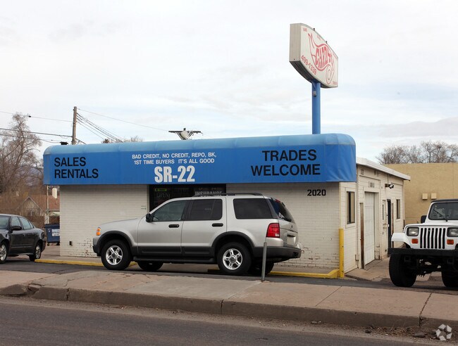
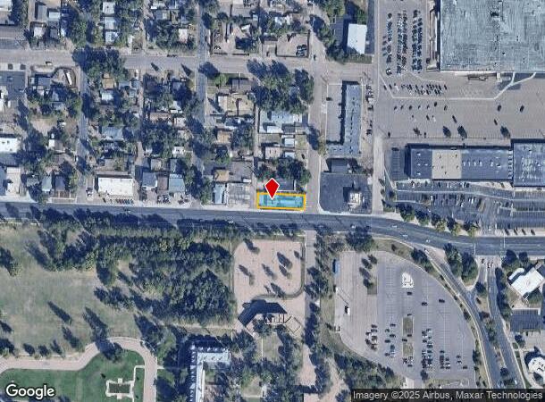
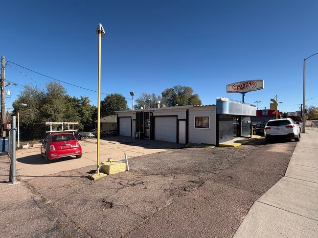
2020 E Pikes Peak Ave, Colorado Springs, CO 80909
This Property Is For Sale
NEARBY LISTINGS FOR SALE OR LEASE
Property Detail
2020 E Pikes Peak Ave
Colorado Springs, CO
Knob Hill First Add
64162-19-035
LOT 17 BLK 45 FIRST ADD TO KNOB HILL TOG WITH VAC WLY 10.0 FT OF IOWA AVE ADJ BY ORDINANCE DESC IN BK 3903-1356
Commercialnec
El Paso
X
Colorado
08041C0733G
17
2024
0.17 AC
2025
East
002101
Colorado Springs
767 SF
DEMOGRAPHICS near 2020 E Pikes Peak Ave
1 Mile
3 Mile
5 Mile
2024 Total Population
14,323
127,629
270,806
2029 Population
15,040
133,899
283,045
Pop Growth 2024-2029
+ 5.01%
+ 4.91%
+ 4.52%
Average Age
40
38
39
2024 Total Households
6,542
54,826
114,301
HH Growth 2024-2029
+ 5.23%
+ 5.15%
+ 4.80%
Median Household Inc
$49,374
$53,805
$59,427
Avg Household Size
2.10
2.20
2.30
2024 Avg HH Vehicles
1.00
2.00
2.00
Median Home Value
$308,559
$320,371
$340,855
Median Year Built
1964
1969
1976
Nearby Places
- Restaurants
- Banks
- Shops
- Fitness
- Groceries
PUBLIC TRANSPORTATION
AIRPORT
City of Colorado Springs Municipal
DRIVE
WALK
Distance
City of Colorado Springs Municipal
16 min
7.1 mi
Nearby Properties
Address
Land Use
TOTAL SIZE
Lot Size
Zoning
Address
Land Use
TOTAL SIZE
Lot Size
Zoning
1,072,186 SF
15.14 AC
MX-N HR CU
Address
Land Use
TOTAL SIZE
Lot Size
Zoning
586,419 SF
17.77 AC
R-5 CU
Address
Land Use
TOTAL SIZE
Lot Size
Zoning
604,992 SF
28.95 AC
MX-T CU
Address
Land Use
TOTAL SIZE
Lot Size
Zoning
215,464 SF
11.59 AC
R-5
Address
Land Use
TOTAL SIZE
Lot Size
Zoning
326,035 SF
33.75 AC
PCR UV
Address
Land Use
TOTAL SIZE
Lot Size
Zoning
123,725 SF
1.57 AC
FBZ-CEN
Address
Land Use
TOTAL SIZE
Lot Size
Zoning
229,081 SF
9.87 AC
MX-N CU SS
Address
Land Use
TOTAL SIZE
Lot Size
Zoning
271,048 SF
3.67 AC
FBZ-T2A
Address
Land Use
TOTAL SIZE
Lot Size
Zoning
151,674 SF
1.21 AC
FBZ-CEN
Address
Land Use
TOTAL SIZE
Lot Size
Zoning
200,642 SF
6.65 AC
MX-M HR AO
Address
Land Use
TOTAL SIZE
Lot Size
Zoning
233,194 SF
30 AC
R-1 6 AO S
Address
Land Use
TOTAL SIZE
Lot Size
Zoning
217,459 SF
3.67 AC
FBZ-CEN UV
Address
Land Use
TOTAL SIZE
Lot Size
Zoning
226,707 SF
3.25 AC
PF UV
Address
Land Use
TOTAL SIZE
Lot Size
Zoning
168,835 SF
33 AC
PF SS
Address
Land Use
TOTAL SIZE
Lot Size
Zoning
51,766 SF
4.53 AC
FBZ-CEN
Address
Land Use
TOTAL SIZE
Lot Size
Zoning
75,831 SF
3.37 AC
R-5 P
Address
Land Use
TOTAL SIZE
Lot Size
Zoning
130,451 SF
0.66 AC
FBZ-CEN
Address
Land Use
TOTAL SIZE
Lot Size
Zoning
109,739 SF
18.61 AC
BP/CR CU
Address
Land Use
TOTAL SIZE
Lot Size
Zoning
123,644 SF
74.14 AC
GI PF SS
Address
Land Use
TOTAL SIZE
Lot Size
Zoning
420,063 SF
2.31 AC
FBZ-CEN
Address
Land Use
TOTAL SIZE
Lot Size
Zoning
50,519 SF
1.66 AC
FBZ-CEN
Address
Land Use
TOTAL SIZE
Lot Size
Zoning
1,294,065 SF
3.78 AC
FBZ-CEN
Address
Land Use
TOTAL SIZE
Lot Size
Zoning
70,985 SF
0.65 AC
FBZ-CEN
Address
Land Use
TOTAL SIZE
Lot Size
Zoning
113,594 SF
1.65 AC
R-5 HR
Address
Land Use
TOTAL SIZE
Lot Size
Zoning
184,595 SF
3.67 AC
R-1 6
Address
Land Use
TOTAL SIZE
Lot Size
Zoning
198,916 SF
31.69 AC
PF/CR SS
Address
Land Use
TOTAL SIZE
Lot Size
Zoning
99,750 SF
0.92 AC
FBZ-CEN UV
Address
Land Use
TOTAL SIZE
Lot Size
Zoning
71,438 SF
9.81 AC
R-5/CR
Address
Land Use
TOTAL SIZE
Lot Size
Zoning
53,652 SF
0.52 AC
FBZ-T2A
Address
Land Use
TOTAL SIZE
Lot Size
Zoning
244,545 SF
1.14 AC
FBZ-CEN
The World's #1 Commercial Real Estate Marketplace
Connect with us
© 2025 CoStar Group
The information above has been obtained from sources believed reliable. While we do not doubt its accuracy we have not verified it and make no guarantee, warranty or representation about it. It is your responsibility to independently confirm its accuracy and completeness. Any projections, opinions, assumptions, or estimates used are for example only and do not represent the current or future performance of the property. The value of this transaction to you depends on tax and other factors which should be evaluated by your tax, financial, and legal advisors. You and your advisors should conduct a careful, independent investigation of the property to determine to your satisfaction the suitability of the property for your needs.