Property Record
2020 Highway 146 N, La Porte, TX 77571
NEARBY LISTINGS FOR SALE OR LEASE
Property Detail
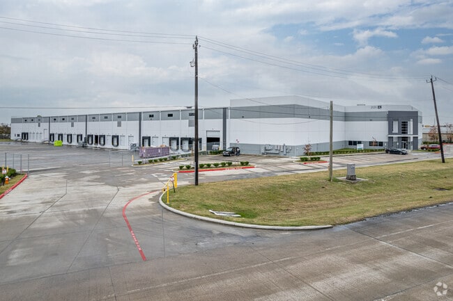
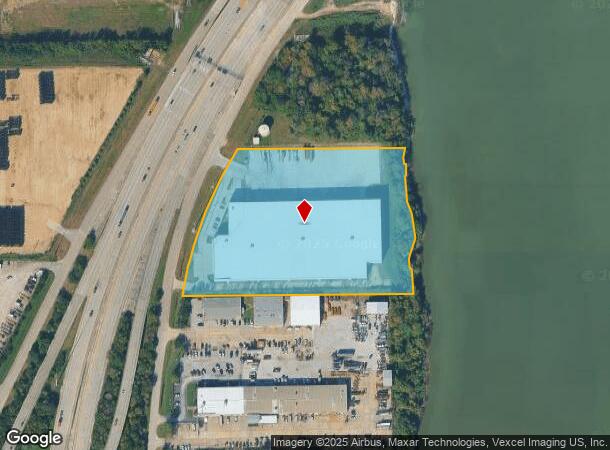
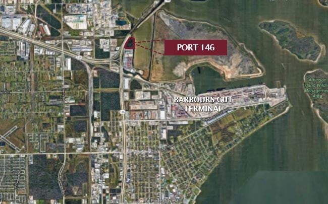
2020 Highway 146 N
0642220000074
Staashen
Warehouse
TRS 13E-3 13F & 13G STAASHEN
AE
Harris
48201C0935M
Texas
2024
7.94 AC
2025
East-Southeast Far
343601
Houston
140,514 SF
Houston-The Woodlands-Sugar Land, TX
DEMOGRAPHICS near 2020 Highway 146 N
1 Mile
3 Mile
5 Mile
2024 Total Population
0
17,114
61,473
2029 Population
0
17,560
62,914
Pop Growth 2024-2029
0.00%
+ 2.61%
+ 2.34%
Average Age
0
39
38
2024 Total Households
0
6,100
21,266
HH Growth 2024-2029
0.00%
+ 2.41%
+ 2.23%
Median Household Inc
$0
$67,680
$72,108
Avg Household Size
.00
2.80
2.80
2024 Avg HH Vehicles
.00
2.00
2.00
Median Home Value
$0
$183,016
$192,947
Median Year Built
0
1979
1980
Nearby Places
Map Layers
Map Styles
 Street
 Aerial
- Restaurants
- Banks
- Shops
- Fitness
- Groceries
PUBLIC TRANSPORTATION
AIRPORT
William P Hobby
DRIVE
WALK
Distance
William P Hobby
36 min
22.6 mi
George Bush Intcntl/Houston
DRIVE
WALK
Distance
George Bush Intcntl/Houston
45 min
35.4 mi
Freight Ports
Port of Houston
DRIVE
WALK
Distance
Port of Houston
28 min
18.3 mi
SALE & LEASE HISTORY
LISTING DATE
SALE/LEASE

Jun 14, 2019
For Sale
Feb 07, 2018
For Lease
Nearby Properties
Address
Land Use
TOTAL SIZE
Lot Size
Zoning
Address
Land Use
TOTAL SIZE
Lot Size
Zoning
Address
Land Use
TOTAL SIZE
Lot Size
Zoning
45.75 AC
Address
Land Use
TOTAL SIZE
Lot Size
Zoning
45.78 AC
Address
Land Use
TOTAL SIZE
Lot Size
Zoning
36.31 AC
Address
Land Use
TOTAL SIZE
Lot Size
Zoning
38.27 AC
Address
Land Use
TOTAL SIZE
Lot Size
Zoning
Address
Land Use
TOTAL SIZE
Lot Size
Zoning
2,211,400 SF
101.25 AC
Address
Land Use
TOTAL SIZE
Lot Size
Zoning
Address
Land Use
TOTAL SIZE
Lot Size
Zoning
46.10 AC
Address
Land Use
TOTAL SIZE
Lot Size
Zoning
1,120,800 SF
35.24 AC
Address
Land Use
TOTAL SIZE
Lot Size
Zoning
711,094 SF
35.47 AC
Address
Land Use
TOTAL SIZE
Lot Size
Zoning
348,294 SF
18.02 AC
Address
Land Use
TOTAL SIZE
Lot Size
Zoning
Address
Land Use
TOTAL SIZE
Lot Size
Zoning
26.28 AC
Address
Land Use
TOTAL SIZE
Lot Size
Zoning
95.07 AC
Address
Land Use
TOTAL SIZE
Lot Size
Zoning
365,728 SF
25.30 AC
Address
Land Use
TOTAL SIZE
Lot Size
Zoning
55.07 AC
Address
Land Use
TOTAL SIZE
Lot Size
Zoning
306,482 SF
22.96 AC
Address
Land Use
TOTAL SIZE
Lot Size
Zoning
26.32 AC
Address
Land Use
TOTAL SIZE
Lot Size
Zoning
289,475 SF
14.83 AC
Address
Land Use
TOTAL SIZE
Lot Size
Zoning
40.46 AC
Address
Land Use
TOTAL SIZE
Lot Size
Zoning
162,015 SF
10.49 AC
Address
Land Use
TOTAL SIZE
Lot Size
Zoning
297,671 SF
20.07 AC
Address
Land Use
TOTAL SIZE
Lot Size
Zoning
21.15 AC
Address
Land Use
TOTAL SIZE
Lot Size
Zoning
258,486 SF
34.76 AC
Address
Land Use
TOTAL SIZE
Lot Size
Zoning
165,666 SF
10.18 AC
Address
Land Use
TOTAL SIZE
Lot Size
Zoning
22.94 AC
Address
Land Use
TOTAL SIZE
Lot Size
Zoning
425.97 AC
Address
Land Use
TOTAL SIZE
Lot Size
Zoning
267,540 SF
15.78 AC
Address
Land Use
TOTAL SIZE
Lot Size
Zoning
The World's #1 Commercial Real Estate Marketplace
Connect with us
© 2026 CoStar Group
The information above has been obtained from sources believed reliable. While we do not doubt its accuracy we have not verified it and make no guarantee, warranty or representation about it. It is your responsibility to independently confirm its accuracy and completeness. Any projections, opinions, assumptions, or estimates used are for example only and do not represent the current or future performance of the property. The value of this transaction to you depends on tax and other factors which should be evaluated by your tax, financial, and legal advisors. You and your advisors should conduct a careful, independent investigation of the property to determine to your satisfaction the suitability of the property for your needs.