Property Record
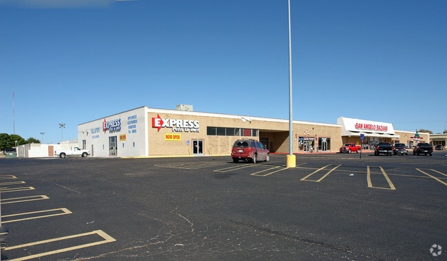
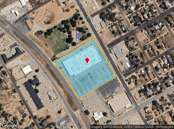
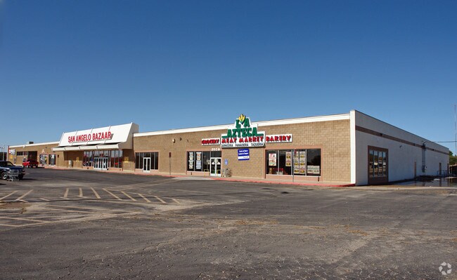
2020 N Bryant Blvd, San Angelo, TX 76903
NEARBY LISTINGS FOR SALE OR LEASE
Property Detail
2020 N Bryant Blvd
San Angelo, TX
Wade Turner Add
25-47000-0006-003-00
ACRES: 6.146 BLK: 6 SUBD: WADE & TURNER ADDITION 6.1458 ACRES BEING LOT 3 (REPLAT)
Theater
Tom Green
X
Texas
48451C0480E
3
2025
6.15 AC
2025
Texas West Area
001800
Other Market Areas
53,850 SF
DEMOGRAPHICS near 2020 N Bryant Blvd
1 mile
3 mile
5 mile
2024 Total Population
7,155
47,080
87,650
2029 Population
7,241
46,976
87,214
Pop Growth 2024-2029
+ 1.20%
(0.22%)
(0.50%)
Average Age
37
38
37
2024 Total Households
2,665
18,345
34,325
HH Growth 2024-2029
+ 1.20%
(0.21%)
(0.52%)
Median Household Inc
$34,305
$47,931
$56,006
Avg Household Size
2.50
2.40
2.40
2024 Avg HH Vehicles
1.00
2.00
2.00
Median Home Value
$86,129
$118,816
$143,419
Median Year Built
1960
1961
1972
Nearby Places
Map Layers
Map Styles
 Street
 Aerial
Transit
 Traffic
 Biking
Places
Listings with unknown addresses are not visible on the map
- Restaurants
- Banks
- Shops
- Fitness
- Groceries
PUBLIC TRANSPORTATION
AIRPORT
San Angelo Regional/Mathis Field
Drive
Walk
Distance
San Angelo Regional/Mathis Field
21 min
10.8 mi
SALE & LEASE HISTORY
LISTING DATE
SALE/LEASE

Sep 24, 2016
For Lease
Nearby Properties
Address
Land Use
TOTAL SIZE
Lot Size
Zoning
Address
Land Use
TOTAL SIZE
Lot Size
Zoning
187,200 SF
4.01 AC
Address
Land Use
TOTAL SIZE
Lot Size
Zoning
251,466 SF
14.08 AC
Address
Land Use
TOTAL SIZE
Lot Size
Zoning
204,347 SF
25.94 AC
Address
Land Use
TOTAL SIZE
Lot Size
Zoning
141,720 SF
7.56 AC
Address
Land Use
TOTAL SIZE
Lot Size
Zoning
Address
Land Use
TOTAL SIZE
Lot Size
Zoning
81,000 SF
7.53 AC
Address
Land Use
TOTAL SIZE
Lot Size
Zoning
50,688 SF
2.11 AC
Address
Land Use
TOTAL SIZE
Lot Size
Zoning
44,550 SF
3.67 AC
Address
Land Use
TOTAL SIZE
Lot Size
Zoning
69,776 SF
3.59 AC
Address
Land Use
TOTAL SIZE
Lot Size
Zoning
72,000 SF
4.57 AC
Address
Land Use
TOTAL SIZE
Lot Size
Zoning
81,900 SF
10.69 AC
Address
Land Use
TOTAL SIZE
Lot Size
Zoning
39,960 SF
8.59 AC
Address
Land Use
TOTAL SIZE
Lot Size
Zoning
16,568 SF
2.18 AC
Address
Land Use
TOTAL SIZE
Lot Size
Zoning
73,884 SF
5.37 AC
Address
Land Use
TOTAL SIZE
Lot Size
Zoning
12,840 SF
1.99 AC
Address
Land Use
TOTAL SIZE
Lot Size
Zoning
70,000 SF
7.93 AC
Address
Land Use
TOTAL SIZE
Lot Size
Zoning
30,781 SF
18.21 AC
Address
Land Use
TOTAL SIZE
Lot Size
Zoning
Address
Land Use
TOTAL SIZE
Lot Size
Zoning
Address
Land Use
TOTAL SIZE
Lot Size
Zoning
39,679 SF
5 AC
Address
Land Use
TOTAL SIZE
Lot Size
Zoning
32,000 SF
1.17 AC
Address
Land Use
TOTAL SIZE
Lot Size
Zoning
29,868 SF
46.28 AC
Address
Land Use
TOTAL SIZE
Lot Size
Zoning
93,000 SF
15.15 AC
Address
Land Use
TOTAL SIZE
Lot Size
Zoning
43,480 SF
5.08 AC
Address
Land Use
TOTAL SIZE
Lot Size
Zoning
50,880 SF
5.19 AC
Address
Land Use
TOTAL SIZE
Lot Size
Zoning
60,450 SF
2.50 AC
Address
Land Use
TOTAL SIZE
Lot Size
Zoning
49,374 SF
1.12 AC
Address
Land Use
TOTAL SIZE
Lot Size
Zoning
233,256 SF
18.55 AC
Address
Land Use
TOTAL SIZE
Lot Size
Zoning
34,647 SF
2.63 AC
The World's #1 Commercial Real Estate Marketplace
Connect with us
© 2026 CoStar Group
The information above has been obtained from sources believed reliable. While we do not doubt its accuracy we have not verified it and make no guarantee, warranty or representation about it. It is your responsibility to independently confirm its accuracy and completeness. Any projections, opinions, assumptions, or estimates used are for example only and do not represent the current or future performance of the property. The value of this transaction to you depends on tax and other factors which should be evaluated by your tax, financial, and legal advisors. You and your advisors should conduct a careful, independent investigation of the property to determine to your satisfaction the suitability of the property for your needs.